Cambodia Google maps and Driving Directions
Get free driving directions, Google maps, traffic information for Cambodia, and Phnom Penh (GPS: 11 33 N 104 55 E), the capital city of the country located in (the) Southeastern Asia, bordering the Gulf of Thailand, between Thailand, Vietnam, and Laos.
Find any address in Phnom Penh on the Google map of Cambodia (CB) with ease or calculate your up to date itinerary to and from Cambodia or its neighboring counties like Laos, Thailand, Vietnam.
Sightseeing and exploring in Asia starts here, thanks to Google because its Earth Engine combines a multi-petabyte catalog of updated satellite imagery and geospatial datasets with planetary-scale analysis capabilities. Wonder the world, use the satellite map function of the Google maps to explore or see differences on the Earth’s surface, inland, or the surrounding areas of Cambodia.
Google Maps Cambodia
Located on the Indochinese peninsula in southeast Asia, Cambodia has emerged from genocide, civil war, and invasion from Vietnam. Tourists are returning. Rice is the principal crop.
Cambodia is mostly low, flat plains; mountains in southwest and north.
The map above fully covers Cambodia with its road routes from cities to towns, road intersections in any region, provinces, prefectures, also with free driving directions in Phnom Penh or to the neighboring towns and countries. To look at the detailed map about a particular quarter in Phnom Penh, please click on the area and zoom to the place you are interested in the Google maps of Cambodia (CB).
Be creative, use the extras of this Google map; This is a detailed, clear, zoomable, large road map of Cambodia with its administrative divisions; 24 provinces (khett, singular and plural) and 1 municipality (krong, singular and plural)provinces: Banteay Meanchey, Battambang, Kampong Cham, Kampong Chhnang, Kampong Speu, Kampong Thom, Kampot, Kandal, Kep, Koh Kong, Kratie, Mondolkiri, Oddar Meanchey, Pailin, Preah Vihear, Prey Veng, Pursat, Ratanakiri, Siem Reap, Sihanoukville, Stung Treng, Svay Rieng, Takeo, Tbong Khmummunicipalities: Phnom Penh (Phnum Penh).
The interactive map above is also may be used as the satellite map of Cambodia, or as a reverse search map for finding an address from its GPS coordinates.
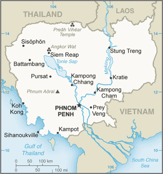
Situated on the Indochinese peninsula, Cambodia is bordered by Thailand and Laos on the north and Vietnam on the east and south. The Gulf of Thailand is off the western coast. The size of Missouri, the country consists chiefly of a large alluvial plain ringed by mountains with the Mekong River to the east. The plain is centered around Lake Tonle Sap, which is a natural storage basin of the Mekong.
Cambodia (area: 181 035 sq km / 69 897,98 sq mi), where the official language is Khmer, lying in Asia and using the currency; Cambodian riel (KHR), since 1980, set their clock to UTC+7. That means they are 12 hours ahead of Washington DC during Standard Time in Phnom Penh, the capital. Note to the time difference: N/A.
The climate in Cambodia; Tropical. High temperatures throughout the year. Heavy rainfall during MayOctober monsoon.
Geography in a nutshell; Mostly low-lying basin. Tônlé Sap (Great Lake) drains into the Mekong River. Forested mountains and plateau east of the Mekong.
Click here for more detailed information about Cambodia.
Driving directions Cambodia
The Google maps and Google Satellite maps of Cambodia above showing the country, located next to Laos, Thailand, Vietnam. For your further reference, the latitude and longitude coordinates of Cambodia are 13 00 N, 105 00 E , while the capital, Phnom Penh found at 11 33 N 104 55 E.
When you are traveling around Cambodia, Phnom Penh, or its other cities, use this routing tool, providing up to date route planning service free of charge.
Look no further; get accurate driving directions in Cambodia, Southeast Asia, by filling the route planner form below.
Since Google acquired and introduced its digitalized maps in 2004, you’re probably familiar with its base functions, like finding an address or driving directions to locations. Still, Google maps also accommodate bicyclists, pedestrians, and also public transportation with special directions and customizable routes.
About Cambodia and the capital, Phnom Penh
 |
 |
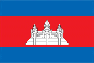
| The national flag of Cambodia | Borderline map of Cambodia |
| Flag description: three horizontal bands of blue (top), red (double width), and blue with a white three-towered temple representing Angkor Wat outlined in black in the center of the red band; red and blue are traditional Cambodian colors. Note: only national flag to incorporate an actual building into its design. | Border length: total: 2,530 km. Border countries (total: 3): Laos 555 km, Thailand 817 km, Vietnam 1,158 km. |
Did you know about Cambodia?
- Cambodia was a French Protectorate until 1949 when it became nominally independent once more. Full independence was achieved in 1953.
- Cambodia has many impressive temples, dating from when the country was the center of the Khmer Empire.
- Once the center of the Khmer Empire, Cambodias jungles reveal such structures as the vast 12th-century temple of Angkor Wat.
Facts of Cambodia (CB)
Name conventional long form: Kingdom of Cambodia, conventional short form: Cambodia, local long form: Preahreacheanachakr Kampuchea (phonetic transliteration), local short form: Kampuchea Kampuchea, former: Khmer Republic, Democratic Kampuchea, People’s Republic of Kampuchea, State of Cambodia, etymology: the English name Cambodia is an anglicization of the French Cambodge, which is the French transliteration of the native name Kampuchea
Codes: ISO; CB, Internet; .kh
Capital city: Phnom Penh
Language(s): Khmer (official language) 96.3%, other 3.7% (2008 estimate)
National holiday(s): Independence Day, 9 November (1953)
Motto: Nation, Religion, King
Currency: Cambodian riel (KHR), since 1980
GPS: 13 00 N, 105 00 E, Phnom Penh; 11 33 N 104 55 E
Location: Southeastern Asia, bordering the Gulf of Thailand, between Thailand, Vietnam, and Laos
Geography note: a land of paddies and forests dominated by the Mekong River and Tonle Sap (Southeast Asia’s largest freshwater lake)
Land boundaries: Laos 555 km, Thailand 817 km, Vietnam 1,158 km, total: 2,530 km
Maritime boundaries: N/A
Coastline: 443 km
Area: total: 181,035 sq km; land: 176,515 sq km, water: 4,520 sq km (total 69 897,98 mi2), slightly smaller than Oklahoma.
Roadways: total: 44,709 km, paved: 3,607 km, unpaved: 41,102 km (2010)
Waterways: 3,700 km (mainly on Mekong River) (2012)
Local time (capital): UTC+7, 12 hours ahead of Washington DC during Standard Time
Note to the local time: N/A
Population in Cambodia: 16 245 729
Population in Phnom Penh: 1 169 800 (including the metropolitan areas)
Urbanization: urban population: 20.7% of total population (2015)
Major urban areas population: PHNOM PENH (capital) 1.731 million (2015)
Population growth rate: 1.56% (2016 estimate)
Birth rate: 23.4 births / 1,000 population (2016 estimate)
Death rate: 7.6 deaths / 1,000 population (2016 estimate)
Age structure: 0-14 years: 31.24% (male 2,515,435 / female 2,468,855) 15-24 years: 19.02% (male 1,501,070 / female 1,533,500) 25-54 years: 40.18% (male 3,139,851 / female 3,271,077) 55-64 years: 5.43% (male 342,063 / female 524,114) 65 years and over: 4.14% (male 248,454 / female 412,804) (2016 estimate)
Median age: total: 24.9 years; male: 24.2 years, female: 25.6 years (2016 estimate)
Ethnic groups: Khmer 97.6%, Cham 1.2%, Chinese 0.1%, Vietnamese 0.1%, other 0.9% (2013 estimate)
Religions: Buddhist (official) 96.9%, Muslim 1.9%, Christian 0.4%, other 0.8% (2008 estimate)
Government type: Parliamentary elective constitutional monarchy
Legal system: civil law system (influenced by the UN Transitional Authority in Cambodia) customary law, Communist legal theory, and common law
National anthem: Nokor Reach
Known national hazards: monsoonal rains (June to November); flooding; occasional droughts
Major infectious diseases: The The degree of risk(s): very high food or waterborne diseases: bacterial diarrhea, hepatitis A, and typhoid fever vectorborne diseases: dengue fever, Japanese encephalitis, and malaria (2016)
Land use: agricultural land: 32.1%; arable land 22.7%; permanent crops 0.9%; permanent pasture 8.5%; forest: 56.5%; other: 11.4% (2011 estimate)
Agricultural products: rice, rubber, corn, vegetables, cashews, cassava (manioc, tapioca), silk
Industries: tourism, garments, construction, rice milling, fishing, wood and wood products, rubber, cement, gem mining, textiles
Export commodities: clothing, timber, rubber, rice, fish, tobacco, footwear
Main export partners: US 23.1%, UK 8.8%, Germany 8.2%, Japan 7.4%, Canada 6.7%, China 5.1%, Vietnam 5%, Thailand 4.9%, Netherlands 4.1% (2015)
Import commodities: petroleum products, cigarettes, gold, construction materials, machinery, motor vehicles, pharmaceutical products
Main import partners: Thailand 28.7%, China 22.2%, Vietnam 16.4%, Hong Kong 6.1%, Singapore 5.7% (2015)
Navigate the countries in Southeast Asia faster and easier while driving, use the interactive Google maps for your driving directions. The continuously updated database contains over 220 countries and territories digitally mapped, hundreds of millions of businesses and places around the world positioned on the map.
Get fresh GPS navigation, traffic, and transit information – no matter what part of Cambodia, Phnom Penh, any other city and country in Asia, or the world you’re in.
Do you like this Cambodia information page? Please don’t forget to share it with others! Thank you.