Laos Google maps and Driving Directions
Get free driving directions, Google maps, traffic information for Laos, and Vientiane (GPS: 17 58 N 102 36 E), the capital city of the country located in (the) Southeastern Asia, northeast of Thailand, west of Vietnam.
Find any address in Vientiane on the Google map of Laos (LA) with ease or calculate your up to date itinerary to and from Laos or its neighboring counties like Cambodia, China, Myanmar, Thailand, Vietnam.
Sightseeing and exploring in Asia starts here, thanks to Google because its Earth Engine combines a multi-petabyte catalog of updated satellite imagery and geospatial datasets with planetary-scale analysis capabilities. Wonder the world, use the satellite map function of the Google maps to explore or see differences on the Earth’s surface, inland, or the surrounding areas of Laos.
Google Maps Laos
A French colony prior to 1953, Laos lies landlocked in southeast Asia. Heavily bombed during the Vietnam War, it fell in 1975 to communist insurgents, whose regime remains in power.
Laos is mostly rugged mountains; some plains and plateaus.
The map above fully covers Laos with its road routes from cities to towns, road intersections in any region, provinces, prefectures, also with free driving directions in Vientiane or to the neighboring towns and countries. To look at the detailed map about a particular quarter in Vientiane, please click on the area and zoom to the place you are interested in the Google maps of Laos (LA).
Be creative, use the extras of this Google map; This is a detailed, clear, zoomable, large road map of Laos with its administrative divisions; 17 provinces (khoueng, singular and plural) and 1 capital city* (nakhon luang, singular and plural); Attapu, Bokeo, Bolikhamxai, Champasak, Houaphan, Khammouan, Louangnamtha, Louangphabang, Oudomxai, Phongsali, Salavan, Savannakhet, Viangchan (Vientiane)*, Viangchan, Xaignabouli, Xaisomboun, Xekong, Xiangkhouang.
The interactive map above is also may be used as the satellite map of Laos, or as a reverse search map for finding an address from its GPS coordinates.
A landlocked nation in Southeast Asia occupying the northwest portion of the Indochinese peninsula, Laos is surrounded by China, Vietnam, Cambodia, Thailand, and Myanmar. It is twice the size of Pennsylvania. Laos is a mountainous country, especially in the north, where peaks rise above 9,000 ft (2,800 m). Dense forests cover the northern and eastern areas. The Mekong River, which forms the boundary with Myanmar and Thailand, flows through the country for 932 mi (1,500 km) of its course.
Laos (area: 236 800 sq km / 91 428,95 sq mi), where the official language is Lao, lying in Asia and using the currency; Lao kip (LAK), since 1954, set their clock to UTC+7. That means they are 12 hours ahead of Washington DC during Standard Time in Vientiane, the capital. Note to the time difference: N/A.
The climate in Laos; Monsoon rains SeptemberMay. The rest of the year is hot and dry.
Geography in a nutshell; Largely forested mountains, broadening in the north to a plateau. Lowlands along the Mekong Valley.
Click here for more detailed information about Laos.
Driving directions Laos
The Google maps and Google Satellite maps of Laos above showing the country, located next to Cambodia, China, Myanmar, Thailand, Vietnam. For your further reference, the latitude and longitude coordinates of Laos are 18 00 N, 105 00 E , while the capital, Vientiane found at 17 58 N 102 36 E.
When you are traveling around Laos, Vientiane, or its other cities, use this routing tool, providing up to date route planning service free of charge.
Look no further; get accurate driving directions in Laos, Southeast Asia, by filling the route planner form below.
Since Google acquired and introduced its digitalized maps in 2004, you’re probably familiar with its base functions, like finding an address or driving directions to locations. Still, Google maps also accommodate bicyclists, pedestrians, and also public transportation with special directions and customizable routes.
About Laos and the capital, Vientiane
 |
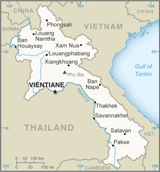 |
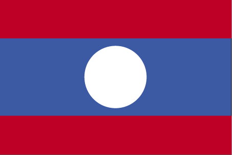
| The national flag of Laos | Borderline map of Laos |
| Flag description: three horizontal bands of red (top), blue (double width), and red with a large white disk centered in the blue band; the red bands recall the bloodshed for liberation; the blue band represents the Mekong River and prosperity; the white disk symbolizes the full moon against the Mekong River, but also signifies the unity of the people under the Lao People’s Revolutionary Party, as well as the country’s bright future. | Border length: total: 5,274 km. Border countries (total: 5): Myanmar 238 km, Cambodia 555 km, China 475 km, Thailand 1,845 km, Vietnam 2,161 km. |
Did you know about Laos?
- A French protectorate from the end of the 19th century, Laos gained full independence in 1953. It has been under communist rule since 1975.
- Three small Laotian kingdoms were unified under French control in 1899.
- Meaning “Mother of rivers, the Mekong in Laos is a rich source of fish, irrigation water for the paddy fields, and serves as the countrys main watery highway.
Facts of Laos (LA)
Name conventional long form: Lao People’s Democratic Republic, conventional short form: Laos, local long form: Sathalanalat Paxathipatai Paxaxon Lao, local short form: Mueang Lao (unofficial), etymology: name means “Land of the Lao [people]”
Codes: ISO; LA, Internet; .la
Capital city: Vientiane
Language(s): Lao (official language), French, English, various ethnic languages
National holiday(s): Republic Day, 2 December (1975)
Motto: Peace, independence, democracy, unity and prosperity
Currency: Lao kip (LAK), since 1954
GPS: 18 00 N, 105 00 E, Vientiane; 17 58 N 102 36 E
Location: Southeastern Asia, northeast of Thailand, west of Vietnam
Geography note: landlocked country; most of the country is mountainous and thickly forested; the Mekong River forms a large part of the western boundary with Thailand
Land boundaries: Myanmar 238 km, Cambodia 555 km, China 475 km, Thailand 1,845 km, Vietnam 2,161 km, total: 5,274 km
Maritime boundaries: N/A
Coastline: 0 km (landlocked country)
Area: total: 236,800 sq km; land: 230,800 sq km, water: 6,000 sq km (total 91 428,95 mi2), slightly larger than Utah.
Roadways: total: 39,586 km, paved: 5,415 km, unpaved: 34,171 km (2009)
Waterways: 4,600 km (primarily on the Mekong River and its tributaries; 2,900 additional km are intermittently navigable by craft drawing less than 0.5 m) (2012)
Local time (capital): UTC+7, 12 hours ahead of Washington DC during Standard Time
Note to the local time: N/A
Population in Laos: 6 961 210
Population in Vientiane: 194 200 (including the metropolitan areas)
Urbanization: urban population: 38.6% of total population (2015)
Major urban areas population: VIENTIANE (capital) 997,000 (2015)
Population growth rate: 1.53% (2016 estimate)
Birth rate: 23.9 births / 1,000 population (2016 estimate)
Death rate: 7.5 deaths / 1,000 population (2016 estimate)
Age structure: 0-14 years: 33.4% (male 1,184,344 / female 1,159,731) 15-24 years: 21.29% (male 742,073 / female 751,983) 25-54 years: 36.1% (male 1,250,108 / female 1,283,834) 55-64 years: 5.36% (male 184,183 / female 192,298) 65 years and over: 3.85% (male 122,485 / female 148,034) (2016 estimate)
Median age: total: 22.7 years; male: 22.4 years, female: 23 years (2016 estimate)
Ethnic groups: Lao 54.6%, Khmou 10.9%, Hmong 8%, Tai 3.8%, Phuthai 3.3%, Lue 2.2%, Katang 2.1%, Makong 2.1%, Akha 1.6%, other 10.4%, unspecified 1% (2005 estimate)
Religions: Buddhist 66.8%, Christian 1.5%, other 31%, unspecified 0.7% (2005 estimate)
Government type: Communist republic
Legal system: civil law system similar in form to the French system
National anthem: Pheng Xat Lao (Lao National Anthem)
Known national hazards: floods, droughts
Major infectious diseases: The degree of risk(s): very high food or waterborne diseases: bacterial and protozoal diarrhea, hepatitis A, and typhoid fever vectorborne diseases: dengue fever and malaria (2016)
Land use: agricultural land: 10.6%; arable land 6.2%; permanent crops 0.7%; permanent pasture 3.7%; forest: 67.9%; other: 21.5% (2011 estimate)
Agricultural products: sweet potatoes, vegetables, corn, coffee, sugarcane, tobacco, cotton, tea, peanuts, rice; cassava (manioc, tapioca), water buffalo, pigs, cattle, poultry
Industries: mining (copper, tin, gold, gypsum); timber, electric power, agricultural processing, rubber, construction, garments, cement, tourism
Export commodities: wood products, coffee, electricity, tin, copper, gold, cassava
Main export partners: Thailand 30.4%, China 27%, Vietnam 17.6% (2015)
Import commodities: machinery and equipment, vehicles, fuel, consumer goods
Main import partners: Thailand 60.9%, China 18.6%, Vietnam 7.3% (2015)
Navigate the countries in Southeast Asia faster and easier while driving, use the interactive Google maps for your driving directions. The continuously updated database contains over 220 countries and territories digitally mapped, hundreds of millions of businesses and places around the world positioned on the map.
Get fresh GPS navigation, traffic, and transit information – no matter what part of Laos, Vientiane, any other city and country in Asia, or the world you’re in.
Do you like this Laos information page? Please don’t forget to share it with others! Thank you.