Antigua and Barbuda Google maps and Driving Directions
Get free driving directions, Google maps, traffic information for Antigua and Barbuda, and St. John’s (GPS: 17 07 N 61 51 W), the capital city of the country located in (the) Caribbean, islands between the Caribbean Sea and the North Atlantic Ocean, east-southeast of Puerto Rico.
Find any address in St. John’s on the Google map of Antigua and Barbuda (AG) with ease or calculate your up to date itinerary to and from Antigua and Barbuda or its neighboring counties like N/A.
Sightseeing and exploring in America starts here, thanks to Google because its Earth Engine combines a multi-petabyte catalog of updated satellite imagery and geospatial datasets with planetary-scale analysis capabilities. Wonder the world, use the satellite map function of the Google maps to explore or see differences on the Earth’s surface, inland, or the surrounding areas of Antigua and Barbuda.
Google Maps Antigua and Barbuda
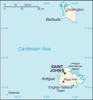
A former colony of Spain, France, and the UK, Antigua and Barbuda lies at the outer edge of the Leeward Islands group in the Caribbean, and includes the uninhabited islet of Redonda.
Antigua and Barbuda is mostly low-lying limestone and coral islands, with some higher volcanic areas.
The map above fully covers Antigua and Barbuda with its road routes from cities to towns, road intersections in any region, provinces, prefectures, also with free driving directions in St. John’s or to the neighboring towns and countries. To look at the detailed map about a particular quarter in Saint John’s, please click on the area and zoom to the place you are interested in the Google maps of Antigua and Barbuda (AG).
Be creative, use the extras of this Google map; This is a detailed, clear, zoomable, large road map of Antigua and Barbuda with its administrative divisions; 6 parishes and 2 dependencies*; Barbuda*, Redonda*, Saint George, Saint John, Saint Mary, Saint Paul, Saint Peter, Saint Philip.
The interactive map above is also may be used as the satellite map of Antigua and Barbuda, or as a reverse search map for finding an address from its GPS coordinates.
Antigua, the larger of the two main islands, is 108 sq mi (280 sq km). The island dependencies of Redonda (an uninhabited rocky islet) and Barbuda (a coral island formerly known as Dulcina) are 0.5 sq mi (1.30 sq km) and 62 sq mi (161 sq km), respectively.
Antigua and Barbuda (area: 442 sq km / 170,66 sq mi), where the official language is English, lying in America and using the currency; East Caribbean dollar (XCD), since 1965, set their clock to UTC-4. That means they are 1 hour ahead of Washington DC during Standard Time in Saint John’s, the capital. Note to the time difference: N/A.
The climate in Antigua and Barbuda; Tropical, moderated by trade winds and sea breezes. Humidity and rainfall are low for the region.
Geography in a nutshell; Mainly low-lying limestone and coral islands with some higher volcanic areas. Antiguas coast is indented with bays and harbors.
Click here for more detailed information about Antigua and Barbuda.
Driving directions Antigua and Barbuda
The Google maps and Google Satellite maps of Antigua and Barbuda above showing the country, located next to N/A. For your further reference, the latitude and longitude coordinates of Antigua and Barbuda are 17 03 N, 61 48 W , while the capital, Saint John’s found at 17 07 N 61 51 W.
When you are traveling around Antigua and Barbuda, Saint John’s, or its other cities, use this routing tool, providing up to date route planning service free of charge.
Look no further; get accurate driving directions in Antigua and Barbuda, Central America and the Caribbean, by filling the route planner form below.
Since Google acquired and introduced its digitalized maps in 2004, you’re probably familiar with its base functions, like finding an address or driving directions to locations. Still, Google maps also accommodate bicyclists, pedestrians, and also public transportation with special directions and customizable routes.
About Antigua and Barbuda and the capital, St. John’s
 |
 |
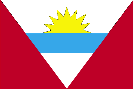
| The national flag of Antigua and Barbuda | Borderline map of Antigua and Barbuda |
| Flag description: red, with an inverted isosceles triangle based on the top edge of the flag; the triangle contains three horizontal bands of black (top), light blue, and white, with a yellow rising sun in the black band; the sun symbolizes the dawn of a new era, black represents the African heritage of most of the population, blue is for hope, and red is for the dynamism of the people; the “V” stands for victory; the successive yellow, blue, and white coloring is also meant to evoke the country’s tourist attractions of sun, sea, and sand. | Border length: 0 km. |
Did you know about Antigua and Barbuda?
- From 1632 until formal independence granted in 1981, Antigua and its neighbor Barbuda were British colonies.
- In 1865, Redonda was “claimed by an eccentric Englishman as a kingdom for his son.
- In September 2017, Hurricane Irma damaged or destroyed 95% of Barbuda’s buildings and infrastructure and as a result, all the island’s inhabitants were evacuated to Antigua, leaving Barbuda empty for the first time in modern history.
Facts of Antigua and Barbuda (AG)
Name conventional long form: none, conventional short form: Antigua and Barbuda, etymology: “antiguo” is Spanish for “ancient” or “old”; the island was discovered by Christopher COLUMBUS in 1493 and, according to tradition, named by him after the church of Santa Maria la Antigua (Old Saint Mary’s) in Seville; “barbuda” is Spanish for “bearded” and the adjective may refer to the alleged beards of the indigenous people or to the island’s bearded-fig trees
Codes: ISO; AG, Internet; .ag
Capital city: St. John’s
Language(s): English (official language), Antiguan creole
National holiday(s): Independence Day (National Day), 1 November (1981)
Motto: Each Endeavouring, All Achieving
Currency: East Caribbean dollar (XCD), since 1965
GPS: 17 03 N, 61 48 W, St. John’s; 17 07 N 61 51 W
Location: Caribbean, islands between the Caribbean Sea and the North Atlantic Ocean, east-southeast of Puerto Rico
Geography note: Antigua has a deeply indented shoreline with many natural harbors and beaches; Barbuda has a large western harbor
Land boundaries: N/A, 0 km
Maritime boundaries: Caribbean Sea
Coastline: 153 km
Area: total: 442.6 sq km; land: 442.6 sq km, water: 0 sq km (total 170,66 mi2), 2.5 times the size of Washington, DC.
Roadways: total: 1,170 km, paved: 386 km, unpaved: 784 km (2011)
Waterways: N/A
Local time (capital): UTC-4, 1 hour ahead of Washington DC during Standard Time
Note to the local time: N/A
Population in Antigua and Barbuda: 103 050
Population in Saint John’s: 23 500 (including the metropolitan areas)
Urbanization: urban population: 23.8% of total population (2015)
Major urban areas population: SAINT JOHN’S (capital) 22,000 (2014)
Population growth rate: 1.23% (2016 estimate)
Birth rate: 15.8 births / 1,000 population (2016 estimate)
Death rate: 5.7 deaths / 1,000 population (2016 estimate)
Age structure: 0-14 years: 23.36% (male 11,107 / female 10,754) 15-24 years: 17% (male 7,918 / female 7,992) 25-54 years: 42.31% (male 18,085 / female 21,509) 55-64 years: 9.53% (male 4,021 / female 4,894) 65 years and over: 7.8% (male 3,136 / female 4,165) (2016 estimate)
Median age: total: 31.6 years; male: 29.8 years, female: 33.2 years (2016 estimate)
Ethnic groups: black 87.3%, mixed 4.7%, hispanic 2.7%, white 1.6%, other 2.7%, unspecified 0.9% (2011 estimate)
Religions: Protestant 68.3% (Anglican 17.6%, Seventh Day Adventist 12.4%, Pentecostal 12.2%, Moravian 8.3%, Methodist 5.6%, Wesleyan Holiness 4.5%, Church of God 4.1%, Baptist 3.6%), Roman Catholic 8.2%, other 12.2%, unspecified 5.5%, none 5.9% (2011 estimate)
Government type: Parliamentary democracy under constitutional monarchy
Legal system: common law based on the English model
National anthem: Fair Antigua, We Salute Thee
Known national hazards: hurricanes and tropical storms (July to October); periodic droughts
Major infectious diseases: note: active local transmission of Zika virus by Aedes species mosquitoes has been identified in this country (as of August 2016); it poses an important risk (a large number of cases possible) among US citizens if bitten by an infective mosquito; other less common ways to get Zika are through sex, via blood transfusion, or during pregnancy, in which the pregnant woman passes Zika virus to her fetus (2016)
Land use: agricultural land: 20.5%; arable land 9.1%; permanent crops 2.3%; permanent pasture 9.1%; forest: 22.3%; other: 57.2% (2011 estimate)
Agricultural products: cotton, fruits, vegetables, bananas, coconuts, cucumbers, mangoes, sugarcane; livestock
Industries: tourism, construction, light manufacturing (clothing, alcohol, household appliances)
Export commodities: petroleum products, bedding, handicrafts, electronic components, transport equipment, food and live animals
Main export partners: N/A
Import commodities: food and live animals, machinery and transport equipment, manufactures, chemicals, oil
Main import partners: N/A
Navigate the countries in Central America and the Caribbean faster and easier while driving, use the interactive Google maps for your driving directions. The continuously updated database contains over 220 countries and territories digitally mapped, hundreds of millions of businesses and places around the world positioned on the map.
Get fresh GPS navigation, traffic, and transit information – no matter what part of Antigua and Barbuda, St. John’s, any other city and country in America, or the world you’re in.
Do you like this Antigua and Barbuda information page? Please don’t forget to share it with others! Thank you.