Suriname Google maps and Driving Directions
Get free driving directions, Google maps, traffic information for Suriname, and Paramaribo (GPS: 5 50 N 55 10 W), the capital city of the country located in (the) Northern South America, bordering the North Atlantic Ocean, between French Guiana and Guyana.
Find any address in Paramaribo on the Google map of Suriname (SR) with ease or calculate your up to date itinerary to and from Suriname or its neighboring counties like Brazil, Guyana.
Sightseeing and exploring in America starts here, thanks to Google because its Earth Engine combines a multi-petabyte catalog of updated satellite imagery and geospatial datasets with planetary-scale analysis capabilities. Wonder the world, use the satellite map function of the Google maps to explore or see differences on the Earth’s surface, inland, or the surrounding areas of Suriname.
Google Maps Suriname
Suriname is a former Dutch colony on the north coast of South America. Democracy was restored in 1991, after almost 11 years of military rule. The Netherlands is still the main supplier of aid.
Suriname is mostly rolling hills; narrow coastal plain with swamps.
The map above fully covers Suriname with its road routes from cities to towns, road intersections in any region, provinces, prefectures, also with free driving directions in Paramaribo or to the neighboring towns and countries. To look at the detailed map about a particular quarter in Paramaribo, please click on the area and zoom to the place you are interested in the Google maps of Suriname (SR).
Be creative, use the extras of this Google map; This is a detailed, clear, zoomable, large road map of Suriname with its administrative divisions; 10 districts (distrikten, singular – distrikt); Brokopondo, Commewijne, Coronie, Marowijne, Nickerie, Para, Paramaribo, Saramacca, Sipaliwini, Wanica.
The interactive map above is also may be used as the satellite map of Suriname, or as a reverse search map for finding an address from its GPS coordinates.
Suriname lies on the northeast coast of South America, with Guyana to the west, French Guiana to the east, and Brazil to the south. It is about one-tenth larger than Michigan. The principal rivers are the Corantijn on the Guyana border, the Marowijne in the east, and the Suriname, on which the capital city of Paramaribo is situated.
Suriname (area: 163 820 sq km / 63 251,23 sq mi), where the official language is Dutch, lying in America and using the currency; Surinamese dollar (SRD), since 2004, set their clock to UTC-3. That means they are 2 hours ahead of Washington DC during Standard Time in Paramaribo, the capital. Note to the time difference: N/A.
The climate in Suriname; Tropical. Hot and humid, but cooled by trade winds. High rainfall, especially in the interior.
Geography in a nutshell; Mostly covered by tropical rainforest. Coastal plain rises to central plateaus and the Guiana Highlands.
Click here for more detailed information about Suriname.
Driving directions Suriname
The Google maps and Google Satellite maps of Suriname above showing the country, located next to Brazil, Guyana. For your further reference, the latitude and longitude coordinates of Suriname are 4 00 N, 56 00 W , while the capital, Paramaribo found at 5 50 N 55 10 W.
When you are traveling around Suriname, Paramaribo, or its other cities, use this routing tool, providing up to date route planning service free of charge.
Look no further; get accurate driving directions in Suriname, South America, by filling the route planner form below.
Since Google acquired and introduced its digitalized maps in 2004, you’re probably familiar with its base functions, like finding an address or driving directions to locations. Still, Google maps also accommodate bicyclists, pedestrians, and also public transportation with special directions and customizable routes.
About Suriname and the capital, Paramaribo
 |
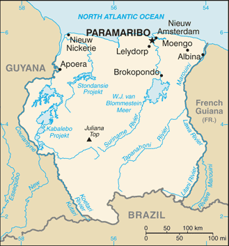 |
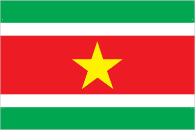
| The national flag of Suriname | Borderline map of Suriname |
| Flag description: five horizontal bands of green (top, double width), white, red (quadruple width), white, and green (double width); a large, yellow, five-pointed star is centered in the red band; red stands for progress and love; green symbolizes hope and fertility; white signifies peace, justice, and freedom; the star represents the unity of all ethnic groups; from its yellow light the nation draws strength to bear sacrifices patiently while working toward a golden future. | Border length: total: 1,907 km. Border countries (total: 3): Brazil 515 km, French Guiana 556 km, Guyana 836 km. |
Did you know about Suriname?
- Suriname was part of the Dutch kingdom until 1975. Since independence, there have been a series of coups and changes of constitution.
- In a 1667 Anglo-Dutch deal, Holland gained Suriname but lost New Amsterdam (now New York).
- Dutch influence is still evident in the capital city, Paramaribo, which boasts many Dutch-style buildings.
Facts of Suriname (SR)
Name conventional long form: Republic of Suriname, conventional short form: Suriname, local long form: Republiek Suriname, local short form: Suriname, former: Netherlands Guiana, Dutch Guiana, etymology: name may derive from the indigenous “Surinen” people who inhabited the area at the time of European contact
Codes: ISO; SR, Internet; .sr
Capital city: Paramaribo
Language(s): Dutch (official language), English (widely spoken), Sranang Tongo (Surinamese, sometimes called Taki-Taki, is native language of Creoles and much of the younger population and is lingua franca among others), Caribbean Hindustani (a dialect of Hindi), Javanese
National holiday(s): Independence Day, 25 November (1975)
Motto: Justitia, Pietas, Fides (Justice, Piety, Trust)
Currency: Surinamese dollar (SRD), since 2004
GPS: 4 00 N, 56 00 W, Paramaribo; 5 50 N 55 10 W
Location: Northern South America, bordering the North Atlantic Ocean, between French Guiana and Guyana
Geography note: smallest independent country on South American continent; mostly tropical rain forest; great diversity of flora and fauna that, for the most part, is increasingly threatened by new development; relatively small population, mostly along the coast
Land boundaries: Brazil 515 km, French Guiana 556 km, Guyana 836 km, total: 1,907 km
Maritime boundaries: N/A
Coastline: 386 km
Area: total: 163,820 sq km; land: 156,000 sq km, water: 7,820 sq km (total 63 251,23 mi2), slightly larger than Georgia.
Roadways: total: 4,304 km, paved: 1,130 km, unpaved: 3,174 km (2003)
Waterways: 1,200 km (most navigable by ships with drafts up to 7 m) (2011)
Local time (capital): UTC-3, 2 hours ahead of Washington DC during Standard Time
Note to the local time: N/A
Population in Suriname: 568 301
Population in Paramaribo: 278 000 (including the metropolitan areas)
Urbanization: urban population: 66% of total population (2015)
Major urban areas population: PARAMARIBO (capital) 234,000 (2014)
Population growth rate: 1.05% (2016 estimate)
Birth rate: 16 births / 1,000 population (2016 estimate)
Death rate: 6.1 deaths / 1,000 population (2016 estimate)
Age structure: 0-14 years: 25.15% (male 75,088 / female 72,261) 15-24 years: 17.46% (male 52,129 / female 50,141) 25-54 years: 44.36% (male 132,334 / female 127,562) 55-64 years: 7.16% (male 20,564 / female 21,394) 65 years and over: 5.86% (male 14,848 / female 19,503) (2016 estimate)
Median age: total: 29.5 years; male: 29.1 years, female: 29.9 years (2016 estimate)
Ethnic groups: Hindustani (also known locally as “East Indians”; their ancestors emigrated from northern India in the latter part of the 19th century) 37%, Creole (mixed white and black) 31%, Javanese 15%, “Maroons” (their African ancestors were brought to the country in the 17th and 18th centuries as slaves and escaped to the interior) 10%, Amerindian 2%, Chinese 2%, white 1%, other 2%
Religions: Hindu 27.4%, Protestant 25.2% (predominantly Moravian), Roman Catholic 22.8%, Muslim 19.6%, indigenous beliefs 5%
Government type: Unitary parliamentary republic
Legal system: civil law system influenced by Dutch civil law; note – the Commissie Nieuw Surinaamse Burgerlijk Wetboek completed drafting a new civil code in February 2009
National anthem: God zij met ons Suriname (God be with our Suriname)
Known national hazards: N/A
Major infectious diseases: The degree of risk(s): very high food or waterborne diseases: bacterial and protozoal diarrhea, hepatitis A, and typhoid fever vectorborne disease: dengue fever and malaria. Note: active local transmission of Zika virus by Aedes species mosquitoes has been identified in this country (as of August 2016); it poses an important risk (a large number of cases possible) among US citizens if bitten by an infective mosquito; other less common ways to get Zika are through sex, via blood transfusion, or during pregnancy, in which the pregnant woman passes Zika virus to her fetus (2016)
Land use: agricultural land: 0.5%; arable land 0.4%; permanent crops 0%; permanent pasture 0.1%; forest: 94.6%; other: 4.9% (2011 estimate)
Agricultural products: rice, bananas, palm kernels, coconuts, plantains, peanuts; beef, chickens; shrimp; forest products
Industries: bauxite and gold mining, alumina production; oil, lumbering, food processing, fishing
Export commodities: alumina, gold, crude oil, lumber, shrimp and fish, rice, bananas
Main export partners: Switzerland 21.8%, UAE 14.5%, India 13.9%, Belgium 9.7%, US 8.9%, France 8.1%, Canada 6.6% (2015)
Import commodities: capital equipment, petroleum, foodstuffs, cotton, consumer goods
Main import partners: US 26.8%, Netherlands 14.3%, China 12.2%, Trinidad and Tobago 7.4%, Japan 4.8% (2015)
Navigate the countries in South America faster and easier while driving, use the interactive Google maps for your driving directions. The continuously updated database contains over 220 countries and territories digitally mapped, hundreds of millions of businesses and places around the world positioned on the map.
Get fresh GPS navigation, traffic, and transit information – no matter what part of Suriname, Paramaribo, any other city and country in America, or the world you’re in.
Do you like this Suriname information page? Please don’t forget to share it with others! Thank you.