Solomon Islands Google maps and Driving Directions
Get free driving directions, Google maps, traffic information for Solomon Islands, and Honiara (GPS: 9 26 S 159 57 E), the capital city of the country located in (the) Oceania, group of islands in the South Pacific Ocean, east of Papua New Guinea.
Find any address in Honiara on the Google map of Solomon Islands (BP) with ease or calculate your up to date itinerary to and from Solomon Islands or its neighboring counties like N/A.
Sightseeing and exploring in Oceania starts here, thanks to Google because its Earth Engine combines a multi-petabyte catalog of updated satellite imagery and geospatial datasets with planetary-scale analysis capabilities. Wonder the world, use the satellite map function of the Google maps to explore or see differences on the Earth’s surface, inland, or the surrounding areas of Solomon Islands.
Google Maps Solomon Islands
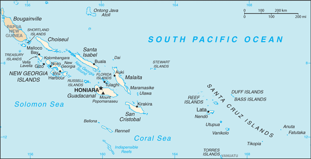
The Solomons archipelago comprises several hundred coral reef islands scattered in the southwestern Pacific. Most of the population live on the six largest islands.
Solomon Islands is mostly rugged mountains with some low coral atolls.
The map above fully covers Solomon Islands with its road routes from cities to towns, road intersections in any region, provinces, prefectures, also with free driving directions in Honiara or to the neighboring towns and countries. To look at the detailed map about a particular quarter in Honiara, please click on the area and zoom to the place you are interested in the Google maps of Solomon Islands (BP).
Be creative, use the extras of this Google map; This is a detailed, clear, zoomable, large road map of Solomon Islands with its administrative divisions; 9 provinces and 1 city*; Central, Choiseul, Guadalcanal, Honiara*, Isabel, Makira and Ulawa, Malaita, Rennell and Bellona, Temotu, Western.
The interactive map above is also may be used as the satellite map of Solomon Islands, or as a reverse search map for finding an address from its GPS coordinates.
A scattered archipelago of about 1,000 mountainous islands and low-lying coral atolls, the Solomon Islands lie east of Papua New Guinea and northeast of Australia in the south Pacific. The islands include Guadalcanal, Malaita, Santa Isabel, San Cristóbal, Choiseul, New Georgia, and the Santa Cruz group.
Solomon Islands (area: 28 896 sq km / 11 156,80 sq mi), where the official language is English, lying in Oceania and using the currency; Solomon Islands dollar (SBD), since 1966, set their clock to UTC+11. That means they are 16 hours ahead of Washington DC during Standard Time in Honiara, the capital. Note to the time difference: N/A.
The climate in Solomon Islands; Northern islands are hot and humid all year round; farther south a cool season develops. NovemberApril wet season brings cyclones.
Geography in a nutshell; The six largest islands are volcanic, mountainous, and thickly forested. Flat coastal plains provide the only cultivable land.
Click here for more detailed information about Solomon Islands.
Driving directions Solomon Islands
The Google maps and Google Satellite maps of Solomon Islands above showing the country, located next to N/A. For your further reference, the latitude and longitude coordinates of Solomon Islands are 8 00 S, 159 00 E , while the capital, Honiara found at 9 26 S 159 57 E.
When you are traveling around Solomon Islands, Honiara, or its other cities, use this routing tool, providing up to date route planning service free of charge.
Look no further; get accurate driving directions in Solomon Islands, Oceania, by filling the route planner form below.
Since Google acquired and introduced its digitalized maps in 2004, you’re probably familiar with its base functions, like finding an address or driving directions to locations. Still, Google maps also accommodate bicyclists, pedestrians, and also public transportation with special directions and customizable routes.
About Solomon Islands and the capital, Honiara
 |
 |
| The national flag of Solomon Islands | Borderline map of Solomon Islands |
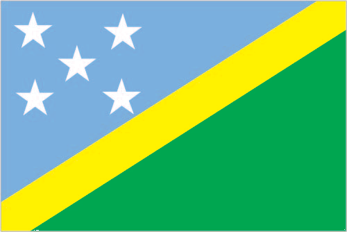
| Flag description: divided diagonally by a thin yellow stripe from the lower hoist-side corner; the upper triangle (hoist side) is blue with five white five-pointed stars arranged in an X pattern; the lower triangle is green; blue represents the ocean; green the land; and yellow sunshine; the five stars stand for the five main island groups of the Solomon Islands. | Border length: 0 km. |
Did you know about Solomon Islands?
- The Solomon Islands were a British colony from 1883, until they became self-governing in 1976, and subsequently independent in 1978.
- The battle for Japanese- held Guadalcanal was the first major US offensive in the Pacific War during World War II.
- The heavily wooded Solomon Islands introduced a sustainable forest-harvesting policy in 1998 to prevent illegal logging and deforestation.
Facts of Solomon Islands (BP)
Name conventional long form: none, conventional short form: Solomon Islands, local long form: none, local short form: Solomon Islands, former: British Solomon Islands, etymology: Spanish explorer Alvaro de MENDANA named the isles in 1568 after the wealthy biblical King SOLOMON in the mistaken belief that the islands contained great riches
Codes: ISO; BP, Internet; .sb
Capital city: Honiara
Language(s): Melanesian pidgin (in much of the country is lingua franca), English (official language but spoken by only 1%-2% of the population), 120 indigenous languages
National holiday(s): Independence Day, 7 July (1978)
Motto: To Lead is to Serve
Currency: Solomon Islands dollar (SBD), since 1966
GPS: 8 00 S, 159 00 E, Honiara; 9 26 S 159 57 E
Location: Oceania, group of islands in the South Pacific Ocean, east of Papua New Guinea
Geography note: strategic location on sea routes between the South Pacific Ocean, the Solomon Sea, and the Coral Sea; on 2 April 2007 an undersea earthquake measuring 8.1 on the Richter scale occurred 345 km WNW of the capital Honiara; the resulting tsunami devastated coastal areas of Western and Choiseul provinces with dozens of deaths and thousands dislocated; the provincial capital of Gizo was especially hard hit
Land boundaries: N/A, 0 km
Maritime boundaries: Coral Sea, Pacific Ocean
Coastline: 5,313 km
Area: total: 28,896 sq km; land: 27,986 sq km, water: 910 sq km (total 11 156,80 mi2), slightly smaller than Maryland.
Roadways: total: 1,390 km, paved: 34 km, unpaved: 1,356 km, note: includes 920 km of private plantation roads (2011)
Waterways: N/A
Local time (capital): UTC+11, 16 hours ahead of Washington DC during Standard Time
Note to the local time: N/A
Population in Solomon Islands: 623 281
Population in Honiara: 68 000 (including the metropolitan areas)
Urbanization: urban population: 22.3% of total population (2015)
Major urban areas population: HONIARA (capital) 73,000 (2014)
Population growth rate: 1.98% (2016 estimate)
Birth rate: 25.3 births / 1,000 population (2016 estimate)
Death rate: 3.8 deaths / 1,000 population (2016 estimate)
Age structure: 0-14 years: 35.13% (male 114,871 / female 108,229) 15-24 years: 20.01% (male 65,349 / female 61,702) 25-54 years: 36.12% (male 116,795 / female 112,564) 55-64 years: 4.55% (male 14,565 / female 14,302) 65 years and over: 4.2% (male 12,701 / female 13,949) (2016 estimate)
Median age: total: 22.2 years; male: 22 years, female: 22.4 years (2016 estimate)
Ethnic groups: Melanesian 95.3%, Polynesian 3.1%, Micronesian 1.2%, other 0.3% (2009 estimate)
Religions: Protestant 73.4% (Church of Melanesia 31.9%, South Sea Evangelical 17.1%, Seventh Day Adventist 11.7%, United Church 10.1%, Christian Fellowship Church 2.5%), Roman Catholic 19.6%, other Christian 2.9%, other 4%, none 0.03%, unspecified 0.1% (2009 estimate)
Government type: Constitutional monarchy
Legal system: mixed legal system of English common law and customary law
National anthem: God Save Our Solomon Islands
Known national hazards: typhoons, but rarely destructive; geologically active region with frequent earthquakes, tremors, and volcanic activity; tsunamisvolcanism: Tinakula (elev. 851 m) has frequent eruption activity, while an eruption of Savo (elev. 485 m) could affect the capital Honiara on nearby Guadalcanal
Major infectious diseases: N/A
Land use: agricultural land: 3.9%; arable land 0.7%; permanent crops 2.9%; permanent pasture 0.3%; forest: 78.9%; other: 17.2% (2011 estimate)
Agricultural products: cocoa, coconuts, palm kernels, rice, fruit; cattle, pigs; fish; timber
Industries: fish (tuna), mining, timber
Export commodities: timber, fish, copra, palm oil, cocoa
Main export partners: China 61.7%, India 5.9%, Italy 5.9% (2015)
Import commodities: food, plant and equipment, manufactured goods, fuels, chemicals
Main import partners: Australia 24.7%, China 18.4%, Malaysia 6.3%, Singapore 5.8%, Fiji 4.7%, NZ 4.6%, Papua New Guinea 4.6% (2015)
Navigate the countries in Oceania faster and easier while driving, use the interactive Google maps for your driving directions. The continuously updated database contains over 220 countries and territories digitally mapped, hundreds of millions of businesses and places around the world positioned on the map.
Get fresh GPS navigation, traffic, and transit information – no matter what part of Solomon Islands, Honiara, any other city and country in Oceania, or the world you’re in.
Do you like this Solomon Islands information page? Please don’t forget to share it with others! Thank you.