Papua New Guinea Google maps and Driving Directions
Get free driving directions, Google maps, traffic information for Papua New Guinea, and Port Moresby (GPS: 9 27 S 147 11 E), the capital city of the country located in (the) Oceania, group of islands including the eastern half of the island of New Guinea between the Coral Sea and the South Pacific Ocean, east of Indonesia.
Find any address in Port Moresby on the Google map of Papua New Guinea (PG) with ease or calculate your up to date itinerary to and from Papua New Guinea or its neighboring counties like Indonesia.
Sightseeing and exploring in Oceania starts here, thanks to Google because its Earth Engine combines a multi-petabyte catalog of updated satellite imagery and geospatial datasets with planetary-scale analysis capabilities. Wonder the world, use the satellite map function of the Google maps to explore or see differences on the Earth’s surface, inland, or the surrounding areas of Papua New Guinea.
Google Maps Papua New Guinea
A former Australian colony, Papua New Guinea (PNG) occupies the eastern section of the island of New Guinea and several other island groups. Much of the country is isolated.
Papua New Guinea is mostly mountains with coastal lowlands and rolling foothills.
The map above fully covers Papua New Guinea with its road routes from cities to towns, road intersections in any region, provinces, prefectures, also with free driving directions in Port Moresby or to the neighboring towns and countries. To look at the detailed map about a particular quarter in Port Moresby, please click on the area and zoom to the place you are interested in the Google maps of Papua New Guinea (PG).
Be creative, use the extras of this Google map; This is a detailed, clear, zoomable, large road map of Papua New Guinea with its administrative divisions; 20 provinces, 1 autonomous region*, and 1 district**; Bougainville*, Central, Chimbu, Eastern Highlands, East New Britain, East Sepik, Enga, Gulf, Hela, Jiwaka, Madang, Manus, Milne Bay, Morobe, National Capital**, New Ireland, Northern, Southern Highlands, Western, Western Highlands, West New Britain, West Sepik.
The interactive map above is also may be used as the satellite map of Papua New Guinea, or as a reverse search map for finding an address from its GPS coordinates.
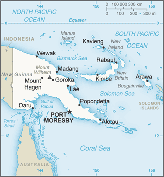
Papua New Guinea occupies the eastern half of the island of New Guinea, just north of Australia, and many outlying islands. The Indonesian province of West Papua (Irian Jaya) is to the west. To the north and east are the islands of Manus, New Britain, New Ireland, and Bougainville, all part of Papua New Guinea. About one-tenth larger than California, its mountainous interior has only recently been explored. Two major rivers, the Sepik and the Fly, are navigable for shallow-draft vessels.
Papua New Guinea (area: 462 840 sq km / 178 703,45 sq mi), where the official language is English, Hiri Motu, Papua New Guinean Sign Language, Tok Pisin, lying in Oceania and using the currency; Papua New Guinean kina (PGK), since 1975, set their clock to UTC+10. That means they are 15 hours ahead of Washington DC during Standard Time in Port Moresby, the capital. Note to the time difference: N/A.
The climate in Papua New Guinea; Hot and humid in lowlands, cooling toward highlands, where snow can fall on highest peaks.
Geography in a nutshell; Mountainous and forested mainland, with broad, swampy river valleys. 40 active volcanoes in the north. Around 600 outer islands.
Click here for more detailed information about Papua New Guinea.
Driving directions Papua New Guinea
The Google maps and Google Satellite maps of Papua New Guinea above showing the country, located next to Indonesia. For your further reference, the latitude and longitude coordinates of Papua New Guinea are 6 00 S, 147 00 E , while the capital, Port Moresby found at 9 27 S 147 11 E.
When you are traveling around Papua New Guinea, Port Moresby, or its other cities, use this routing tool, providing up to date route planning service free of charge.
Look no further; get accurate driving directions in Papua New Guinea, Oceania, by filling the route planner form below.
Since Google acquired and introduced its digitalized maps in 2004, you’re probably familiar with its base functions, like finding an address or driving directions to locations. Still, Google maps also accommodate bicyclists, pedestrians, and also public transportation with special directions and customizable routes.
About Papua New Guinea and the capital, Port Moresby
 |
 |
| The national flag of Papua New Guinea | Borderline map of Papua New Guinea |
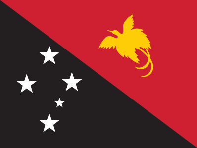
| Flag description: divided diagonally from upper hoist-side corner; the upper triangle is red with a soaring yellow bird of paradise centered; the lower triangle is black with five, white, five-pointed stars of the Southern Cross constellation centered; red, black, and yellow are traditional colors of Papua New Guinea; the bird of paradise – endemic to the island of New Guinea – is an emblem of regional tribal culture and represents the emergence of Papua New Guinea as a nation; the Southern Cross, visible in the night sky, symbolizes Papua New Guinea‘s connection with Australia and several other countries in the South Pacific. | Border length: total: 824 km. Border countries (total: 1): Indonesia 824 km. |
Did you know about Papua New Guinea?
- Papua New Guinea gained full independence in 1975, following its status as a United Nations Trusteeship under Australian administration.
- PNG is home to the only known poisonous birds; contact with the feathers of some species of pitohui produces skin blisters.
- A mostly mountainous country covered with tropical rain forest, Papua New Guinea occupies the eastern end of New Guinea-the worlds third largest island-and includes 600 other small islands, spread out across the Pacific.
Facts of Papua New Guinea (PG)
Name conventional long form: Independent State of Papua New Guinea, conventional short form: Papua New Guinea, local short form: Papuaniugini, former: Territory of Papua and New Guineaabbreviation: PNG, etymology: the word “papua” derives from the Malay “papuah” describing the frizzy hair of the Melanesians; Spanish explorer Ynigo ORTIZ de RETEZ applied the term “Nueva Guinea” to the island of New Guinea in 1545 after noting the resemblance of the locals to the peoples of the Guinea coast of Africa
Codes: ISO; PG, Internet; .pg
Capital city: Port Moresby
Language(s): Tok Pisin (official language), English (official language), Hiri Motu (official language), some 836 indigenous languages spoken (about 12% of the world’s total); most languages have fewer than 1,000 speakers. Note: Tok Pisin, a creole language, is widely used and understood; English is spoken by 1%-2%; Hiri Motu is spoken by less than 2%
National holiday(s): Independence Day, 16 September (1975)
Motto: Unity in diversity
Currency: Papua New Guinean kina (PGK), since 1975
GPS: 6 00 S, 147 00 E, Port Moresby; 9 27 S 147 11 E
Location: Oceania, group of islands including the eastern half of the island of New Guinea between the Coral Sea and the South Pacific Ocean, east of Indonesia
Geography note: shares island of New Guinea with Indonesia; generally east-west trending highlands break up New Guinea into diverse ecoregions; one of world’s largest swamps along southwest coast
Land boundaries: Indonesia 824 km, total: 824 km
Maritime boundaries: N/A
Coastline: 5,152 km
Area: total: 462,840 sq km; land: 452,860 sq km, water: 9,980 sq km (total 178 703,45 mi2), slightly larger than California.
Roadways: total: 9,349 km, paved: 3,000 km, unpaved: 6,349 km (2011)
Waterways: 11,000 km (2011)
Local time (capital): UTC+10, 15 hours ahead of Washington DC during Standard Time
Note to the local time: N/A
Population in Papua New Guinea: 8 418 346
Population in Port Moresby: 343 000 (including the metropolitan areas)
Urbanization: urban population: 13% of total population (2015)
Major urban areas population: PORT MORESBY (capital) 345,000 (2015)
Population growth rate: 1.75% (2016 estimate)
Birth rate: 24 births / 1,000 population (2016 estimate)
Death rate: 6.5 deaths / 1,000 population (2016 estimate)
Age structure: 0-14 years: 33.93% (male 1,173,034 / female 1,131,387) 15-24 years: 19.86% (male 683,474 / female 665,245) 25-54 years: 36.65% (male 1,281,641 / female 1,207,658) 55-64 years: 5.39% (male 185,846 / female 180,255) 65 years and over: 4.16% (male 143,851 / female 138,926) (2016 estimate)
Median age: total: 22.9 years; male: 23 years, female: 22.8 years (2016 estimate)
Ethnic groups: Melanesian, Papuan, Negrito, Micronesian, Polynesian
Religions: Roman Catholic 27%, Protestant 69.4% (Evangelical Lutheran 19.5%, United Church 11.5%, Seventh-Day Adventist 10%, Pentecostal 8.6%, Evangelical Alliance 5.2%, Anglican 3.2%, Baptist 2.5%, other Protestant 8.9%), Baha’i 0.3%, indigenous beliefs and other 3.3% (2000 census)
Government type: Unitary parliamentary constitutional monarchy
Legal system: mixed legal system of English common law and customary law
National anthem: O arise all you sons of this land
Known national hazards: active volcanism; situated along the Pacific “Ring of Fire”; the country is subject to frequent and sometimes severe earthquakes; mud slides; tsunamisvolcanism: severe volcanic activity; Ulawun (elev. 2,334 m), one of Papua New Guinea‘s potentially most dangerous volcanoes, has been deemed a Decade Volcano by the International Association of Volcanology and Chemistry of the Earth’s Interior, worthy of study due to its explosive history and proximity to human populations; Rabaul (elev. 688 m) destroyed the city of Rabaul in 1937 and 1994; Lamington erupted in 1951 killing 3,000 people; Manam’s 2004 eruption forced the island’s abandonment; other historically active volcanoes include Bam, Bagana, Garbuna, Karkar, Langila, Lolobau, Long Island, Pago, St. Andrew Strait, Victory, and Waiowa
Major infectious diseases: The degree of risk(s): very high food or waterborne diseases: bacterial diarrhea, hepatitis A, and typhoid fever vectorborne diseases: dengue fever and malaria. Note: active local transmission of Zika virus by Aedes species mosquitoes has been identified in this country (as of August 2016); it poses an important risk (a large number of cases possible) among US citizens if bitten by an infective mosquito; other less common ways to get Zika are through sex, via blood transfusion, or during pregnancy, in which the pregnant woman passes Zika virus to her fetus (2016)
Land use: agricultural land: 2.6%; arable land 0.7%; permanent crops 1.5%; permanent pasture 0.4%; forest: 63.1%; other: 34.3% (2011 estimate)
Agricultural products: coffee, cocoa, copra, palm kernels, tea, sugar, rubber, sweet potatoes, fruit, vegetables, vanilla; poultry, pork; shellfish
Industries: copra crushing, palm oil processing, plywood production, wood chip production; mining (gold, silver, copper); crude oil and petroleum products; construction, tourism
Export commodities: oil, gold, copper ore, logs, palm oil, coffee, cocoa, crayfish, prawns
Main export partners: Japan 17.4%, Australia 15.9%, China 12.1% (2015)
Import commodities: machinery and transport equipment, manufactured goods, food, fuels, chemicals
Main import partners: Australia 25.9%, China 20%, Singapore 12.6%, Malaysia 7.2%, US 4.2%, Indonesia 4.1%, South Korea 4% (2015)
Navigate the countries in Oceania faster and easier while driving, use the interactive Google maps for your driving directions. The continuously updated database contains over 220 countries and territories digitally mapped, hundreds of millions of businesses and places around the world positioned on the map.
Get fresh GPS navigation, traffic, and transit information – no matter what part of Papua New Guinea, Port Moresby, any other city and country in Oceania, or the world you’re in.
Do you like this Papua New Guinea information page? Please don’t forget to share it with others! Thank you.