Saint Lucia Google maps and Driving Directions
Get free driving directions, Google maps, traffic information for Saint Lucia, and Castries (GPS: 14 00 N 61 00 W), the capital city of the country located in (the) Caribbean, island between the Caribbean Sea and North Atlantic Ocean, north of Trinidad and Tobago.
Find any address in Castries on the Google map of Saint Lucia (LC) with ease or calculate your up to date itinerary to and from Saint Lucia or its neighboring counties like N/A.
Sightseeing and exploring in America starts here, thanks to Google because its Earth Engine combines a multi-petabyte catalog of updated satellite imagery and geospatial datasets with planetary-scale analysis capabilities. Wonder the world, use the satellite map function of the Google maps to explore or see differences on the Earth’s surface, inland, or the surrounding areas of Saint Lucia.
Google Maps Saint Lucia
St. Lucia is one of the most beautiful of the Caribbean Windward Islands. Ruled by France and the UK at different times in its past, the island retains the character of both.
Saint Lucia is volcanic and mountainous with broad, fertile valleys.
The map above fully covers Saint Lucia with its road routes from cities to towns, road intersections in any region, provinces, prefectures, also with free driving directions in Castries or to the neighboring towns and countries. To look at the detailed map about a particular quarter in Castries, please click on the area and zoom to the place you are interested in the Google maps of Saint Lucia (LC).
Be creative, use the extras of this Google map; This is a detailed, clear, zoomable, large road map of Saint Lucia with its administrative divisions; 10 districts; Anse-la-Raye, Canaries, Castries, Choiseul, Dennery, Gros-Islet, Laborie, Micoud, Soufriere, Vieux-Fort.
The interactive map above is also may be used as the satellite map of Saint Lucia, or as a reverse search map for finding an address from its GPS coordinates.
One of the Windward Islands of the eastern Caribbean, St. Lucia lies just south of Martinique. It is of volcanic origin. A chain of wooded mountains runs from north to south and from them flow many streams into fertile valleys.
Saint Lucia (area: 539 sq km / 208,11 sq mi), where the official language is English, lying in America and using the currency; East Caribbean dollar (XCD), since 1965, set their clock to UTC-4. That means they are 1 hour ahead of Washington DC during Standard Time in Castries, the capital. Note to the time difference: N/A.
The climate in Saint Lucia; Tropical, moderated by trade winds. MayOctober wet season brings daily warm showers. Rainfall is highest in the mountains.
Geography in a nutshell; Volcanic and mountainous, with some broad fertile valleys. The Pitons, ancient lava cones, rise from the sea on the forested west coast.
Click here for more detailed information about Saint Lucia.
Driving directions Saint Lucia
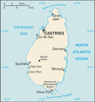
The Google maps and Google Satellite maps of Saint Lucia above showing the country, located next to N/A. For your further reference, the latitude and longitude coordinates of Saint Lucia are 13 53 N, 60 58 W , while the capital, Castries found at 14 00 N 61 00 W.
When you are traveling around Saint Lucia, Castries, or its other cities, use this routing tool, providing up to date route planning service free of charge.
Look no further; get accurate driving directions in Saint Lucia, Central America and the Caribbean, by filling the route planner form below.
Since Google acquired and introduced its digitalized maps in 2004, you’re probably familiar with its base functions, like finding an address or driving directions to locations. Still, Google maps also accommodate bicyclists, pedestrians, and also public transportation with special directions and customizable routes.
About Saint Lucia and the capital, Castries
 |
 |
| The national flag of Saint Lucia | Borderline map of Saint Lucia |
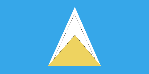
| Flag description: cerulean blue with a gold isosceles triangle below a black arrowhead; the upper edges of the arrowhead have a white border; the blue color represents the sky and sea, gold stands for sunshine and prosperity, and white and black the racial composition of the island (with the latter being dominant); the two major triangles invoke the twin Pitons (Gros Piton and Petit Piton), cone-shaped volcanic plugs that are a symbol of the island. | Border length: 0 km. |
Did you know about Saint Lucia?
- St. Lucia, first settled in 1605, fought over by the French and the British, finally being ceded to Britain in 1814. It became independent in 1979.
- St. Lucia has two Nobel laureates, the most per capita in the world.
- The French were the island’s first European settlers. They signed a treaty with the native Island Caribs in 1660.
Facts of Saint Lucia (LC)
Name conventional long form: none, conventional short form: Saint Lucia, etymology: named after Saint LUCY of Syracuse by French sailors who were shipwrecked on the island on 13 December 1502, the saint’s feast day
Codes: ISO; LC, Internet; .lc
Capital city: Castries
Language(s): English (official language), French patois
National holiday(s): Independence Day, 22 February (1979)
Motto: The Land, The People, The Light
Currency: East Caribbean dollar (XCD), since 1965
GPS: 13 53 N, 60 58 W, Castries; 14 00 N 61 00 W
Location: Caribbean, island between the Caribbean Sea and North Atlantic Ocean, north of Trinidad and Tobago
Geography note: the twin Pitons (Gros Piton and Petit Piton), striking cone-shaped peaks south of Soufriere, are one of the scenic natural highlights of the Caribbean
Land boundaries: N/A, 0 km
Maritime boundaries: Atlantic Ocean, Caribbean Sea
Coastline: 158 km
Area: total: 616 sq km; land: 606 sq km, water: 10 sq km (total 208,11 mi2), three and a half times the size of Washington, DC.
Roadways: total: 1,210 km, paved: 847 km, unpaved: 363 km (2011)
Waterways: N/A
Local time (capital): UTC-4, 1 hour ahead of Washington DC during Standard Time
Note to the local time: N/A
Population in Saint Lucia: 179 667
Population in Castries: 21 000 (including the metropolitan areas)
Urbanization: urban population: 18.5% of total population (2015)
Major urban areas population: CASTRIES (capital) 22,000 (2014)
Population growth rate: 0.33% (2016 estimate)
Birth rate: 13.5 births / 1,000 population (2016 estimate)
Death rate: 7.6 deaths / 1,000 population (2016 estimate)
Age structure: 0-14 years: 20.35% (male 17,225 / female 16,237) 15-24 years: 15.88% (male 13,257 / female 12,867) 25-54 years: 42.97% (male 33,974 / female 36,697) 55-64 years: 9.58% (male 7,278 / female 8,478) 65 years and over: 11.22% (male 8,352 / female 10,099) (2016 estimate)
Median age: total: 34.2 years; male: 33 years, female: 35.3 years (2016 estimate)
Ethnic groups: black/African descent 85.3%, mixed 10.9%, East Indian 2.2%, other 1.6%, unspecified 0.1% (2010 estimate)
Religions: Roman Catholic 61.5%, Protestant 25.5% (includes Seventh Day Adventist 10.4%, Pentecostal 8.9%, Baptist 2.2%, Anglican 1.6%, Church of God 1.5%, other Protestant 0.9%), other Christian 3.4% (includes Evangelical 2.3% and Jehovah’s Witness 1.1%), Rastafarian 1.9%, other 0.4%, none 5.9%, unspecified 1.4% (2010 estimate)
Government type: Constitutional monarchy
Legal system: English common law
National anthem: Sons and Daughters of Saint Lucia
Known national hazards: hurricanes; volcanic activity
Major infectious diseases: note: active local transmission of Zika virus by Aedes species mosquitoes has been identified in this country (as of August 2016); it poses an important risk (a large number of cases possible) among US citizens if bitten by an infective mosquito; other less common ways to get Zika are through sex, via blood transfusion, or during pregnancy, in which the pregnant woman passes Zika virus to her fetus (2016)
Land use: agricultural land: 17.4%; arable land 4.9%; permanent crops 11.5%; permanent pasture 1%; forest: 77%; other: 5.6% (2011 estimate)
Agricultural products: bananas, coconuts, vegetables, citrus, root crops, cocoa
Industries: tourism; clothing, assembly of electronic components, beverages, corrugated cardboard boxes, lime processing, coconut processing
Export commodities: bananas 41%, clothing, cocoa, avocados, mangoes, coconut oil (2010 estimate)
Main export partners: Dominican Republic 25.1%, US 15.9%, Suriname 9.1%, Antigua and Barbuda 7%, Dominica 6.8%, Trinidad and Tobago 6.3%, Barbados 6.1%, UK 4.8%, Grenada 4.6% (2015)
Import commodities: food, manufactured goods, machinery and transportation equipment, chemicals, fuels
Main import partners: Brazil 34.9%, US 25.7%, Trinidad and Tobago 14.4%, Colombia 10.9% (2015)
Navigate the countries in Central America and the Caribbean faster and easier while driving, use the interactive Google maps for your driving directions. The continuously updated database contains over 220 countries and territories digitally mapped, hundreds of millions of businesses and places around the world positioned on the map.
Get fresh GPS navigation, traffic, and transit information – no matter what part of Saint Lucia, Castries, any other city and country in America, or the world you’re in.
Do you like this Saint Lucia information page? Please don’t forget to share it with others! Thank you.