Brunei Google maps and Driving Directions
Get free driving directions, Google maps, traffic information for Brunei, and Bandar Seri Begawan (GPS: 4 53 N 114 56 E), the capital city of the country located in (the) Southeastern Asia, along the northern coast of the island of Borneo, bordering the South China Sea and Malaysia.
Find any address in Bandar Seri Begawan on the Google map of Brunei (BX) with ease or calculate your up to date itinerary to and from Brunei or its neighboring counties like Malaysia.
Sightseeing and exploring in Asia starts here, thanks to Google because its Earth Engine combines a multi-petabyte catalog of updated satellite imagery and geospatial datasets with planetary-scale analysis capabilities. Wonder the world, use the satellite map function of the Google maps to explore or see differences on the Earth’s surface, inland, or the surrounding areas of Brunei.
Google Maps Brunei
Lying on the northern coast of the island of Borneo, Brunei is surrounded and divided in two by the Malaysian state of Sarawak. It has been independent since 1984.
Brunei is flat coastal plain rises to mountains in east; hilly lowland in west.
The map above fully covers Brunei with its road routes from cities to towns, road intersections in any region, provinces, prefectures, also with free driving directions in Bandar Seri Begawan or to the neighboring towns and countries. To look at the detailed map about a particular quarter in Bandar Seri Begawan, please click on the area and zoom to the place you are interested in the Google maps of Brunei (BX).
Be creative, use the extras of this Google map; This is a detailed, clear, zoomable, large road map of Brunei with its administrative divisions; 4 districts (daerah-daerah, singular – daerah); Belait, Brunei-Muara, Temburong, Tutong.
The interactive map above is also may be used as the satellite map of Brunei, or as a reverse search map for finding an address from its GPS coordinates.
About the size of Delaware, Brunei is an independent sultanate on the northwest coast of the island of Borneo in the South China Sea, wedged between the Malaysian states of Sabah and Sarawak.
Brunei (area: 5 765 sq km / 2 225,88 sq mi), where the official language is Malay, lying in Asia and using the currency; Brunei dollar (BND), since 1967, set their clock to UTC+8. That means they are 13 hours ahead of Washington DC during Standard Time in Bandar Seri Begawan, the capital. Note to the time difference: N/A.
The climate in Brunei; Tropical. Six-month rainy season with very high humidity.
Geography in a nutshell; Mostly dense lowland rainforest and mangrove swamps, with some mountains in the southeast.
Click here for more detailed information about Brunei.
Driving directions Brunei
The Google maps and Google Satellite maps of Brunei above showing the country, located next to Malaysia. For your further reference, the latitude and longitude coordinates of Brunei are 4 30 N, 114 40 E , while the capital, Bandar Seri Begawan found at 4 53 N 114 56 E.
When you are traveling around Brunei, Bandar Seri Begawan, or its other cities, use this routing tool, providing up to date route planning service free of charge.
Look no further; get accurate driving directions in Brunei, Southeast Asia, by filling the route planner form below.
Since Google acquired and introduced its digitalized maps in 2004, you’re probably familiar with its base functions, like finding an address or driving directions to locations. Still, Google maps also accommodate bicyclists, pedestrians, and also public transportation with special directions and customizable routes.
About Brunei and the capital, Bandar Seri Begawan
 |
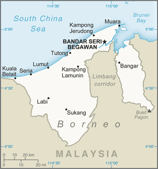 |
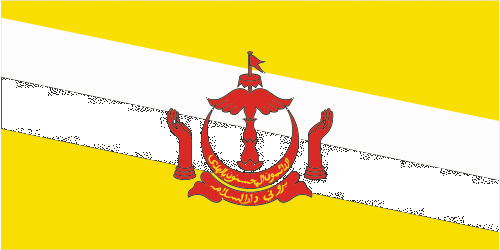
| The national flag of Brunei | Borderline map of Brunei |
| Flag description: yellow with two diagonal bands of white (top, almost double width) and black starting from the upper hoist side; the national emblem in red is superimposed at the center; yellow is the color of royalty and symbolizes the sultanate; the white and black bands denote Brunei’s chief ministers; the emblem includes five main components: a swallow-tailed flag, the royal umbrella representing the monarchy, the wings of four feathers symbolizing justice, tranquility, prosperity, and peace, the two upraised hands signifying the government’s pledge to preserve and promote the welfare of the people, and the crescent moon denoting Islam, the state religion; the state motto “Always render service with God’s guidance” appears in yellow Arabic script on the crescent; a ribbon below the crescent reads “Brunei, the Abode of Peace”. | Border length: total: 266 km. Border countries (total: 1): Malaysia 266 km. |
Did you know about Brunei?
- Brunei became a British Protectorate in 1888. It gained full independence in 1984, and is now an absolute monarchy under its Sultan.
- Tropical. Six-month rainy season with very high humidity.
- Following the discovery of oil underneath this tiny kingdom, Brunei is today one of the worlds richest countries.
Facts of Brunei (BX)
Name conventional long form: Brunei Darussalam, conventional short form: Brunei, local long form: Negara Brunei Darussalam, local short form: Brunei, etymology: derivation of the name is unclear; according to legend, MUHAMMAD SHAH, who would become the first sultan of Brunei, upon discovering what would become Brunei exclaimed “Baru nah,” which roughly translates as “there” or “that’s it”
Codes: ISO; BX, Internet; .bn
Capital city: Bandar Seri Begawan
Language(s): Malay (official language), English, Chinese dialects
National holiday(s): National Day, 23 February (1984)
Motto: Sentiasa membuat kebajikan dengan petunjuk Allah (Always in service with God’s guidance)
Currency: Brunei dollar (BND), since 1967
GPS: 4 30 N, 114 40 E, Bandar Seri Begawan; 4 53 N 114 56 E
Location: Southeastern Asia, along the northern coast of the island of Borneo, bordering the South China Sea and Malaysia
Geography note: close to vital sea lanes through South China Sea linking Indian and Pacific Oceans; two parts physically separated by Malaysia; almost an enclave within Malaysia
Land boundaries: Malaysia 266 km, total: 266 km
Maritime boundaries: N/A
Coastline: 161 km
Area: total: 5,765 sq km; land: 5,265 sq km, water: 500 sq km (total 2 225,88 mi2), slightly smaller than Delaware.
Roadways: total: 3,029 km, paved: 2,425 km, unpaved: 604 km (2010)
Waterways: 209 km (navigable by craft drawing less than 1.2 m; the Belait, Brunei, and Tutong rivers are major transport links) (2012)
Local time (capital): UTC+8, 13 hours ahead of Washington DC during Standard Time
Note to the local time: N/A
Population in Brunei: 434 076
Population in Bandar Seri Begawan: 78 000 (including the metropolitan areas)
Urbanization: urban population: 77.2% of total population (2015)
Major urban areas population: BANDAR SERI BEGAWAN (capital) 241,000 (2011)
Population growth rate: 1.6% (2016 estimate)
Birth rate: 17.2 births / 1,000 population (2016 estimate)
Death rate: 3.6 deaths / 1,000 population (2016 estimate)
Age structure: 0-14 years: 23.46% (male 52,785 / female 49,638) 15-24 years: 17.11% (male 37,103 / female 37,603) 25-54 years: 46.8% (male 98,152 / female 106,206) 55-64 years: 8.09% (male 18,043 / female 17,278) 65 years and over: 4.54% (male 9,635 / female 10,177) (2016 estimate)
Median age: total: 29.9 years; male: 29.5 years, female: 30.3 years (2016 estimate)
Ethnic groups: Malay 65.7%, Chinese 10.3%, other indigenous 3.4%, other 20.6% (2011 estimate)
Religions: Muslim (official) 78.8%, Christian 8.7%, Buddhist 7.8%, other (includes indigenous beliefs) 4.7% (2011 estimate)
Government type: Unitary Islamic absolute monarchy
Legal system: mixed legal system based on English common law and Islamic law; note – in May 2014, the first phase of a sharia-based penal codes was instituted, which applies to Muslims and non-Muslims and exists in parallel to the existing common law-based code
National anthem: Allah Peliharakan Sultan (God Bless the Sultan)
Known national hazards: typhoons, earthquakes, and severe flooding are rare
Major infectious diseases: N/A
Land use: agricultural land: 2.5%; arable land 0.8%; permanent crops 1.1%; permanent pasture 0.6%; forest: 71.8%; other: 25.7% (2011 estimate)
Agricultural products: rice, vegetables, fruits; chickens, water buffalo, cattle, goats, eggs
Industries: petroleum, petroleum refining, liquefied natural gas, construction, agriculture, transportation
Export commodities: mineral fuels, organic chemicals
Main export partners: Japan 35.9%, South Korea 14.8%, Thailand 10.8%, India 9.8%, NZ 5.6%, Australia 5% (2015)
Import commodities: machinery and mechanical appliance parts, mineral fuels, motor vehicles, electric machinery
Main import partners: Singapore 27.9%, China 25.3%, Malaysia 12.4%, UK 10.6%, South Korea 4.9% (2015)
Navigate the countries in Southeast Asia faster and easier while driving, use the interactive Google maps for your driving directions. The continuously updated database contains over 220 countries and territories digitally mapped, hundreds of millions of businesses and places around the world positioned on the map.
Get fresh GPS navigation, traffic, and transit information – no matter what part of Brunei, Bandar Seri Begawan, any other city and country in Asia, or the world you’re in.
Do you like this Brunei information page? Please don’t forget to share it with others! Thank you.