Malaysia Google maps and Driving Directions
Get free driving directions, Google maps, traffic information for Malaysia, and Kuala Lumpur (GPS: 3 10 N 101 42 E), the capital city of the country located in (the) Southeastern Asia, peninsula bordering Thailand and northern one-third of the island of Borneo, bordering Indonesia, Brunei, and the South China Sea, south of Vietnam.
Find any address in Kuala Lumpur on the Google map of Malaysia (MY) with ease or calculate your up to date itinerary to and from Malaysia or its neighboring counties like Brunei, Indonesia, Singapore, Thailand.
Sightseeing and exploring in Asia starts here, thanks to Google because its Earth Engine combines a multi-petabyte catalog of updated satellite imagery and geospatial datasets with planetary-scale analysis capabilities. Wonder the world, use the satellite map function of the Google maps to explore or see differences on the Earth’s surface, inland, or the surrounding areas of Malaysia.
Google Maps Malaysia
Malaysia stretches 1240 miles (2000 km) across southeast Asia from the Malay peninsula to Sabah in eastern Borneo. Federated in 1963, it included Singapore for two years.
Malaysia is coastal plains rising to hills and mountains.
The map above fully covers Malaysia with its road routes from cities to towns, road intersections in any region, provinces, prefectures, also with free driving directions in Kuala Lumpur or to the neighboring towns and countries. To look at the detailed map about a particular quarter in Kuala Lumpur, please click on the area and zoom to the place you are interested in the Google maps of Malaysia (MY).
Be creative, use the extras of this Google map; This is a detailed, clear, zoomable, large road map of Malaysia with its administrative divisions; 13 states (negeri-negeri, singular – negeri); Johor, Kedah, Kelantan, Melaka, Negeri Sembilan, Pahang, Perak, Perlis, Pulau Pinang, Sabah, Sarawak, Selangor, Terengganu; and 1 federal territory (Wilayah Persekutuan) with 3 components, Kuala Lumpur, Labuan, and Putrajaya.
The interactive map above is also may be used as the satellite map of Malaysia, or as a reverse search map for finding an address from its GPS coordinates.
Malaysia is on the Malay Peninsula in southeast Asia. The nation also includes Sabah and Sarawak on the island of Borneo to the east. Its area slightly exceeds that of New Mexico. Most of Malaysia is covered by forest, with a mountain range running the length of the peninsula. Extensive forests provide ebony, sandalwood, teak, and other wood.
Malaysia (area: 330 803 sq km / 127 723,70 sq mi), where the official language is Malaysian, lying in Asia and using the currency; Malaysian ringgit (MYR), since 1967, set their clock to UTC+8. That means they are 13 hours ahead of Washington DC during Standard Time in Kuala Lumpur, the capital. Note to the time difference: N/A.
The climate in Malaysia; Warm equatorial. Rainfall always heavy, but with distinct rainy seasons.
Geography in a nutshell; The Malay Peninsula has central mountains, an eastern coastal belt, and fertile western plains. Swampy coastal plains rise to mountains on Borneo.
Click here for more detailed information about Malaysia.
Driving directions Malaysia
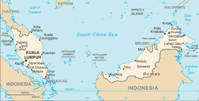
The Google maps and Google Satellite maps of Malaysia above showing the country, located next to Brunei, Indonesia, Singapore, Thailand. For your further reference, the latitude and longitude coordinates of Malaysia are 2 30 N, 112 30 E , while the capital, Kuala Lumpur found at 3 10 N 101 42 E.
When you are traveling around Malaysia, Kuala Lumpur, or its other cities, use this routing tool, providing up to date route planning service free of charge.
Look no further; get accurate driving directions in Malaysia, Southeast Asia, by filling the route planner form below.
Since Google acquired and introduced its digitalized maps in 2004, you’re probably familiar with its base functions, like finding an address or driving directions to locations. Still, Google maps also accommodate bicyclists, pedestrians, and also public transportation with special directions and customizable routes.
About Malaysia and the capital, Kuala Lumpur
 |
 |
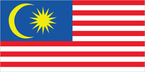
| The national flag of Malaysia | Borderline map of Malaysia |
| Flag description: 14 equal horizontal stripes of red (top) alternating with white (bottom); there is a blue rectangle in the upper hoist-side corner bearing a yellow crescent and a yellow 14-pointed star; the flag is often referred to as Jalur Gemilang (Stripes of Glory); the 14 stripes stand for the equal status in the federation of the 13 member states and the federal government; the 14 points on the star represent the unity between these entities; the crescent is a traditional symbol of Islam; blue symbolizes the unity of the Malay people and yellow is the royal color of Malay rulers. Note: the design is based on the flag of the US. | Border length: total: 2,742 km. Border countries (total: 3): Brunei 266 km, Indonesia 1,881 km, Thailand 595 km. |
Did you know about Malaysia?
- Malaysia became independent of Britain in 1957. In 1963, the Federation of Malaysia formed, although Singapore seceded in 1965.
- Malaysia is southeast Asias major tourist destination, with over 20 million visitors a year.
- Malaysia is one of the worlds top producers of palm oil, from coconuts, used in cooking and to make soap.
Facts of Malaysia (MY)
Name conventional long form: none, conventional short form: Malaysia, local long form: none, local short form: Malaysia, former: Federation of Malaya, etymology: the name means “Land of the Malays”
Codes: ISO; MY, Internet; .my
Capital city: Kuala Lumpur
Language(s): Bahasa Malaysia (official language), English, Chinese (Cantonese, Mandarin, Hokkien, Hakka, Hainan, Foochow), Tamil, Telugu, Malayalam, Panjabi, Thai. Note: in East Malaysia there are several indigenous languages; most widely spoken are Iban and Kadazan
National holiday(s): Independence Day 31 August (1957) (independence of Malaya); Malaysia Day 16 September (1963) (formation of Malaysia)
Motto: Bersekutu Bertambah Mutu (Unity Is Strength)
Currency: Malaysian ringgit (MYR), since 1967
GPS: 2 30 N, 112 30 E, Kuala Lumpur; 3 10 N 101 42 E
Location: Southeastern Asia, peninsula bordering Thailand and northern one-third of the island of Borneo, bordering Indonesia, Brunei, and the South China Sea, south of Vietnam
Geography note: strategic location along Strait of Malacca and southern South China Sea
Land boundaries: Brunei 266 km, Indonesia 1,881 km, Thailand 595 km, total: 2,742 km
Maritime boundaries: N/A
Coastline: 4,675 km (Peninsular Malaysia 2,068 km, East Malaysia 2,607 km)
Area: total: 329,847 sq km; land: 328,657 sq km, water: 1,190 sq km (total 127 723,70 mi2), slightly larger than New Mexico.
Roadways: total: 144,403 km (excludes local roads)paved: 116,169 km (includes 1,821 km of expressways), unpaved: 28,234 km (2010)
Waterways: 7,200 km (Peninsular Malaysia 3,200 km; Sabah 1,500 km; Sarawak 2,500 km) (2011)
Local time (capital): UTC+8, 13 hours ahead of Washington DC during Standard Time
Note to the local time: N/A
Population in Malaysia: 32 042 458
Population in Kuala Lumpur: 3 688 200 (including the metropolitan areas)
Urbanization: urban population: 74.7% of total population (2015)
Major urban areas population: KUALA LUMPUR (capital) 6.837 million; Johor Bahru 912,000 (2015)
Population growth rate: 1.4% (2016 estimate)
Birth rate: 19.4 births / 1,000 population (2016 estimate)
Death rate: 5.1 deaths / 1,000 population (2016 estimate)
Age structure: 0-14 years: 28.16% (male 4,484,188 / female 4,231,557) 15-24 years: 16.86% (male 2,647,105 / female 2,571,883) 25-54 years: 41.06% (male 6,430,455 / female 6,276,427) 55-64 years: 8.06% (male 1,266,415 / female 1,227,690) 65 years and over: 5.86% (male 861,151 / female 953,091) (2016 estimate)
Median age: total: 28.2 years; male: 28 years, female: 28.5 years (2016 estimate)
Ethnic groups: Malay 50.1%, Chinese 22.6%, indigenous 11.8%, Indian 6.7%, other 0.7%, non-citizens 8.2% (2010 estimate)
Religions: Muslim (official) 61.3%, Buddhist 19.8%, Christian 9.2%, Hindu 6.3%, Confucianism, Taoism, other traditional Chinese religions 1.3%, other 0.4%, none 0.8%, unspecified 1% (2010 estimate)
Government type: Constitutional monarchy
Legal system: mixed legal system of English common law, Islamic law, and customary law; judicial review of legislative acts in the Federal Court at request of supreme head of the federation
National anthem: Negaraku (My Country)
Known national hazards: flooding; landslides; forest fires
Major infectious diseases: The degree of risk(s): intermediatefood or waterborne diseases: bacterial diarrheavectorborne diseases: dengue feverwater contact disease: leptospirosis (2016)
Land use: agricultural land: 23.2%; arable land 2.9%; permanent crops 19.4%; permanent pasture 0.9%; forest: 62%; other: 14.8% (2011 estimate)
Agricultural products: Peninsular Malaysia – palm oil, rubber, cocoa, rice; Sabah – palm oil, subsistence crops; rubber, timber; Sarawak – palm oil, rubber, timber; pepper
Industries: Peninsular Malaysia – rubber and oil palm processing and manufacturing, petroleum and natural gas, light manufacturing, pharmaceuticals, medical technology, electronics and semiconductors, timber processing; Sabah – logging, petroleum and natural gas production; Sarawak – agriculture processing, petroleum and natural gas production, logging
Export commodities: semiconductors and electronic equipment, palm oil, petroleum and liquefied natural gas, wood and wood products, palm oil, rubber, textiles, chemicals, solar panels
Main export partners: Singapore 13.9%, China 13%, Japan 9.5%, US 9.4%, Thailand 5.7%, Hong Kong 4.7%, India 4.1% (2015)
Import commodities: electronics, machinery, petroleum products, plastics, vehicles, iron and steel products, chemicals
Main import partners: China 18.8%, Singapore 12%, US 8.1%, Japan 7.8%, Thailand 6.1%, South Korea 4.5%, Indonesia 4.5% (2015)
Navigate the countries in Southeast Asia faster and easier while driving, use the interactive Google maps for your driving directions. The continuously updated database contains over 220 countries and territories digitally mapped, hundreds of millions of businesses and places around the world positioned on the map.
Get fresh GPS navigation, traffic, and transit information – no matter what part of Malaysia, Kuala Lumpur, any other city and country in Asia, or the world you’re in.
Do you like this Malaysia information page? Please don’t forget to share it with others! Thank you.