Belarus Google maps and Driving Directions
Get free driving directions, Google maps, traffic information for Belarus, and Minsk (GPS: 53 54 N 27 34 E), the capital city of the country located in (the) Eastern Europe, east of Poland.
Find any address in Minsk on the Google map of Belarus (BO) with ease or calculate your up to date itinerary to and from Belarus or its neighboring counties like Latvia, Lithuania, Poland, Russia, Ukraine.
Sightseeing and exploring in Europe starts here, thanks to Google because its Earth Engine combines a multi-petabyte catalog of updated satellite imagery and geospatial datasets with planetary-scale analysis capabilities. Wonder the world, use the satellite map function of the Google maps to explore or see differences on the Earth’s surface, inland, or the surrounding areas of Belarus.
Google Maps Belarus
Literally “White Russia,” Belarus lies landlocked in eastern Europe. It reluctantly became independent when the USSR broke up in 1991. It has few resources other than agriculture.
Belarus is generally flat with much marshland.
The map above fully covers Belarus with its road routes from cities to towns, road intersections in any region, provinces, prefectures, also with free driving directions in Minsk or to the neighboring towns and countries. To look at the detailed map about a particular quarter in Minsk, please click on the area and zoom to the place you are interested in the Google maps of Belarus (BO).
Be creative, use the extras of this Google map; This is a detailed, clear, zoomable, large road map of Belarus with its administrative divisions; 6 provinces (voblastsi, singular – voblasts’) and 1 municipality* (horad); Brest, Homyel’ (Gomel’), Horad Minsk* (Minsk City), Hrodna (Grodno), Mahilyow (Mogilev), Minsk, Vitsyebsk (Vitebsk). Note: administrative divisions have the same names as their administrative centers; Russian spelling provided for reference when different from Belarusian.
The interactive map above is also may be used as the satellite map of Belarus, or as a reverse search map for finding an address from its GPS coordinates.
Much of Belarus (formerly the Belorussian Soviet Socialist Republic of the USSR, and then Byelorussia) is a hilly lowland with forests, swamps, and numerous rivers and lakes. There are wide rivers emptying into the Baltic and Black seas. Its forests cover over one-third of the land and its peat marshes are a valuable natural resource. The largest lake is Narach, 31 sq mi (79.6 sq km).
Belarus (area: 207 600 sq km / 80 154,78 sq mi), where the official language is Belarusian, Russian, lying in Europe and using the currency; Belarusian ruble (BYN), since 1993, set their clock to UTC+2. That means they are 7 hours ahead of Washington DC during Standard Time in Minsk, the capital. Note to the time difference: N/A.
The climate in Belarus; Extreme continental climate.Winters are long, sub-freezing, but mainly dry; summers are hot.
Geography in a nutshell; Mainly plains and low hills. The Dnieper and Dvina rivers drain the eastern lowlands. Vast Pripet Marshes in the southwest.
Click here for more detailed information about Belarus.
Driving directions Belarus
The Google maps and Google Satellite maps of Belarus above showing the country, located next to Latvia, Lithuania, Poland, Russia, Ukraine. For your further reference, the latitude and longitude coordinates of Belarus are 53 00 N, 28 00 E , while the capital, Minsk found at 53 54 N 27 34 E.
When you are traveling around Belarus, Minsk, or its other cities, use this routing tool, providing up to date route planning service free of charge.
Look no further; get accurate driving directions in Belarus, Europe, by filling the route planner form below.
Since Google acquired and introduced its digitalized maps in 2004, you’re probably familiar with its base functions, like finding an address or driving directions to locations. Still, Google maps also accommodate bicyclists, pedestrians, and also public transportation with special directions and customizable routes.
About Belarus and the capital, Minsk
 |
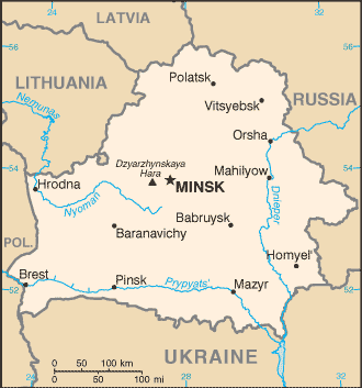 |
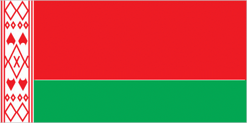
| The national flag of Belarus | Borderline map of Belarus |
| Flag description: red horizontal band (top) and green horizontal band one-half the width of the red band; a white vertical stripe on the hoist side bears Belarusian national ornamentation in red; the red band color recalls past struggles from oppression, the green band represents hope and the many forests of the country. | Border length: total: 3,642 km. Border countries (total: 5): Latvia 161 km, Lithuania 640 km, Poland 418 km, Russia 1,312 km, Ukraine 1,111 km. |
Did you know about Belarus?
- Belarus, formerly White Russia, became independent of the USSR in 1991, although its ties with Russia are increasing once more.
- The number of cancer and leukemia cases soared after the 1986 Chernobyl disaster.
- The Pripet Marshes in southern Belarus are the largest marshlands in Europe and are home to elk and wild boar.
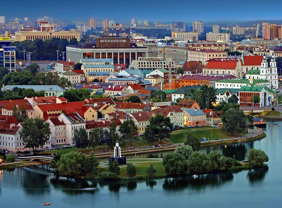
Belarus is a landlocked republic that shares boundaries with Ukraine, Poland, Lithuania, Latvia, and Russia. Most of Belarus is fairly level and low-lying, but it is interrupted by forested hills in the north where there are also several lakes. The west is mainly an area of farmland and forest while the south is a region of marshes drained by many rivers and streams. In the east, there is a slightly higher plain that continues until it meets the low hills of the northeast. Major rivers include the Pripyat and Dnepr and their tributaries. Minsk, the country’s capital and largest city, is located in the center of the country.
Agriculture is one of the country’s most important economic activities, while its timber industry operates on a fairly small scale. Fishing is mainly carried out to supply local needs.
The only abundant natural resource is peat. There are additional small scale deposits of lignite, hard coal and petroleum, but Belarus has to import oil for its domestic needs. Manufactured products include fertilizers, textiles, and vehicles.
Facts of Belarus (BO)
Name conventional long form: Republic of Belarus, conventional short form: Belarus, local long form: Respublika Byelarus’/Respublika Belarus’, local short form: Byelarus’/Belarus’, former: Belorussian (Byelorussian) Soviet Socialist Republic, etymology: the name is a compound of the Belarusian words “bel” (white) and “Rus” (the Old East Slavic ethnic designation) to form the meaning White Rusian or White Ruthenian
Codes: ISO; BO, Internet; .by
Capital city: Minsk
Language(s): Russian (official language) 70.2%, Belarusian (official language) 23.4%, other 3.1% (includes small Polish- and Ukrainian-speaking minorities), unspecified 3.3% (2009 estimate)
National holiday(s): Independence Day, 3 July (1944)
Motto: N/A
Currency: Belarusian ruble (BYN), since 1993
GPS: 53 00 N, 28 00 E, Minsk; 53 54 N 27 34 E
Location: Eastern Europe, east of Poland
Geography note: landlocked country; glacial scouring accounts for the flatness of Belarusian terrain and for its 11,000 lakes
Land boundaries: Latvia 161 km, Lithuania 640 km, Poland 418 km, Russia 1,312 km, Ukraine 1,111 km, total: 3,642 km
Maritime boundaries: N/A
Coastline: 0 km (landlocked country)
Area: total: 207,600 sq km; land: 202,900 sq km, water: 4,700 sq km (total 80 154,78 mi2), slightly less than twice the size of Kentucky; slightly smaller than Kansas.
Roadways: total: 86,392 km, paved: 74,651 km, unpaved: 11,741 km (2010)
Waterways: 2,500 km (major rivers are the west-flowing Western Dvina and Neman rivers and the south-flowing Dnepr River and its tributaries, the Berezina, Sozh, and Pripyat rivers) (2011)
Local time (capital): UTC+2, 7 hours ahead of Washington DC during Standard Time
Note to the local time: N/A
Population in Belarus: 9 452 113
Population in Minsk: 1 769 500 (including the metropolitan areas)
Urbanization: urban population: 76.7% of total population (2015)
Major urban areas population: MINSK (capital) 1.915 million (2015)
Population growth rate: -0.21% (2016 estimate)
Birth rate: 10.5 births / 1,000 population (2016 estimate)
Death rate: 13.3 deaths / 1,000 population (2016 estimate)
Age structure: 0-14 years: 15.65% (male 770,014 / female 727,338) 15-24 years: 10.68% (male 525,704 / female 496,414) 25-54 years: 45.04% (male 2,118,447 / female 2,191,694) 55-64 years: 13.95% (male 589,288 / female 745,815) 65 years and over: 14.69% (male 448,135 / female 957,527) (2016 estimate)
Median age: total: 39.8 years; male: 36.8 years, female: 42.9 years (2016 estimate)
Ethnic groups: Belarusian 83.7%, Russian 8.3%, Polish 3.1%, Ukrainian 1.7%, other 2.4%, unspecified 0.9% (2009 estimate)
Religions: Orthodox 48.3%, Catholic 7.1%, other 3.5%, non-believers 41.1% (2011 estimate)
Government type: Unitary presidential constitutional republic
Legal system: civil law system; note – nearly all major codes (civil, civil procedure, criminal, criminal procedure, family, and labor) have been revised and came into force in 1999 or 2000
National anthem: N/A
Known national hazards: N/A
Major infectious diseases: N/A
Land use: agricultural land: 43.7%; arable land 27.2%; permanent crops 0.6%; permanent pasture 15.9%; forest: 42.7%; other: 13.6% (2011 estimate)
Agricultural products: grain, potatoes, vegetables, sugar beets, flax; beef, milk
Industries: metal-cutting machine tools, tractors, trucks, earthmovers, motorcycles, televisions, synthetic fibers, fertilizer, textiles, radios, refrigerators
Export commodities: machinery and equipment, mineral products, chemicals, metals, textiles, foodstuffs
Main export partners: Russia 39%, UK 11.2%, Ukraine 9.5%, Netherlands 4.3%, Germany 4.1% (2015)
Import commodities: mineral products, machinery and equipment, chemicals, foodstuffs, metals
Main import partners: Russia 56.6%, China 7.9%, Germany 4.6% (2015)
Navigate the countries in Europe faster and easier while driving, use the interactive Google maps for your driving directions. The continuously updated database contains over 220 countries and territories digitally mapped, hundreds of millions of businesses and places around the world positioned on the map.
Get fresh GPS navigation, traffic, and transit information – no matter what part of Belarus, Minsk, any other city and country in Europe, or the world you’re in.
Do you like this Belarus information page? Please don’t forget to share it with others! Thank you.