San Marino Google maps and Driving Directions
Get free driving directions, Google maps, traffic information for San Marino, and San Marino (GPS: 43 56 N 12 25 E), the capital city of the country located in (the) Southern Europe, an enclave in central Italy.
Find any address in San Marino on the Google map of San Marino (SM) with ease or calculate your up to date itinerary to and from San Marino or its neighboring counties like Italy.
Sightseeing and exploring in Europe starts here, thanks to Google because its Earth Engine combines a multi-petabyte catalog of updated satellite imagery and geospatial datasets with planetary-scale analysis capabilities. Wonder the world, use the satellite map function of the Google maps to explore or see differences on the Earth’s surface, inland, or the surrounding areas of San Marino.
Google Maps San Marino
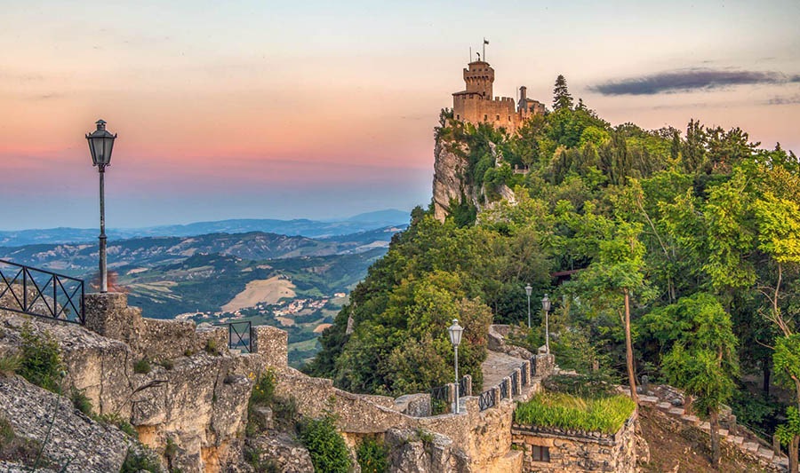
Perched on the slopes of Monte Titano in the Italian Apennines, San Marino has maintained its independence since the 4th century CE, but Italy effectively controls most of its affairs.
San Marino is rugged mountains.
The map above fully covers San Marino with its road routes from cities to towns, road intersections in any region, provinces, prefectures, also with free driving directions in San Marino or to the neighboring towns and countries. To look at the detailed map about a particular quarter in San Marino (city), please click on the area and zoom to the place you are interested in the Google maps of San Marino (SM).
Be creative, use the extras of this Google map; This is a detailed, clear, zoomable, large road map of San Marino with its administrative divisions; 9 municipalities (castelli, singular – castello); Acquaviva, Borgo Maggiore, Chiesanuova, Domagnano, Faetano, Fiorentino, Montegiardino, San Marino Citta, Serravalle.
The interactive map above is also may be used as the satellite map of San Marino, or as a reverse search map for finding an address from its GPS coordinates.
One-tenth the size of New York City, San Marino is surrounded by Italy. It is situated in the Apennines, a little inland from the Adriatic Sea near Rimini.
San Marino (area: 61 sq km / 23,55 sq mi), where the official language is Italian, lying in Europe and using the currency; Euro (EUR), since 1999, set their clock to UTC+1. That means they are 6 hours ahead of Washington DC during Standard Time in San Marino (city), the capital. Note to the time difference: Daylight saving time: +1hr begins last Sunday in March; ends last Sunday in October.
The climate in San Marino; High altitude and sea breezes moderate a Mediterranean climate. Hot summers and cool, wet winters.
Geography in a nutshell; Distinctive limestone outcrop of Monte Titano dominates wooded hills and pastures near Italys Adriatic coast.
Click here for more detailed information about San Marino.
Driving directions San Marino
The Google maps and Google Satellite maps of San Marino above showing the country, located next to Italy. For your further reference, the latitude and longitude coordinates of San Marino are 43 46 N, 12 25 E , while the capital, San Marino (city) found at 43 56 N 12 25 E.
When you are traveling around San Marino, San Marino (city), or its other cities, use this routing tool, providing up to date route planning service free of charge.
Look no further; get accurate driving directions in San Marino, Europe, by filling the route planner form below.
Since Google acquired and introduced its digitalized maps in 2004, you’re probably familiar with its base functions, like finding an address or driving directions to locations. Still, Google maps also accommodate bicyclists, pedestrians, and also public transportation with special directions and customizable routes.
About San Marino and the capital, San Marino
 |
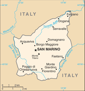 |
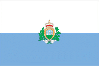
| The national flag of San Marino | Borderline map of San Marino |
| Flag description: two equal horizontal bands of white (top) and light blue with the national coat of arms superimposed in the center; the main colors derive from the shield of the coat of arms, which features three white towers on three peaks on a blue field; the towers represent three castles built on San Marino‘s highest feature, Mount Titano: Guaita, Cesta, and Montale; the coat of arms is flanked by a wreath, below a crown and above a scroll bearing the word LIBERTAS (Liberty); the white and blue colors are also said to stand for peace and liberty respectively. | Border length: total: 37 km. Border countries (total: 1): Italy 37 km. |
Did you know about San Marino?
- Founded in the 4th century, the Republic of San Marino is one of the smallest and oldest in the world. It lies on the slopes of Mt. Titano in Italy.
- Sales of postage stamps and coins contribute around 10% of the national income.
The Republic of San Marino is one of two small, independent enclaves, of which the Vatican City is the second, surrounded by the country of Italy, which survived from the time when almost all of the region consisted of autonomous city-states. Since 1862, as the rest of Italy moved towards unification, San Marino has maintained treaties of friendship with its all-embracing neighbor.
The country has a population of about 25,000 people. The medieval capital, also called San Marino, is built on a hill and is surrounded by ancient, fortified city walls within which several fine, old buildings are preserved.
Facts of San Marino (SM)
Name conventional long form: Republic of San Marino, conventional short form: San Marino, local long form: Repubblica di San Marino, local short form: San Marino, etymology: named after Saint MARINUS, the traditional founder of the country
Codes: ISO; SM, Internet; .sm
Capital city: San Marino
Language(s): Italian
National holiday(s): Founding of the Republic, 3 September (A.D. 301)
Motto: Libertas (Freedom)
Currency: Euro (EUR), since 1999
GPS: 43 46 N, 12 25 E, San Marino; 43 56 N 12 25 E
Location: Southern Europe, an enclave in central Italy
Geography note: landlocked country; smallest independent state in Europe after the Holy See and Monaco; dominated by the Apennine Mountains
Land boundaries: Italy 37 km, total: 37 km
Maritime boundaries: N/A
Coastline: 0 km (landlocked country)
Area: total: 61 sq km; land: 61 sq km, water: 0 sq km (total 23,55 mi2), about one-third the size of Washington, DC.
Roadways: total: 292 km, paved: 292 km (2006)
Waterways: N/A
Local time (capital): UTC+1, 6 hours ahead of Washington DC during Standard Time
Note to the local time: Daylight saving time: +1hr begins last Sunday in March; ends last Sunday in October
Population in San Marino: 33 557
Population in San Marino (city): 4 128 (including the metropolitan areas)
Urbanization: urban population: 94.2% of total population (2015)
Major urban areas population: SAN MARINO 4,000 (2014)
Population growth rate: 0.78% (2016 estimate)
Birth rate: 8.6 births / 1,000 population (2016 estimate)
Death rate: 8.6 deaths / 1,000 population (2016 estimate)
Age structure: 0-14 years: 15.46% (male 2,736 / female 2,410) 15-24 years: 11.34% (male 1,944 / female 1,832) 25-54 years: 41.34% (male 6,480 / female 7,280) 55-64 years: 12.52% (male 2,075 / female 2,092) 65 years and over: 19.34% (male 2,883 / female 3,553) (2016 estimate)
Median age: total: 44.2 years; male: 43.1 years, female: 45.1 years (2016 estimate)
Ethnic groups: Sammarinese, Italian
Religions: Roman Catholic
Government type: Unitary parliamentary directorial republic
Legal system: civil law system with Italian civil law influences
National anthem: Inno nazionale della Repubblica di San Marino (National Anthem of the Republic)
Known national hazards: N/A
Major infectious diseases: N/A
Land use: agricultural land: 16.7%; arable land 16.7%; permanent crops 0%; permanent pasture 0%; forest: 0%; other: 83.3% (2011 estimate)
Agricultural products: wheat, grapes, corn, olives; cattle, pigs, horses, beef, cheese, hides
Industries: tourism, banking, textiles, electronics, ceramics, cement, wine
Export commodities: building stone, lime, wood, chestnuts, wheat, wine, baked goods, hides, ceramics
Main export partners: Italy 82.3% (2012 estimate)
Import commodities: wide variety of consumer manufactures, food, energy
Main import partners: Italy 81.8% (2012 estimate)
Navigate the countries in Europe faster and easier while driving, use the interactive Google maps for your driving directions. The continuously updated database contains over 220 countries and territories digitally mapped, hundreds of millions of businesses and places around the world positioned on the map.
Get fresh GPS navigation, traffic, and transit information – no matter what part of San Marino, San Marino, any other city and country in Europe, or the world you’re in.
Do you like this San Marino information page? Please don’t forget to share it with others! Thank you.