Djibouti Google maps and Driving Directions
Get free driving directions, Google maps, traffic information for Djibouti, and Djibouti (GPS: 11 35 N 43 09 E), the capital city of the country located in (the) Eastern Africa, bordering the Gulf of Aden and the Red Sea, between Eritrea and Somalia.
Find any address in Djibouti on the Google map of Djibouti (DJ) with ease or calculate your up to date itinerary to and from Djibouti or its neighboring counties like Eritrea, Ethiopia, Somalia.
Sightseeing and exploring in Africa starts here, thanks to Google because its Earth Engine combines a multi-petabyte catalog of updated satellite imagery and geospatial datasets with planetary-scale analysis capabilities. Wonder the world, use the satellite map function of the Google maps to explore or see differences on the Earth’s surface, inland, or the surrounding areas of Djibouti.
Google Maps Djibouti
A city-state with a desert hinterland, Djibouti lies in northeast Africa on the Red Sea. Once known as the French Territory of the Afars and Issas, independence came in 1977.
Djibouti is coastal plain and plateau separated by central mountains.
The map above fully covers Djibouti with its road routes from cities to towns, road intersections in any region, provinces, prefectures, also with free driving directions in Djibouti or to the neighboring towns and countries. To look at the detailed map about a particular quarter in Djibouti, please click on the area and zoom to the place you are interested in the Google maps of Djibouti (DJ).
Be creative, use the extras of this Google map; This is a detailed, clear, zoomable, large road map of Djibouti with its administrative divisions; 6 districts (cercles, singular – cercle); Ali Sabieh, Arta, Dikhil, Djibouti, Obock, Tadjourah.
The interactive map above is also may be used as the satellite map of Djibouti, or as a reverse search map for finding an address from its GPS coordinates.
Djibouti lies in northeast Africa on the Gulf of Aden at the southern entrance to the Red Sea. It borders Ethiopia, Eritrea, and Somalia. The country, the size of Massachusetts, is mainly a stony desert, with scattered plateaus and highlands.
Djibouti (area: 23 200 sq km / 8 957,57 sq mi), where the official language is Arabic, French, lying in Africa and using the currency; Djiboutian franc (DJF), since 1977, set their clock to UTC+3. That means they are 8 hours ahead of Washington DC during Standard Time in Djibouti, the capital. Note to the time difference: N/A.
The climate in Djibouti; Almost no rain, though the monsoon is very humid. The 109°F (45°C) heat of summer is unbearable.
Geography in a nutshell; Mainly low-lying desert and semidesert, with a volcanic mountain range in the north.
Click here for more detailed information about Djibouti.
Driving directions Djibouti
The Google maps and Google Satellite maps of Djibouti above showing the country, located next to Eritrea, Ethiopia, Somalia. For your further reference, the latitude and longitude coordinates of Djibouti are 11 30 N, 43 00 E , while the capital, Djibouti found at 11 35 N 43 09 E.
When you are traveling around Djibouti, Djibouti, or its other cities, use this routing tool, providing up to date route planning service free of charge.
Look no further; get accurate driving directions in Djibouti, Africa, by filling the route planner form below.
Since Google acquired and introduced its digitalized maps in 2004, you’re probably familiar with its base functions, like finding an address or driving directions to locations. Still, Google maps also accommodate bicyclists, pedestrians, and also public transportation with special directions and customizable routes.
About Djibouti and the capital, Djibouti
 |
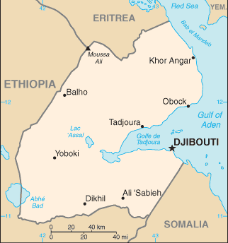 |
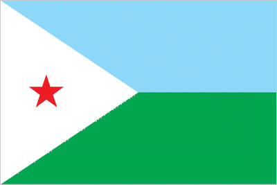
| The national flag of Djibouti | Borderline map of Djibouti |
| Flag description: two equal horizontal bands of light blue (top) and light green with a white isosceles triangle based on the hoist side bearing a red five-pointed star in the center; blue stands for sea and sky and the Issa Somali people; green symbolizes earth and the Afar people; white represents peace; the red star recalls the struggle for independence and stands for unity. | Border length: total: 528 km. Border countries (total: 3): Eritrea 125 km, Ethiopia 342 km, Somalia 61 km. |
Did you know about Djibouti?
- Once known as French Somaliland, and from 1967 as the Territory of the Afars and Issas, Djibouti gained independence in 1977.
- Chewing the leaves of the mildly narcotic qat shrub is an age-old social ritual in Djibouti.
- Unusually, Djibouti is named after its capital city, which is a major port in the Red Sea.
Facts of Djibouti (DJ)
Name conventional long form: Republic of Djibouti, conventional short form: Djibouti, local long form: Republique de Djibouti/Jumhuriyat Jibuti, local short form: Djibouti/Jibuti, former: French Territory of the Afars and Issas, French Somaliland, etymology: the country name derives from the capital city of Djibouti
Codes: ISO; DJ, Internet; .dj
Capital city: Djibouti
Language(s): French (official language), Arabic (official language), Somali, Afar
National holiday(s): Independence Day, 27 June (1977)
Motto: Unité, Égalité, Paix (Unity, Equality, Peace)
Currency: Djiboutian franc (DJF), since 1977
GPS: 11 30 N, 43 00 E, Djibouti; 11 35 N 43 09 E
Location: Eastern Africa, bordering the Gulf of Aden and the Red Sea, between Eritrea and Somalia
Geography note: strategic location near world’s busiest shipping lanes and close to Arabian oilfields; terminus of rail traffic into Ethiopia; mostly wasteland; Lac Assal (Lake Assal) is the lowest point in Africa and the saltiest lake in the world
Land boundaries: Eritrea 125 km, Ethiopia 342 km, Somalia 61 km, total: 528 km
Maritime boundaries: N/A
Coastline: 314 km
Area: total: 23,200 sq km; land: 23,180 sq km, water: 20 sq km (total 8 957,57 mi2), slightly smaller than New Jersey.
Roadways: total: 3,065 km, paved: 1,379 km, unpaved: 1,686 km (2000)
Waterways: N/A
Local time (capital): UTC+3, 8 hours ahead of Washington DC during Standard Time
Note to the local time: N/A
Population in Djibouti: 971 408
Population in Djibouti: 383 000 (including the metropolitan areas)
Urbanization: urban population: 77.3% of total population (2015)
Major urban areas population: DJIBOUTI (capital) 529,000 (2015)
Population growth rate: 2.18% (2016 estimate)
Birth rate: 23.6 births / 1,000 population (2016 estimate)
Death rate: 7.6 deaths / 1,000 population (2016 estimate)
Age structure: 0-14 years: 31.71% (male 134,604 / female 133,840) 15-24 years: 21.54% (male 85,805 / female 96,587) 25-54 years: 38.37% (male 134,945 / female 189,930) 55-64 years: 4.7% (male 18,257 / female 21,538) 65 years and over: 3.68% (male 13,992 / female 17,189) (2016 estimate)
Median age: total: 23.5 years; male: 21.8 years, female: 24.9 years (2016 estimate)
Ethnic groups: Somali 60%, Afar 35%, other 5% (includes French, Arab, Ethiopian, and Italian)
Religions: Muslim 94%, Christian 6%
Government type: Semi-presidential republic
Legal system: mixed legal system based primarily on the French civil code (as it existed in 1997), Islamic religious law (in matters of family law and successions), and customary law
National anthem: Djibouti
Known national hazards: earthquakes; droughts; occasional cyclonic disturbances from the Indian Ocean bring heavy rains and flash floodsvolcanism: experiences limited volcanic activity; Ardoukoba (elev. 298 m) last erupted in 1978; Manda-Inakir, located along the Ethiopian border, is also historically active
Major infectious diseases: The degree of risk(s): high food or waterborne diseases: bacterial and protozoal diarrhea, hepatitis A, and typhoid fever vectorborne disease: dengue fever (2016)
Land use: agricultural land: 73.4%; arable land 0.1%; permanent crops 0%; permanent pasture 73.3%; forest: 0.2%; other: 26.4% (2011 estimate)
Agricultural products: fruits, vegetables; goats, sheep, camels, animal hides
Industries: construction, agricultural processing, shipping
Export commodities: reexports, hides and skins, coffee (in transit), scrap metal
Main export partners: Somalia 79.8%, US 5.4%, Yemen 4.6%, UAE 4% (2015)
Import commodities: foods, beverages, transport equipment, chemicals, petroleum products, clothing
Main import partners: China 42.1%, Saudi Arabia 14.3%, Indonesia 5.9%, India 4.4% (2015)
Navigate the countries in Africa faster and easier while driving, use the interactive Google maps for your driving directions. The continuously updated database contains over 220 countries and territories digitally mapped, hundreds of millions of businesses and places around the world positioned on the map.
Get fresh GPS navigation, traffic, and transit information – no matter what part of Djibouti, Djibouti, any other city and country in Africa, or the world you’re in.
Do you like this Djibouti information page? Please don’t forget to share it with others! Thank you.