Comoros Google maps and Driving Directions
Get free driving directions, Google maps, traffic information for Comoros, and Moroni (GPS: 11 42 S 43 14 E), the capital city of the country located in (the) Southern Africa, group of islands at the northern mouth of the Mozambique Channel, about two-thirds of the way between northern Madagascar and northern Mozambique.
Find any address in Moroni on the Google map of Comoros (CN) with ease or calculate your up to date itinerary to and from Comoros or its neighboring counties like N/A.
Sightseeing and exploring in Africa starts here, thanks to Google because its Earth Engine combines a multi-petabyte catalog of updated satellite imagery and geospatial datasets with planetary-scale analysis capabilities. Wonder the world, use the satellite map function of the Google maps to explore or see differences on the Earth’s surface, inland, or the surrounding areas of Comoros.
Google Maps Comoros
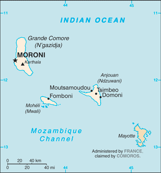
Off the east African coast, between Mozambique and Madagascar, lies the archipelago republic of the Comoros, comprising three main islands and a number of smaller islets.
Comoros is volcanic islands, interiors vary from steep mountains to low hills.
The map above fully covers Comoros with its road routes from cities to towns, road intersections in any region, provinces, prefectures, also with free driving directions in Moroni or to the neighboring towns and countries. To look at the detailed map about a particular quarter in Moroni, please click on the area and zoom to the place you are interested in the Google maps of Comoros (CN).
Be creative, use the extras of this Google map; This is a detailed, clear, zoomable, large road map of Comoros with its administrative divisions; 3 islands and 4 municipalities*; Anjouan (Ndzuwani), Domoni*, Fomboni*, Grande Comore (N’gazidja), Moheli (Mwali), Moroni*, Moutsamoudou*.
The interactive map above is also may be used as the satellite map of Comoros, or as a reverse search map for finding an address from its GPS coordinates.
The Comoros Islands – Grande Comoro (Ngazidja), Anjouan, Mohéli, and Mayotte (which is not part of the country and retains ties to France) – constitute an archipelago of volcanic origin in the Indian Ocean, 190 mi off the coast of Mozambique.
Comoros (area: 2 170 sq km / 837,84 sq mi), where the official language is Arabic, Comorian, French, lying in Africa and using the currency; Comorian franc (KMF), since 1974, set their clock to UTC+3. That means they are 8 hours ahead of Washington DC during Standard Time in Moroni, the capital. Note to the time difference: N/A.
The climate in Comoros; Hot and humid all year round, especially on the coasts. November to May is hottest and wettest period.
Geography in a nutshell; Main islands are of volcanic origin and are heavily forested. The remainder are coral atolls.
Click here for more detailed information about Comoros.
Driving directions Comoros
The Google maps and Google Satellite maps of Comoros above showing the country, located next to N/A. For your further reference, the latitude and longitude coordinates of Comoros are 12 10 S, 44 15 E , while the capital, Moroni found at 11 42 S 43 14 E.
When you are traveling around Comoros, Moroni, or its other cities, use this routing tool, providing up to date route planning service free of charge.
Look no further; get accurate driving directions in Comoros, Africa, by filling the route planner form below.
Since Google acquired and introduced its digitalized maps in 2004, you’re probably familiar with its base functions, like finding an address or driving directions to locations. Still, Google maps also accommodate bicyclists, pedestrians, and also public transportation with special directions and customizable routes.
About Comoros and the capital, Moroni
 |
 |
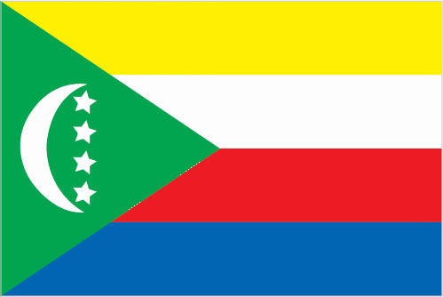
| The national flag of Comoros | Borderline map of Comoros |
| Flag description: four equal horizontal bands of yellow (top), white, red, and blue, with a green isosceles triangle based on the hoist; centered within the triangle is a white crescent with the convex side facing the hoist and four white, five-pointed stars placed vertically in a line between the points of the crescent; the horizontal bands and the four stars represent the four main islands of the archipelago – Mwali, N’gazidja, Ndzuwani, and Mahore (Mayotte – department of France, but claimed by Comoros). Note: the crescent, stars, and color green are traditional symbols of Islam. | Border length: 0 km. |
Did you know about Comoros?
- The Comoros became independent in 1975, although the island of Mayotte did not join the new state and remains a French dependency.
- The Comoros is the worlds largest producer of ylang-ylang an extract from tree blossom used in manufacturing perfumes.
- One of the main crops on the Comoros islands is vanilla, used to flavor ice cream and cakes.
Facts of Comoros (CN)
Name conventional long form: Union of the Comoros, conventional short form: Comoros, local long form: Udzima wa Komori (Comorian); Union des Comores (French); Jumhuriyat al Qamar al Muttahidah (Arabic), local short form: Komori (Comorian); Comores (French); Juzur al Qamar (Arabic), etymology: name derives from the Arabic designation “Juzur al Qamar” meaning “Islands of the Moon”
Codes: ISO; CN, Internet; .km
Capital city: Moroni
Language(s): Arabic (official language), French (official language), Shikomoro (official language; a blend of Swahili and Arabic) (Comorian)
National holiday(s): Independence Day, 6 July (1975)
Motto: Unité, Solidarité, Développement (Unity, Solidarity, Development)
Currency: Comorian franc (KMF), since 1974
GPS: 12 10 S, 44 15 E, Moroni; 11 42 S 43 14 E
Location: Southern Africa, group of islands at the northern mouth of the Mozambique Channel, about two-thirds of the way between northern Madagascar and northern Mozambique
Geography note: important location at northern end of Mozambique Channel
Land boundaries: N/A, 0 km
Maritime boundaries: Indian Ocean
Coastline: 340 km
Area: total: 2,235 sq km; land: 2,235 sq km, water: 0 sq km (total 837,84 mi2), slightly more than 12 times the size of Washington, DC.
Roadways: total: 880 km, paved: 673 km, unpaved: 207 km (2002)
Waterways: N/A
Local time (capital): UTC+3, 8 hours ahead of Washington DC during Standard Time
Note to the local time: N/A
Population in Comoros: 832 347
Population in Moroni: 60 200 (including the metropolitan areas)
Urbanization: urban population: 28.3% of total population (2015)
Major urban areas population: MORONI (capital) 56,000 (2014)
Population growth rate: 1.71% (2016 estimate)
Birth rate: 26.9 births / 1,000 population (2016 estimate)
Death rate: 7.4 deaths / 1,000 population (2016 estimate)
Age structure: 0-14 years: 40.1% (male 158,809 / female 159,840) 15-24 years: 19.23% (male 73,947 / female 78,831) 25-54 years: 32.58% (male 122,936 / female 135,962) 55-64 years: 4.21% (male 14,850 / female 18,611) 65 years and over: 3.89% (male 14,321 / female 16,571) (2016 estimate)
Median age: total: 19.6 years; male: 19 years, female: 20.2 years (2016 estimate)
Ethnic groups: Antalote, Cafre, Makoa, Oimatsaha, Sakalava
Religions: Sunni Muslim 98%, Roman Catholic 2%note: Islam is the state religion
Government type: Federal presidential republic
Legal system: mixed legal system of Islamic religious law, the French civil code of 1975, and customary law
National anthem: Udzima wa ya Masiwa (The Unity of the Great Islands)
Known national hazards: cyclones possible during rainy season (December to April); volcanic activity on Grand Comorevolcanism: Karthala (elev. 2,361 m) on Grand Comore Island last erupted in 2007; a 2005 eruption forced thousands of people to be evacuated and produced a large ash cloud
Major infectious diseases: N/A
Land use: agricultural land: 84.4%; arable land 46.7%; permanent crops 29.6%; permanent pasture 8.1%; forest: 1.4%; other: 14.2% (2011 estimate)
Agricultural products: vanilla, cloves, ylang-ylang (perfume essence), coconuts, bananas, cassava (manioc)
Industries: fishing, tourism, perfume distillation
Export commodities: vanilla, ylang-ylang (perfume essence), cloves
Main export partners: India 28.7%, France 17%, Germany 8.7%, Saudi Arabia 7.1%, Singapore 6.6%, Netherlands 6.1%, Mauritius 5.3% (2015)
Import commodities: rice and other foodstuffs, consumer goods, petroleum products, cement and construction materials, transport equipment
Main import partners: China 18.9%, Pakistan 16.2%, France 14.7%, UAE 11.3%, India 6.3% (2015)
Navigate the countries in Africa faster and easier while driving, use the interactive Google maps for your driving directions. The continuously updated database contains over 220 countries and territories digitally mapped, hundreds of millions of businesses and places around the world positioned on the map.
Get fresh GPS navigation, traffic, and transit information – no matter what part of Comoros, Moroni, any other city and country in Africa, or the world you’re in.
Do you like this Comoros information page? Please don’t forget to share it with others! Thank you.