Seychelles Google maps and Driving Directions
Get free driving directions, Google maps, traffic information for Seychelles, and Victoria (GPS: 4 37 S 55 27 E), the capital city of the country located in (the) archipelago in the Indian Ocean, northeast of Madagascar.
Find any address in Victoria on the Google map of Seychelles (SC) with ease or calculate your up to date itinerary to and from Seychelles or its neighboring counties like N/A.
Sightseeing and exploring in Africa starts here, thanks to Google because its Earth Engine combines a multi-petabyte catalog of updated satellite imagery and geospatial datasets with planetary-scale analysis capabilities. Wonder the world, use the satellite map function of the Google maps to explore or see differences on the Earth’s surface, inland, or the surrounding areas of Seychelles.
Google Maps Seychelles
Formerly a UK colony, the Seychelles comprises 115 islands in the Indian Ocean. After 14 years as a one-party state, multiparty elections were introduced in 1993.
Seychelles is Mahe Group is volcanic with a narrow coastal strip and rocky, hilly interior; others are coral, flat, elevated reefs.
The map above fully covers Seychelles with its road routes from cities to towns, road intersections in any region, provinces, prefectures, also with free driving directions in Victoria or to the neighboring towns and countries. To look at the detailed map about a particular quarter in Victoria, please click on the area and zoom to the place you are interested in the Google maps of Seychelles (SC).
Be creative, use the extras of this Google map; This is a detailed, clear, zoomable, large road map of Seychelles with its administrative divisions; 25 administrative districts; Anse aux Pins, Anse Boileau, Anse Etoile, Anse Royale, Au Cap, Baie Lazare, Baie Sainte Anne, Beau Vallon, Bel Air, Bel Ombre, Cascade, Glacis, Grand Anse Mahe, Grand Anse Praslin, Inner Islands, La Riviere Anglaise, Les Mamalles, Mont Buxton, Mont Fleuri, Plaisance, Pointe Larue, Port Glaud, Roche Caiman, Saint Louis, Takamaka.
The interactive map above is also may be used as the satellite map of Seychelles, or as a reverse search map for finding an address from its GPS coordinates.
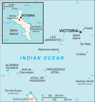
The Seychelles consist of an archipelago of about 100 islands in the Indian Ocean northeast of Madagascar. The principal islands are Mahé (55 sq mi 142 sq km), Praslin (15 sq mi 38 sq km), and La Digue (4 sq mi 10 sq km). The Aldabra, Farquhar, and Desroches groups are included in the territory of the republic.
Seychelles (area: 452 sq km / 174,52 sq mi), where the official language is English, French, Seychellois Creole, lying in Africa and using the currency; Seychellois rupee (SCR), since 1914, set their clock to UTC+4. That means they are 9 hours ahead of Washington DC during Standard Time in Victoria, the capital. Note to the time difference: N/A.
The climate in Seychelles; Tropical oceanic climate. Hot and humid. Rainy season DecemberMay.
Geography in a nutshell; Mostly low-lying coral atolls, but 40, including the largest, Mahé, are mountainous and are the only granitic midocean islands in the world.
Click here for more detailed information about Seychelles.
Driving directions Seychelles
The Google maps and Google Satellite maps of Seychelles above showing the country, located next to N/A. For your further reference, the latitude and longitude coordinates of Seychelles are 4 35 S, 55 40 E , while the capital, Victoria found at 4 37 S 55 27 E.
When you are traveling around Seychelles, Victoria, or its other cities, use this routing tool, providing up to date route planning service free of charge.
Look no further; get accurate driving directions in Seychelles, Africa, by filling the route planner form below.
Since Google acquired and introduced its digitalized maps in 2004, you’re probably familiar with its base functions, like finding an address or driving directions to locations. Still, Google maps also accommodate bicyclists, pedestrians, and also public transportation with special directions and customizable routes.
About Seychelles and the capital, Victoria
 |
 |
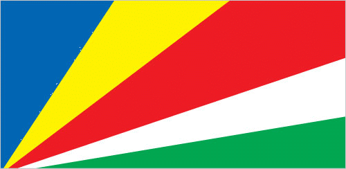
| The national flag of Seychelles | Borderline map of Seychelles |
| Flag description: five oblique bands of blue (hoist side), yellow, red, white, and green (bottom) radiating from the bottom of the hoist side; the oblique bands are meant to symbolize a dynamic new country moving into the future; blue represents sky and sea, yellow the sun giving light and life, red the peoples’ determination to work for the future in unity and love, white social justice and harmony, green the land and natural environment. | Border length: 0 km. |
Did you know about Seychelles?
- The Seychelles became independent from France in 1976. In 1977, a coup détat brought the Seychelles Peoples United Party to power.
- The Seychelles unique species include the coco-de-mer palm, which produces the world’s largest seeds.
- Tourists from around the world are seduced by the Seychelles beaches, scenery, and climate.
Facts of Seychelles (SC)
Name conventional long form: Republic of Seychelles, conventional short form: Seychelles, local long form: Republic of Seychelles, local short form: Seychelles, etymology: named by French Captain Corneille Nicholas MORPHEY after Jean Moreau de SECHELLES, the finance minister of France, in 1756
Codes: ISO; SC, Internet; .sc
Capital city: Victoria
Language(s): Seychellois Creole (official language) 89.1%, English (official language) 5.1%, French (official language) 0.7%, other 3.8%, unspecified 1.4% (2010 estimate)
National holiday(s): Constitution Day, 18 June (1993); Independence Day (National Day), 29 June (1976)
Motto: Finis coronat opus (The End Crowns the Work)
Currency: Seychellois rupee (SCR), since 1914
GPS: 4 35 S, 55 40 E, Victoria; 4 37 S 55 27 E
Location: archipelago in the Indian Ocean, northeast of Madagascar
Geography note: smallest African country; the constitution of the Republic of Seychelles lists 155 islands: 42 granitic and 113 coralline; by far the largest island is Mahe, which is home to about 90% of the population and the site of the capital city of Victoria
Land boundaries: N/A, 0 km
Maritime boundaries: Indian Ocean
Coastline: 491 km
Area: total: 455 sq km; land: 455 sq km, water: 0 sq km (total 174,52 mi2), 2.5 times the size of Washington, DC.
Roadways: total: 526 km, paved: 514 km, unpaved: 12 km (2015)
Waterways: N/A
Local time (capital): UTC+4, 9 hours ahead of Washington DC during Standard Time
Note to the local time: N/A
Population in Seychelles: 95 235
Population in Victoria: 27 000 (including the metropolitan areas)
Urbanization: urban population: 53.9% of total population (2015)
Major urban areas population: VICTORIA (capital) 26,000 (2014)
Population growth rate: 0.8% (2016 estimate)
Birth rate: 13.9 births / 1,000 population (2016 estimate)
Death rate: 6.9 deaths / 1,000 population (2016 estimate)
Age structure: 0-14 years: 20.19% (male 9,650 / female 9,164) 15-24 years: 13.58% (male 6,641 / female 6,016) 25-54 years: 49.36% (male 24,335 / female 21,660) 55-64 years: 9.36% (male 4,483 / female 4,235) 65 years and over: 7.51% (male 2,763 / female 4,239) (2016 estimate)
Median age: total: 34.9 years; male: 34.4 years, female: 35.5 years (2016 estimate)
Ethnic groups: mixed French, African, Indian, Chinese, and Arab
Religions: Roman Catholic 76.2%, Protestant 10.6% (Anglican 6.1%, Pentecoastal Assembly 1.5%, Seventh-Day Adventist 1.2%, other Protestant 1.6), other Christian 2.4%, Hindu 2.4%, Muslim 1.6%, other non-Christian 1.1%, unspecified 4.8%, none 0.9% (2010 estimate)
Government type: Unitary presidential republic
Legal system: mixed legal system of English common law, French civil law, and customary law
National anthem: Koste Seselwa (Join together all Seychellois)
Known national hazards: lies outside the cyclone belt, so severe storms are rare; occasional short droughts
Major infectious diseases: N/A
Land use: agricultural land: 6.5%; arable land 2.2%; permanent crops 4.3%; permanent pasture 0%; forest: 88.5%; other: 5% (2011 estimate)
Agricultural products: coconuts, cinnamon, vanilla, sweet potatoes, cassava (manioc, tapioca), copra, bananas; tuna
Industries: fishing, tourism, beverages
Export commodities: canned tuna, frozen fish, petroleum products (reexports)
Main export partners: France 18.2%, UK 17.9%, Mauritius 10%, Japan 9.2%, Italy 7.8%, Spain 4.5% (2015)
Import commodities: machinery and equipment, foodstuffs, petroleum products, chemicals, other manufactured goods
Main import partners: Saudi Arabia 22.5%, Spain 11.1%, Singapore 7.4%, China 4.5%, South Africa 4.1%, France 4% (2015)
Navigate the countries in Africa faster and easier while driving, use the interactive Google maps for your driving directions. The continuously updated database contains over 220 countries and territories digitally mapped, hundreds of millions of businesses and places around the world positioned on the map.
Get fresh GPS navigation, traffic, and transit information – no matter what part of Seychelles, Victoria, any other city and country in Africa, or the world you’re in.
Do you like this Seychelles information page? Please don’t forget to share it with others! Thank you.