Panama Google maps and Driving Directions
Get free driving directions, Google maps, traffic information for Panama, and Panama City (GPS: 8 58 N 79 32 W), the capital city of the country located in (the) Central America, bordering both the Caribbean Sea and the North Pacific Ocean, between Colombia and Costa Rica.
Find any address in Panama City on the Google map of Panama (PA) with ease or calculate your up to date itinerary to and from Panama or its neighboring counties like Colombia, Costa Rica.
Sightseeing and exploring in America starts here, thanks to Google because its Earth Engine combines a multi-petabyte catalog of updated satellite imagery and geospatial datasets with planetary-scale analysis capabilities. Wonder the world, use the satellite map function of the Google maps to explore or see differences on the Earth’s surface, inland, or the surrounding areas of Panama.
Google Maps Panama
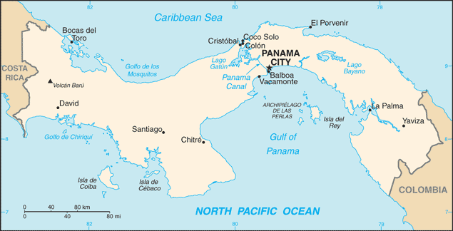
Panama is the southernmost country in Central America. The colossal Panama Canal (which was under US control until 2000) links the Pacific and Atlantic oceans.
Panama is interior mostly steep, rugged mountains with dissected, upland plains; coastal plains with rolling hills.
The map above fully covers Panama with its road routes from cities to towns, road intersections in any region, provinces, prefectures, also with free driving directions in Panama City or to the neighboring towns and countries. To look at the detailed map about a particular quarter in Panama City, please click on the area and zoom to the place you are interested in the Google maps of Panama (PA).
Be creative, use the extras of this Google map; This is a detailed, clear, zoomable, large road map of Panama with its administrative divisions; 10 provinces (provincias, singular – provincia) and 3 indigenous territories* (comarcas); Bocas del Toro, Chiriqui, Cocle, Colon, Darien, Embera-Wounaan*, Herrera, Kuna Yala*, Los Santos, Ngobe-Bugle*, Panama, Panama Oeste, Veraguas.
The interactive map above is also may be used as the satellite map of Panama, or as a reverse search map for finding an address from its GPS coordinates.
The southernmost of the Central American nations, Panama is south of Costa Rica and north of Colombia. The Panama Canal bisects the isthmus at its narrowest and lowest point, allowing passage from the Caribbean Sea to the Pacific Ocean. Panama is slightly smaller than South Carolina. It is marked by a chain of mountains in the west, moderate hills in the interior, and a low range on the east coast. There are extensive forests in the fertile Caribbean area.
Panama (area: 75 417 sq km / 29 118,65 sq mi), where the official language is Spanish, lying in America and using the currency; Panamanian balboa (PAB), since 1904, set their clock to UTC-5. That means they are same time as Washington DC during Standard Time in Panama City, the capital. Note to the time difference: N/A.
The climate in Panama; Hot and humid, with heavy rainfall in the MayDecember wet season. Cooler at high altitudes.
Geography in a nutshell; Lowlands along both coasts, with savanna-covered plains and rolling hills. Mountainous interior. Swamps and rainforests in the east.
Click here for more detailed information about Panama.
Driving directions Panama
The Google maps and Google Satellite maps of Panama above showing the country, located next to Colombia, Costa Rica. For your further reference, the latitude and longitude coordinates of Panama are 9 00 N, 80 00 W , while the capital, Panama City found at 8 58 N 79 32 W.
When you are traveling around Panama, Panama City, or its other cities, use this routing tool, providing up to date route planning service free of charge.
Look no further; get accurate driving directions in Panama, Central America and the Caribbean, by filling the route planner form below.
Since Google acquired and introduced its digitalized maps in 2004, you’re probably familiar with its base functions, like finding an address or driving directions to locations. Still, Google maps also accommodate bicyclists, pedestrians, and also public transportation with special directions and customizable routes.
About Panama and the capital, Panama City
 |
 |
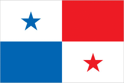
| The national flag of Panama | Borderline map of Panama |
| Flag description: divided into four, equal rectangles; the top quadrants are white (hoist side) with a blue five-pointed star in the center and plain red; the bottom quadrants are plain blue (hoist side) and white with a red five-pointed star in the center; the blue and red colors are those of the main political parties (Conservatives and Liberals respectively) and the white denotes peace between them; the blue star stands for the civic virtues of purity and honesty, the red star signifies authority and law. | Border length: total: 687 km. Border countries (total: 2): Colombia 339 km, Costa Rica 348 km. |
About Panama City
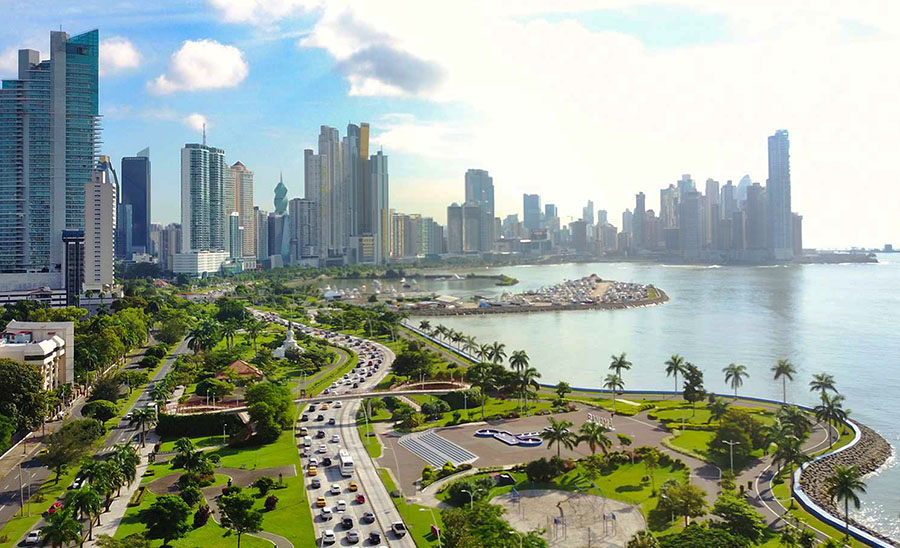
Long overshadowed by the Panama Canal and with a reputation as a hub for drug running, Panama City is not only reinventing itself as the thriving commercial and financial hub of the Americas but becoming a burgeoning tourist destination. Panama City (commonly referred to only as “Panama”) is one of those rare Central American capitals that has it all: a relatively high standard of living, a seemingly endless supply of investment from abroad, a surplus of natural beauty, and a rich cultural brew of ethnicities and religions. There is a sizable ex-pat presence in the city, as well as a growing Asian community, both of which continue to change the face of Panama City.
Did you know about Panama?
- Panama, originally a province of Colombia, was detached in 1903 to secure the building of the Panama Canal within a US-controlled zone.
- The Panama Canal shortens the sea route between the east coast of the US and Japan by 3000 miles (4800 km).
- Long, thin Panama is the most southerly country in Central America, forming a land link to South America. Its climate is hot and humid with heavy rainfall, enabling a wide range of crops to be grown in its fertile soil.
Panama is a narrow, S-shaped isthmus that links Central and South America. It is only about 177 kilometers or 110 miles across at its widest point. Most of the country is mountainous although the peaks are modest by Central American standards. The economy depends on a wide variety of industries including the production of coffee, sugar cane, bananas, maize, beans, rice, some cattle ranching, fishing, timber production, manufacturing, and oil refining.
The Panama Canal, which provides a route for ships between the Caribbean and Atlantic and the Pacific, has ensured the strategic importance of the country, particularly to its powerful neighbor, the USA.
Facts of Panama (PA)
Name conventional long form: Republic of Panama, conventional short form: Panama, local long form: Republica de Panama, local short form: Panama, etymology: according to tradition, the name derives from a former indigenous fishing village and its nearby beach that were called “Panama” meaning “an abundance of fish”
Codes: ISO; PA, Internet; .pa
Capital city: Panama City
Language(s): Spanish (official language), indigenous languages (including Ngabere (or Guaymi), Buglere, Kuna, Embera, Wounaan, Naso (or Teribe), and Bri Bri), Panamanian English Creole (similar to Jamaican English Creole; a mixture of English and Spanish with elements of Ngabere; also known as Guari Guari and Colon Creole), English, Chinese (Yue and Hakka), Arabic, French Creole, other (Yiddish, Hebrew, Korean, Japanese). Note: many Panamanians are bilingual
National holiday(s): Independence Day, 3 November (1903)
Motto: Pro Mundi Beneficio (For the Benefit of the World)
Currency: Panamanian balboa (PAB), since 1904
GPS: 9 00 N, 80 00 W, Panama City; 8 58 N 79 32 W
Location: Central America, bordering both the Caribbean Sea and the North Pacific Ocean, between Colombia and Costa Rica
Geography note: strategic location on eastern end of isthmus forming land bridge connecting North and South America; controls Panama Canal that links North Atlantic Ocean via Caribbean Sea with North Pacific Ocean
Land boundaries: Colombia 339 km, Costa Rica 348 km, total: 687 km
Maritime boundaries: N/A
Coastline: 2,490 km
Area: total: 75,420 sq km; land: 74,340 sq km, water: 1,080 sq km (total 29 118,65 mi2), slightly smaller than South Carolina.
Roadways: total: 15,137 km, paved: 6,351 km, unpaved: 8,786 km (2010)
Waterways: 800 km (includes the 82-km Panama Canal that is being widened) (2011)
Local time (capital): UTC-5, same time as Washington DC during Standard Time
Note to the local time: N/A
Population in Panama: 4 162 618
Population in Panama City: 1 426 000 (including the metropolitan areas)
Urbanization: urban population: 66.6% of total population (2015)
Major urban areas population: PANAMA CITY (capital) 1.673 million (2015)
Population growth rate: 1.3% (2016 estimate)
Birth rate: 18.1 births / 1,000 population (2016 estimate)
Death rate: 4.9 deaths / 1,000 population (2016 estimate)
Age structure: 0-14 years: 26.7% (male 504,990 / female 484,338) 15-24 years: 17.11% (male 323,034 / female 311,099) 25-54 years: 40.31% (male 756,400 / female 737,205) 55-64 years: 7.72% (male 141,582 / female 144,414) 65 years and over: 8.16% (male 138,922 / female 163,262) (2016 estimate)
Median age: total: 28.9 years; male: 28.5 years, female: 29.3 years (2016 estimate)
Ethnic groups: mestizo (mixed Amerindian and white) 65%, Native American 12.3% (Ngabe 7.6%, Kuna 2.4%, Embera 0.9%, Bugle 0.8%, other 0.4%, unspecified 0.2%), black or African descent 9.2%, mulatto 6.8%, white 6.7% (2010 estimate)
Religions: Roman Catholic 85%, Protestant 15%
Government type: Unitary presidential constitutional republic
Legal system: civil law system; judicial review of legislative acts in the Supreme Court of Justice
National anthem: Himno Istmeno (Hymn of the Isthmus)
Known national hazards: occasional severe storms and forest fires in the Darien area
Major infectious diseases: The degree of risk(s): intermediatefood or waterborne diseases: bacterial diarrheavectorborne disease: dengue fever. Note: active local transmission of Zika virus by Aedes species mosquitoes has been identified in this country (as of August 2016); it poses an important risk (a large number of cases possible) among US citizens if bitten by an infective mosquito; other less common ways to get Zika are through sex, via blood transfusion, or during pregnancy, in which the pregnant woman passes Zika virus to her fetus (2016)
Land use: agricultural land: 30.5%; arable land 7.3%; permanent crops 2.5%; permanent pasture 20.7%; forest: 43.6%; other: 25.9% (2011 estimate)
Agricultural products: bananas, rice, corn, coffee, sugarcane, vegetables; livestock; shrimp
Industries: construction, brewing, cement and other construction materials, sugar milling
Export commodities: fruit and nuts, fish, iron and steel waste, wood
Main export partners: US 19.7%, Germany 13.2%, Costa Rica 7.7%, China 5.9%, Netherlands 4.1% (2015)
Import commodities: fuels, machinery, vehicles, iron and steel rods, pharmaceuticals
Main import partners: US 25.9%, China 9.6%, Mexico 5.1% (2015)
Navigate the countries in Central America and the Caribbean faster and easier while driving, use the interactive Google maps for your driving directions. The continuously updated database contains over 220 countries and territories digitally mapped, hundreds of millions of businesses and places around the world positioned on the map.
Get fresh GPS navigation, traffic, and transit information – no matter what part of Panama, Panama City, any other city and country in America, or the world you’re in.
Do you like this Panama information page? Please don’t forget to share it with others! Thank you.