Palau Google maps and Driving Directions
Get free driving directions, Google maps, traffic information for Palau, and Melekeok (GPS: 7 30 N 134 37 E), the capital city of the country located in (the) Oceania, group of islands in the North Pacific Ocean, southeast of the Philippines.
Find any address in Melekeok on the Google map of Palau (PW) with ease or calculate your up to date itinerary to and from Palau or its neighboring counties like N/A.
Sightseeing and exploring in Oceania starts here, thanks to Google because its Earth Engine combines a multi-petabyte catalog of updated satellite imagery and geospatial datasets with planetary-scale analysis capabilities. Wonder the world, use the satellite map function of the Google maps to explore or see differences on the Earth’s surface, inland, or the surrounding areas of Palau.
Google Maps Palau
The 300-island Palau archipelago (known locally as Belau) lies in the western Pacific Ocean. It achieved independence in 1994, and is gradually reducing its aid dependence.
Palau is varying topography from the high, mountainous main island of Babelthuap to low, coral islands usually fringed by large barrier reefs.
The map above fully covers Palau with its road routes from cities to towns, road intersections in any region, provinces, prefectures, also with free driving directions in Melekeok or to the neighboring towns and countries. To look at the detailed map about a particular quarter in Ngerulmud, please click on the area and zoom to the place you are interested in the Google maps of Palau (PW).
Be creative, use the extras of this Google map; This is a detailed, clear, zoomable, large road map of Palau with its administrative divisions; 16 states; Aimeliik, Airai, Angaur, Hatohobei, Kayangel, Koror, Melekeok, Ngaraard, Ngarchelong, Ngardmau, Ngatpang, Ngchesar, Ngeremlengui, Ngiwal, Peleliu, Sonsorol.
The interactive map above is also may be used as the satellite map of Palau, or as a reverse search map for finding an address from its GPS coordinates.
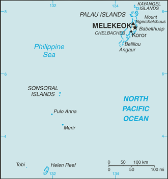
The Palau island chain consists of about 200 islands located in the western Pacific Ocean, 528 mi (650 km) southeast of the Philippines. Only eight of the islands are permanently inhabited. They vary geologically from the high, mountainous, largest island, Babelthuap, to low coral islands, usually fringed by large barrier reefs.
Palau (area: 459 sq km / 177,22 sq mi), where the official language is English, Palauan, lying in Oceania and using the currency; United States dollar (USD), set their clock to UTC+9. That means they are 14 hours ahead of Washington DC during Standard Time in Ngerulmud, the capital. Note to the time difference: N/A.
The climate in Palau; Hot and wet. Little variation in daily and seasonal temperatures. FebruaryApril is the dry season.
Geography in a nutshell; Terrain varies from thickly forested mountains to limestone and coral reefs. Babeldaob, the largest island, is volcanic, with many rivers and waterfalls.
Click here for more detailed information about Palau.
Driving directions Palau
The Google maps and Google Satellite maps of Palau above showing the country, located next to N/A. For your further reference, the latitude and longitude coordinates of Palau are 7 30 N, 134 30 E , while the capital, Ngerulmud found at 7 30 N 134 37 E.
When you are traveling around Palau, Ngerulmud, or its other cities, use this routing tool, providing up to date route planning service free of charge.
Look no further; get accurate driving directions in Palau, Oceania, by filling the route planner form below.
Since Google acquired and introduced its digitalized maps in 2004, you’re probably familiar with its base functions, like finding an address or driving directions to locations. Still, Google maps also accommodate bicyclists, pedestrians, and also public transportation with special directions and customizable routes.
About Palau and the capital, Melekeok
 |
 |
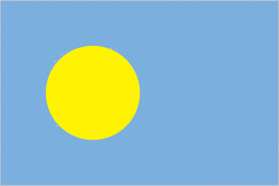
| The national flag of Palau | Borderline map of Palau |
| Flag description: light blue with a large yellow disk shifted slightly to the hoist side; the blue color represents the ocean, the disk represents the moon; Palauans consider the full moon to be the optimum time for human activity; it is also considered a symbol of peace, love, and tranquility. | Border length: 0 km. |
Did you know about Palau?
- Under US control since 1945, Palau became a republic in 1981. In 1994, it became independent in association with the United States.
- Palaus reefs contain 1500 species of fish and 700 types of coral.
- With an abundance of palm trees, Palaus islanders harvest coconuts for their copra- the dried kernel or nut that is made into coconut oil.
Facts of Palau (PW)
Name conventional long form: Republic of Palau, conventional short form: Palau, local long form: Beluu er a Belau, local short form: Belau, former: Trust Territory of the Pacific Islands, Palau District, etymology: from the Palauan name for the islands, Belau, which likely derives from the Palauan word “beluu” meaning “village”
Codes: ISO; PW, Internet; .pw
Capital city: Melekeok
Language(s): Palauan (official language on most islands) 66.6%, Carolinian 0.7%, other Micronesian 0.7%, English (official language) 15.5%, Filipino 10.8%, Chinese 1.8%, other Asian 2.6%, other 1.3%. Note: Sonsoral (Sonsoralese and English are official language), Tobi (Tobi and English are official language), and Angaur (Angaur, Japanese, and English are official language) (2005 estimate)
National holiday(s): Constitution Day, 9 July (1981), day of a national referendum to pass the new constitution; Independence Day, 1 October (1994)
Motto: N/A
Currency: United States dollar (USD)
GPS: 7 30 N, 134 30 E, Melekeok; 7 30 N 134 37 E
Location: Oceania, group of islands in the North Pacific Ocean, southeast of the Philippines
Geography note: westernmost archipelago in the Caroline chain, consists of six island groups totaling more than 300 islands; includes World War II battleground of Beliliou (Peleliu) and world-famous rock islands
Land boundaries: N/A, 0 km
Maritime boundaries: Pacific Ocean
Coastline: 1,519 km
Area: total: 459 sq km; land: 459 sq km, water: 0 sq km (total 177,22 mi2), slightly more than 2.5 times the size of Washington, DC.
Roadways: N/A
Waterways: N/A
Local time (capital): UTC+9, 14 hours ahead of Washington DC during Standard Time
Note to the local time: N/A
Population in Palau: 21 964
Population in Ngerulmud: 1 000 (including the metropolitan areas)
Urbanization: urban population: 87.1% of total population (2015)
Major urban areas population: MELEKEOK (capital) 299 (2012)
Population growth rate: 0.39% (2016 estimate)
Birth rate: 11.2 births / 1,000 population (2016 estimate)
Death rate: 8 deaths / 1,000 population (2016 estimate)
Age structure: 0-14 years: 19.93% (male 2,196 / female 2,059) 15-24 years: 17.02% (male 1,814 / female 1,819) 25-54 years: 46.03% (male 5,997 / female 3,829) 55-64 years: 9.35% (male 697 / female 1,299) 65 years and over: 7.67% (male 429 / female 1,208) (2016 estimate)
Median age: total: 33.3 years; male: 32.7 years, female: 34.7 years (2016 estimate)
Ethnic groups: Palauan (Micronesian with Malayan and Melanesian admixtures) 72.5%, Carolinian 1%, other Micronesian 2.4%, Filipino 16.3%, Chinese 1.6%, Vietnamese 1.6%, other Asian 3.4%, white 0.9%, other 0.3% (2005 estimate)
Religions: Roman Catholic 49.4%, Protestant 30.9% (includes Protestant (general) 23.1%, Seventh Day Adventist 5.3%, and other Protestant 2.5%), Modekngei 8.7% (indigenous to Palau), Jehovah’s Witnesses 1.1%, other 8.8%, none or unspecified 1.1% (2005 estimate)
Government type: Unitary presidential constitutional republic
Legal system: mixed legal system of civil, common, and customary law
National anthem: Belau rekid (Our Palau)
Known national hazards: typhoons (June to December)
Major infectious diseases: N/A
Land use: agricultural land: 10.8%; arable land 2.2%; permanent crops 4.3%; permanent pasture 4.3%; forest: 87.6%; other: 1.6% (2011 estimate)
Agricultural products: coconuts, copra, cassava (manioc, tapioca), sweet potatoes; fish
Industries: tourism, craft items (from shell, wood, pearls), construction, garment making
Export commodities: shellfish, tuna, copra, garments
Main export partners: N/A
Import commodities: machinery and equipment, fuels, metals; foodstuffs
Main import partners: N/A
Navigate the countries in Oceania faster and easier while driving, use the interactive Google maps for your driving directions. The continuously updated database contains over 220 countries and territories digitally mapped, hundreds of millions of businesses and places around the world positioned on the map.
Get fresh GPS navigation, traffic, and transit information – no matter what part of Palau, Melekeok, any other city and country in Oceania, or the world you’re in.
Do you like this Palau information page? Please don’t forget to share it with others! Thank you.