United Arab Emirates Google maps and Driving Directions
Get free driving directions, Google maps, traffic information for United Arab Emirates, and Abu Dhabi (GPS: 24 28 N 54 22 E), the capital city of the country located in (the) Middle East, bordering the Gulf of Oman and the Persian Gulf, between Oman and Saudi Arabia.
Find any address in Abu Dhabi on the Google map of United Arab Emirates (AE) with ease or calculate your up to date itinerary to and from United Arab Emirates or its neighboring counties like Oman, Saudi Arabia.
Sightseeing and exploring in Asia starts here, thanks to Google because its Earth Engine combines a multi-petabyte catalog of updated satellite imagery and geospatial datasets with planetary-scale analysis capabilities. Wonder the world, use the satellite map function of the Google maps to explore or see differences on the Earth’s surface, inland, or the surrounding areas of United Arab Emirates.
Google Maps United Arab Emirates
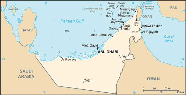
Bordering the Gulf on the northern coast of the Arabian Peninsula, the seven states of the UAE are Abu Dhabi, Dubai, Sharjah, Ajman, Umm al Qaywayn, Ras al Khaymah, and Fujayrah.
United Arab Emirates is flat, barren coastal plain merging into rolling sand dunes of vast desert; mountains in east.
The map above fully covers United Arab Emirates with its road routes from cities to towns, road intersections in any region, provinces, prefectures, also with free driving directions in Abu Dhabi or to the neighboring towns and countries. To look at the detailed map about a particular quarter in Abu Dhabi, please click on the area and zoom to the place you are interested in the Google maps of United Arab Emirates (AE).
Be creative, use the extras of this Google map; This is a detailed, clear, zoomable, large road map of United Arab Emirates with its administrative divisions; 7 emirates (imarat, singular – imarah); Abu Zaby (Abu Dhabi), ‘Ajman, Al Fujayrah, Ash Shariqah (Sharjah), Dubayy (Dubai), Ra’s al Khaymah, Umm al Qaywayn.
The interactive map above is also may be used as the satellite map of United Arab Emirates, or as a reverse search map for finding an address from its GPS coordinates.
The United Arab Emirates, in the eastern part of the Arabian Peninsula, extends along part of the Gulf of Oman and the southern coast of the Persian Gulf. The nation is the size of Maine. Its neighbors are Saudi Arabia to the west and south, Qatar to the north, and Oman to the east. Most of the land is barren and sandy.
United Arab Emirates (area: 83 600 sq km / 32 278,13 sq mi), where the official language is Arabic, lying in Asia and using the currency; United Arab Emirates dirham (AED), since 1973, set their clock to UTC+4. That means they are 9 hours ahead of Washington DC during Standard Time in Abu Dhabi, the capital. Note to the time difference: N/A.
The climate in United Arab Emirates; Summers are humid, despite minimal rainfall. Sand-laden shamalwinds blow in winter and spring.
Geography in a nutshell; Mostly flat, semiarid desert with dunes, salt pans, and occasional oases. Cities are watered by extensive irrigation systems.
Click here for more detailed information about United Arab Emirates.
Driving directions United Arab Emirates
The Google maps and Google Satellite maps of United Arab Emirates above showing the country, located next to Oman, Saudi Arabia. For your further reference, the latitude and longitude coordinates of United Arab Emirates are 24 00 N, 54 00 E , while the capital, Abu Dhabi found at 24 28 N 54 22 E.
When you are traveling around United Arab Emirates, Abu Dhabi, or its other cities, use this routing tool, providing up to date route planning service free of charge.
Look no further; get accurate driving directions in United Arab Emirates, Middle East, by filling the route planner form below.
[xyz-ihs snippet=”routing”]
Since Google acquired and introduced its digitalized maps in 2004, you’re probably familiar with its base functions, like finding an address or driving directions to locations. Still, Google maps also accommodate bicyclists, pedestrians, and also public transportation with special directions and customizable routes.
About United Arab Emirates and the capital, Abu Dhabi
 |
 |
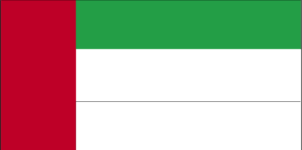
| The national flag of United Arab Emirates | Borderline map of United Arab Emirates |
| Flag description: three equal horizontal bands of green (top), white, and black with a wider vertical red band on the hoist side; the flag incorporates all four Pan-Arab colors, which in this case represent fertility (green), neutrality (white), petroleum resources (black), and unity (red); red was the traditional color incorporated into all flags of the emirates before their unification. | Border length: total: 1,066 km. Border countries (total: 2): Oman 609 km, Saudi Arabia 457 km. |
Did you know about United Arab Emirates?
- The United Arab Emirates is an amalgamation of seven emirates, formerly known as the Trucial States, that came together in 1971.
- Mina Jabal Ali, in Dubai, is the largest man-made port in the world.
- In 1971 seven separate emirates came together to form a single, federated country: the UAE. One of the emirates-Dubai-has built extraordinary fan-shaped developments in the sea to attract foreign tourists.
Facts of United Arab Emirates (AE)
Name conventional long form: United Arab Emirates, conventional short form: none, local long form: Al Imarat al Arabiyah al Muttahidah, local short form: none, former: Trucial Oman, Trucial Statesabbreviation: UAE, etymology: self-descriptive country name; the name “Arabia” can be traced back many centuries B.C., the ancient Egyptians referred to the region as “Ar Rabi”; “emirates” derives from “amir” the Arabic word for “commander,” “lord,” or “prince”
Codes: ISO; AE, Internet; .ae
Capital city: Abu Dhabi
Language(s): Arabic (official language), Persian, English, Hindi, Urdu
National holiday(s): Independence Day, 2 December (1971)
Motto: N/A
Currency: United Arab Emirates dirham (AED), since 1973
GPS: 24 00 N, 54 00 E, Abu Dhabi; 24 28 N 54 22 E
Location: Middle East, bordering the Gulf of Oman and the Persian Gulf, between Oman and Saudi Arabia
Geography note: strategic location along southern approaches to Strait of Hormuz, a vital transit point for world crude oil
Land boundaries: Oman 609 km, Saudi Arabia 457 km, total: 1,066 km
Maritime boundaries: Gulf of Oman, Persian Gulf
Coastline: 1,318 km
Area: total: 83,600 sq km; land: 83,600 sq km, water: 0 sq km (total 32 278,13 mi2), slightly larger than South Carolina; slightly smaller than Maine.
Roadways: total: 4,080 km, paved: 4,080 km (includes 253 km of expressways) (2008)
Waterways: N/A
Local time (capital): UTC+4, 9 hours ahead of Washington DC during Standard Time
Note to the local time: N/A
Population in United Arab Emirates: 9 541 615
Population in Abu Dhabi: 942 000 (including the metropolitan areas)
Urbanization: urban population: 85.5% of total population (2015)
Major urban areas population: Dubai 2.415 million; Sharjah 1.279 million; ABU DHABI (capital) 1.145 million (2015)
Population growth rate: 2.47% (2016 estimate)
Birth rate: 15.3 births / 1,000 population (2016 estimate)
Death rate: 2 deaths / 1,000 population (2016 estimate)
Age structure: 0-14 years: 20.94% (male 634,996 / female 605,985) 15-24 years: 13.53% (male 476,813 / female 324,982) 25-54 years: 61.27% (male 2,767,886 / female 863,816) 55-64 years: 3.23% (male 142,661 / female 48,715) 65 years and over: 1.04% (male 38,444 / female 23,184) (2016 estimate)
Median age: total: 30.3 years; male: 32.1 years, female: 25.1 years (2016 estimate)
Ethnic groups: Emirati 19%, other Arab and Iranian 23%, South Asian 50%, other expatriates (includes Westerners and East Asians) 8%
Religions: Muslim (official) 76%, Christian 9%, other (primarily Hindu and Buddhist, less than 5% of the population consists of Parsi, Baha’i, Druze, Sikh, Ahmadi, Ismaili, Dawoodi Bohra Muslim, and Jewish) 15%note: represents the total population; about 85% of the population consists of noncitizens (2005 estimate)
Government type: Federal absolute monarchy
Legal system: mixed legal system of Islamic law and civil law
National anthem: Long Live my Nation
Known national hazards: frequent sand and dust storms
Major infectious diseases: N/A
Land use: agricultural land: 4.6%; arable land 0.5%; permanent crops 0.5%; permanent pasture 3.6%; forest: 3.8%; other: 91.6% (2011 estimate)
Agricultural products: dates, vegetables, watermelons; poultry, eggs, dairy products; fish
Industries: petroleum and petrochemicals; fishing, aluminum, cement, fertilizers, commercial ship repair, construction materials, handicrafts, textiles
Export commodities: crude oil 45%, natural gas, reexports, dried fish, dates (2012 estimate)
Main export partners: Iran 14.5%, Japan 9.8%, India 9.2%, China 4.7%, Oman 4.3% (2015)
Import commodities: machinery and transport equipment, chemicals, food
Main import partners: China 15.7%, India 12.8%, US 9.7%, Germany 6.8%, UK 4.4% (2015)
Navigate the countries in Middle East faster and easier while driving, use the interactive Google maps for your driving directions. The continuously updated database contains over 220 countries and territories digitally mapped, hundreds of millions of businesses and places around the world positioned on the map.
Get fresh GPS navigation, traffic, and transit information – no matter what part of United Arab Emirates, Abu Dhabi, any other city and country in Asia, or the world you’re in.
Do you like this United Arab Emirates information page? Please don’t forget to share it with others! Thank you.