Saint Kitts and Nevis Google maps and Driving Directions
Get free driving directions, Google maps, traffic information for Saint Kitts and Nevis, and Basseterre (GPS: 17 18 N 62 43 W), the capital city of the country located in (the) Caribbean, islands in the Caribbean Sea, about one-third of the way from Puerto Rico to Trinidad and Tobago.
Find any address in Basseterre on the Google map of Saint Kitts and Nevis (KN) with ease or calculate your up to date itinerary to and from Saint Kitts and Nevis or its neighboring counties like N/A.
Sightseeing and exploring in America starts here, thanks to Google because its Earth Engine combines a multi-petabyte catalog of updated satellite imagery and geospatial datasets with planetary-scale analysis capabilities. Wonder the world, use the satellite map function of the Google maps to explore or see differences on the Earth’s surface, inland, or the surrounding areas of Saint Kitts and Nevis.
Google Maps Saint Kitts and Nevis
A popular Caribbean tourist destination, St. Kitts and Nevis lies in the northern part of the Leeward Island chain. Nevis is the smaller and less developed of the two islands.
Saint Kitts and Nevis is volcanic with mountainous interiors.
The map above fully covers Saint Kitts and Nevis with its road routes from cities to towns, road intersections in any region, provinces, prefectures, also with free driving directions in Basseterre or to the neighboring towns and countries. To look at the detailed map about a particular quarter in Basseterre, please click on the area and zoom to the place you are interested in the Google maps of Saint Kitts and Nevis (KN).
Be creative, use the extras of this Google map; This is a detailed, clear, zoomable, large road map of Saint Kitts and Nevis with its administrative divisions; 14 parishes; Christ Church Nichola Town, Saint Anne Sandy Point, Saint George Basseterre, Saint George Gingerland, Saint James Windward, Saint John Capesterre, Saint John Figtree, Saint Mary Cayon, Saint Paul Capesterre, Saint Paul Charlestown, Saint Peter Basseterre, Saint Thomas Lowland, Saint Thomas Middle Island, Trinity Palmetto Point.
The interactive map above is also may be used as the satellite map of Saint Kitts and Nevis, or as a reverse search map for finding an address from its GPS coordinates.
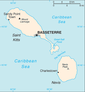
St. Kitts, the larger of the two islands, is roughly oval in shape except for a long, narrow peninsula to the southeast. Its highest point is Mount Liamuiga (3,792 ft [1,156 m]). The Narrows, a 2-mile- (3-km-) wide channel, separates the two islands. The circularly shaped Nevis is surrounded by coral reefs and the island is almost entirely a single mountain, Nevis Peak (3,232 ft [985 m]). A volcanic mountain chain dominates the center of both islands.
Saint Kitts and Nevis (area: 261 sq km / 100,77 sq mi), where the official language is English, lying in America and using the currency; East Caribbean dollar (XCD), since 1965, set their clock to UTC-4. That means they are 1 hour ahead of Washington DC during Standard Time in Basseterre, the capital. Note to the time difference: N/A.
The climate in Saint Kitts and Nevis; Tropical, tempered by trade winds. Little seasonal variation in temperature. Moderate rainfall.
Geography in a nutshell; Volcanic in origin, with forested, mountainous interiors. Nevis has hot and cold springs.
Click here for more detailed information about Saint Kitts and Nevis.
Driving directions Saint Kitts and Nevis
The Google maps and Google Satellite maps of Saint Kitts and Nevis above showing the country, located next to N/A. For your further reference, the latitude and longitude coordinates of Saint Kitts and Nevis are 17 20 N, 62 45 W , while the capital, Basseterre found at 17 18 N 62 43 W.
When you are traveling around Saint Kitts and Nevis, Basseterre, or its other cities, use this routing tool, providing up to date route planning service free of charge.
Look no further; get accurate driving directions in Saint Kitts and Nevis, Central America and the Caribbean, by filling the route planner form below.
Since Google acquired and introduced its digitalized maps in 2004, you’re probably familiar with its base functions, like finding an address or driving directions to locations. Still, Google maps also accommodate bicyclists, pedestrians, and also public transportation with special directions and customizable routes.
About Saint Kitts and Nevis and the capital, Basseterre
 |
 |
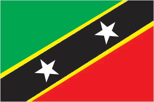
| The national flag of Saint Kitts and Nevis | Borderline map of Saint Kitts and Nevis |
| Flag description: divided diagonally from the lower hoist side by a broad black band bearing two white, five-pointed stars; the black band is edged in yellow; the upper triangle is green, the lower triangle is red; green signifies the island’s fertility, red symbolizes the struggles of the people from slavery, yellow denotes year-round sunshine, and black represents the African heritage of the people; the white stars stand for the islands of Saint Kitts and Nevis, but can also express hope and liberty, or independence and optimism. | Border length: 0 km. |
Did you know about Saint Kitts and Nevis?
- A British colony in the Leeward Islands since 1873,the islands of St. Kitts and Nevis gained independence together in 1983.
- Nevis has been renownedas a spa since the 18th century, and is known as the “Queen of the Caribbean.
- Saint Kitts and Nevis were among the first islands in the Caribbean to be colonized by Europeans.
Facts of Saint Kitts and Nevis (KN)
Name conventional long form: Federation of Saint Kitts and Nevis, conventional short form: Saint Kitts and Nevis, former: Federation of Saint Christopher and Nevis, etymology: Saint Kitts was, and still is, referred to as Saint Christopher and this name was well established by the 17th century (although who first applied the name is unclear); in the 17th century a common nickname for Christopher was Kit or Kitt, so the island began to be referred to as “Saint Kitt’s Island” or just “Saint Kitts”; Nevis is derived from the original Spanish name “Nuestra Senora de las Nieves” (Our Lady of the Snows) and refers to the white halo of clouds that generally wreathes Nevis Peak
Codes: ISO; KN, Internet; .kn
Capital city: Basseterre
Language(s): English (official language)
National holiday(s): Independence Day, 19 September (1983)
Motto: Country Above Self
Currency: East Caribbean dollar (XCD), since 1965
GPS: 17 20 N, 62 45 W, Basseterre; 17 18 N 62 43 W
Location: Caribbean, islands in the Caribbean Sea, about one-third of the way from Puerto Rico to Trinidad and Tobago
Geography note: smallest country in the Americas and Western Hemisphere; with coastlines in the shape of a baseball bat and ball, the two volcanic islands are separated by a 3-km-wide channel called The Narrows; on the southern tip of long, baseball bat-shaped Saint Kitts lies the Great Salt Pond; Nevis Peak sits in the center of its almost circular namesake island and its ball shape complements that of its sister island
Land boundaries: N/A, 0 km
Maritime boundaries: Caribbean Sea
Coastline: 135 km
Area: total: 261 sq km; land: 261 sq km, water: 0 sq km (total 100,77 mi2), 1.5 times the size of Washington, DC.
Roadways: total: 383 km, paved: 163 km, unpaved: 220 km (2002)
Waterways: N/A
Local time (capital): UTC-4, 1 hour ahead of Washington DC during Standard Time
Note to the local time: N/A
Population in Saint Kitts and Nevis: 55 850
Population in Basseterre: 12 000 (including the metropolitan areas)
Urbanization: urban population: 32% of total population (2015)
Major urban areas population: BASSETERRE (capital) 14,000 (2014)
Population growth rate: 0.75% (2016 estimate)
Birth rate: 13.3 births / 1,000 population (2016 estimate)
Death rate: 7.1 deaths / 1,000 population (2016 estimate)
Age structure: 0-14 years: 20.61% (male 5,408 / female 5,379) 15-24 years: 14.82% (male 3,767 / female 3,987) 25-54 years: 44.85% (male 12,028 / female 11,443) 55-64 years: 11.38% (male 2,972 / female 2,983) 65 years and over: 8.34% (male 2,000 / female 2,362) (2016 estimate)
Median age: total: 34.5 years; male: 34.7 years, female: 34.3 years (2016 estimate)
Ethnic groups: predominantly black; some British, Portuguese, and Lebanese
Religions: Anglican, other Protestant, Roman Catholic
Government type: Constitutional monarchy
Legal system: English common law
National anthem: O Land of Beauty!
Known national hazards: hurricanes (July to October)
Major infectious diseases: N/A
Land use: agricultural land: 23.1%; arable land 19.2%; permanent crops 0.4%; permanent pasture 3.5%; forest: 42.3%; other: 34.6% (2011 estimate)
Agricultural products: sugarcane, rice, yams, vegetables, bananas; fish
Industries: tourism, cotton, salt, copra, clothing, footwear, beverages
Export commodities: machinery, food, electronics, beverages, tobacco
Main export partners: US 44.4%, Poland 14.6%, Bangladesh 10.1%, Azerbaijan 4.3% (2015)
Import commodities: machinery, manufactures, food, fuels
Main import partners: US 37.7%, Trinidad and Tobago 22.7%, Barbados 4.4% (2015)
Navigate the countries in Central America and the Caribbean faster and easier while driving, use the interactive Google maps for your driving directions. The continuously updated database contains over 220 countries and territories digitally mapped, hundreds of millions of businesses and places around the world positioned on the map.
Get fresh GPS navigation, traffic, and transit information – no matter what part of Saint Kitts and Nevis, Basseterre, any other city and country in America, or the world you’re in.
Do you like this Saint Kitts and Nevis information page? Please don’t forget to share it with others! Thank you.