Kiribati Google maps and Driving Directions
Get free driving directions, Google maps, traffic information for Kiribati, and Tarawa (GPS: 1 21 N 173 02 E), the capital city of the country located in (the) Oceania, group of 33 coral atolls in the Pacific Ocean, straddling the Equator; the capital Tarawa is about halfway between Hawaii and Australia.
Find any address in Tarawa on the Google map of Kiribati (KI) with ease or calculate your up to date itinerary to and from Kiribati or its neighboring counties like N/A.
Sightseeing and exploring in Oceania starts here, thanks to Google because its Earth Engine combines a multi-petabyte catalog of updated satellite imagery and geospatial datasets with planetary-scale analysis capabilities. Wonder the world, use the satellite map function of the Google maps to explore or see differences on the Earth’s surface, inland, or the surrounding areas of Kiribati.
Google Maps Kiribati
Situated in the mid-Pacific, the islands adopted the name Kiribati (pronounced “Keer-ee-bus, a corruption of their former name “Gilberts) upon independence from Britain in 1979.
Kiribati is mostly low-lying coral atolls surrounded by extensive reefs.
The map above fully covers Kiribati with its road routes from cities to towns, road intersections in any region, provinces, prefectures, also with free driving directions in Tarawa or to the neighboring towns and countries. To look at the detailed map about a particular quarter in Tarawa, please click on the area and zoom to the place you are interested in the Google maps of Kiribati (KI).
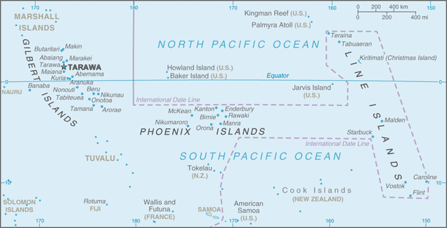
Be creative, use the extras of this Google map; This is a detailed, clear, zoomable, large road map of Kiribati with its administrative divisions; 3 geographical units: Gilbert Islands, Line Islands, Phoenix Islands; note – there are no first-order administrative divisions but there are 6 districts (Banaba, Central Gilberts, Line Islands, Northern Gilberts, Southern Gilberts, Tarawa) and 21 island councils – one for each of the inhabited islands (Abaiang, Abemama, Aranuka, Arorae, Banaba, Beru, Butaritari, Kanton, Kiritimati, Kuria, Maiana, Makin, Marakei, Nikunau, Nonouti, Onotoa, Tabiteuea, Tabuaeran, Tamana, Tarawa, Teraina).
The interactive map above is also may be used as the satellite map of Kiribati, or as a reverse search map for finding an address from its GPS coordinates.
Kiribati, formerly the Gilbert Islands, consists of three widely separated main groups of southwest Pacific islands: the Gilberts on the equator, the Phoenix Islands to the east, and the Line Islands farther east. Ocean Island, producer of phosphates until it was mined out in 1981, is also included in the 2 million square miles of ocean. Most of the islands of Kiribati are low-lying coral atolls built on a submerged volcanic chain and encircled by reefs.
Kiribati (area: 726 sq km / 280,31 sq mi), where the official language is English, Gilbertese, lying in Oceania and using the currency; Australian dollar (AUD), since 1966, set their clock to UTC+12. That means they are 17 hours ahead of Washington DC during Standard Time in Tarawa, the capital. Note to the time difference: On 1 January 1995 Kiribati proclaimed that all of its territory was in the same time zone as its Gilbert Islands group.
The climate in Kiribati; Central islands have a maritime equatorial climate. Those to north and south are tropical, with constant high temperatures. There is little rainfall.
Geography in a nutshell; Kiribati consists of three groups of tiny, very low-lying coral atolls scattered across 1,930,000 sq. miles (5 million sq. km) of ocean. Most of the 33 atolls have central lagoons.
Click here for more detailed information about Kiribati.
Driving directions Kiribati
The Google maps and Google Satellite maps of Kiribati above showing the country, located next to N/A. For your further reference, the latitude and longitude coordinates of Kiribati are 1 25 N, 173 00 E , while the capital, Tarawa found at 1 21 N 173 02 E.
When you are traveling around Kiribati, Tarawa, or its other cities, use this routing tool, providing up to date route planning service free of charge.
Look no further; get accurate driving directions in Kiribati, Oceania, by filling the route planner form below.
Since Google acquired and introduced its digitalized maps in 2004, you’re probably familiar with its base functions, like finding an address or driving directions to locations. Still, Google maps also accommodate bicyclists, pedestrians, and also public transportation with special directions and customizable routes.
About Kiribati and the capital, Tarawa
 |
 |
| The national flag of Kiribati | Borderline map of Kiribati |
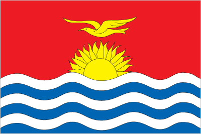
| Flag description: the upper half is red with a yellow frigatebird flying over a yellow rising sun, and the lower half is blue with three horizontal wavy white stripes to represent the Pacific ocean; the white stripes represent the three island groups – the Gilbert, Line, and Phoenix Islands; the 17 rays of the sun represent the 16 Gilbert Islands and Banaba (formerly Ocean Island); the frigatebird symbolizes authority and freedom. | Border length: 0 km. |
Did you know about Kiribati?
- Once part of the British colony of the Gilbert and Ellice Islands, the Gilberts became independent in 1979 and adopted the name Kiribati.
- In 1981, the UK paid A$10 million to Banabans for the destruction of their island by mining.
- Like many Pacific nations, Kiribatis farmers harvest the coconut and use every part of it: copra for oil, and coir fibers for ropes, mats, and brushes.
Facts of Kiribati (KI)
Name conventional long form: Republic of Kiribati, conventional short form: Kiribati, local long form: Republic of Kiribati, local short form: Kiribati. Note: pronounced keer-ree-bahss, former: Gilbert Islands, etymology: the name is the local pronounciation of “Gilberts,” the former designation of the islands; originally named after explorer Thomas GILBERT, who mapped many of the islands in 1788
Codes: ISO; KI, Internet; .ki
Capital city: Tarawa
Language(s): I-Kiribati, English (official language)
National holiday(s): Independence Day, 12 July (1979)
Motto: Te Mauri, Te Raoi ao Te Tabomoa (Health, Peace and Prosperity)
Currency: Australian dollar (AUD), since 1966
GPS: 1 25 N, 173 00 E, Tarawa; 1 21 N 173 02 E
Location: Oceania, group of 33 coral atolls in the Pacific Ocean, straddling the Equator; the capital Tarawa is about halfway between Hawaii and Australia
Geography note: 21 of the 33 islands are inhabited; Banaba (Ocean Island) in Kiribati is one of the three great phosphate rock islands in the Pacific Ocean – the others are Makatea in French Polynesia, and Nauru; Kiribati is the only country in the world to fall into all four hemispheres (northern, southern, eastern, and western)
Land boundaries: N/A, 0 km
Maritime boundaries: Pacific Ocean
Coastline: 1,143 km
Area: total: 811 sq km; land: 811 sq km, water: 0 sq km (total 280,31 mi2), four times the size of Washington, DC.
Roadways: total: 670 km (2011)
Waterways: 5 km (small network of canals in Line Islands) (2012)
Local time (capital): UTC+12, 17 hours ahead of Washington DC during Standard Time
Note to the local time: On 1 January 1995 Kiribati proclaimed that all of its territory was in the same time zone as its Gilbert Islands group
Population in Kiribati: 118 414
Population in Tarawa: 26 600 (including the metropolitan areas)
Urbanization: urban population: 44.3% of total population (2015)
Major urban areas population: TARAWA (capital) 46,000 (2014)
Population growth rate: 1.14% (2016 estimate)
Birth rate: 21.3 births / 1,000 population (2016 estimate)
Death rate: 7.1 deaths / 1,000 population (2016 estimate)
Age structure: 0-14 years: 30.16% (male 16,438 / female 15,814) 15-24 years: 21.26% (male 11,285 / female 11,447) 25-54 years: 38.59% (male 19,863 / female 21,397) 55-64 years: 5.86% (male 2,827 / female 3,436) 65 years and over: 4.13% (male 1,741 / female 2,677) (2016 estimate)
Median age: total: 24.3 years; male: 23.4 years, female: 25.1 years (2016 estimate)
Ethnic groups: I-Kiribati 89.5%, I-Kiribati/mixed 9.7%, Tuvaluan 0.1%, other 0.8% (2010 estimate)
Religions: Roman Catholic 55.8%, Kempsville Presbyterian Church 33.5%, Mormon 4.7%, Baha’i 2.3%, Seventh Day Adventist 2%, other 1.5%, none 0.2%, unspecified 0.05% (2010 estimate)
Government type: Parliamentary republic
Legal system: English common law supplemented by customary law
National anthem: Teirake Kaini Kiribati (Stand up, Kiribati)
Known national hazards: typhoons can occur any time, but usually November to March; occasional tornadoes; low level of some of the islands make them sensitive to changes in sea level
Major infectious diseases: N/A
Land use: agricultural land: 42%; arable land 2.5%; permanent crops 39.5%; permanent pasture 0%; forest: 15%; other: 43% (2011 estimate)
Agricultural products: copra, breadfruit, fish
Industries: fishing, handicrafts
Export commodities: fish, coconut products
Main export partners: N/A
Import commodities: food, machinery and equipment, miscellaneous manufactured goods, fuel
Main import partners: N/A
Navigate the countries in Oceania faster and easier while driving, use the interactive Google maps for your driving directions. The continuously updated database contains over 220 countries and territories digitally mapped, hundreds of millions of businesses and places around the world positioned on the map.
Get fresh GPS navigation, traffic, and transit information – no matter what part of Kiribati, Tarawa, any other city and country in Oceania, or the world you’re in.
Do you like this Kiribati information page? Please don’t forget to share it with others! Thank you.