Tuvalu Google maps and Driving Directions
Get free driving directions, Google maps, traffic information for Tuvalu, and Funafuti (GPS: 8 31 S 179 13 E), the capital city of the country located in (the) Oceania, island group consisting of nine coral atolls in the South Pacific Ocean, about half way from Hawaii to Australia.
Find any address in Funafuti on the Google map of Tuvalu (TV) with ease or calculate your up to date itinerary to and from Tuvalu or its neighboring counties like N/A.
Sightseeing and exploring in Oceania starts here, thanks to Google because its Earth Engine combines a multi-petabyte catalog of updated satellite imagery and geospatial datasets with planetary-scale analysis capabilities. Wonder the world, use the satellite map function of the Google maps to explore or see differences on the Earth’s surface, inland, or the surrounding areas of Tuvalu.
Google Maps Tuvalu
One of the worlds smallest, most isolated states, Tuvalu lies in the central Pacific. The nine islands were linked to the Gilbert Islands (Kiribati) as a UK colony until independence.
Tuvalu is low-lying and narrow coral atolls.
The map above fully covers Tuvalu with its road routes from cities to towns, road intersections in any region, provinces, prefectures, also with free driving directions in Funafuti or to the neighboring towns and countries. To look at the detailed map about a particular quarter in Funafuti, please click on the area and zoom to the place you are interested in the Google maps of Tuvalu (TV).
Be creative, use the extras of this Google map; This is a detailed, clear, zoomable, large road map of Tuvalu with its administrative divisions; 7 island councils and 1 town council*; Funafuti*, Nanumaga, Nanumea, Niutao, Nui, Nukufetau, Nukulaelae, Vaitupu.
The interactive map above is also may be used as the satellite map of Tuvalu, or as a reverse search map for finding an address from its GPS coordinates.
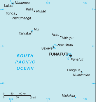
Tuvalu consists of nine small islands scattered over 500,000 sq mi of the western Pacific, just south of the equator. The islands include Niulakita, Nukulaelae, Funafuti, Nukufetau, Vaitupu, Nui, Niutao, Nanumaga (Nanumanga), and Nanumea.
Tuvalu (area: 26 sq km / 10,04 sq mi), where the official language is English, Tuvaluan, lying in Oceania and using the currency; Australian dollar (AUD), set their clock to UTC+12. That means they are 17 hours ahead of Washington DC during Standard Time in Funafuti, the capital. Note to the time difference: N/A.
The climate in Tuvalu; Hot all year round. Heavy annual rainfall. Hurricane season brings many violent storms.
Geography in a nutshell; A series of coral atolls, none more than 15 ft (4.6 m) above sea level. Poor soils restrict vegetation to bush, coconut palms, and breadfruit trees.
Click here for more detailed information about Tuvalu.
Driving directions Tuvalu
The Google maps and Google Satellite maps of Tuvalu above showing the country, located next to N/A. For your further reference, the latitude and longitude coordinates of Tuvalu are 8 00 S, 178 00 E , while the capital, Funafuti found at 8 31 S 179 13 E.
When you are traveling around Tuvalu, Funafuti, or its other cities, use this routing tool, providing up to date route planning service free of charge.
Look no further; get accurate driving directions in Tuvalu, Oceania, by filling the route planner form below.
[xyz-ihs snippet=”routing”]
Since Google acquired and introduced its digitalized maps in 2004, you’re probably familiar with its base functions, like finding an address or driving directions to locations. Still, Google maps also accommodate bicyclists, pedestrians, and also public transportation with special directions and customizable routes.
About Tuvalu and the capital, Funafuti
 |
 |
| The national flag of Tuvalu | Borderline map of Tuvalu |
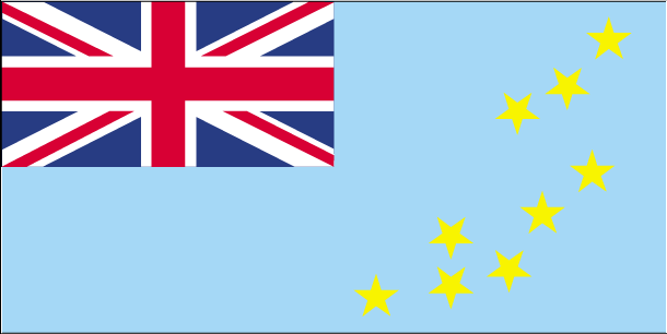
| Flag description: light blue with the flag of the UK in the upper hoist-side quadrant; the outer half of the flag represents a map of the country with nine yellow, five-pointed stars on a blue field symbolizing the nine atolls in the ocean. | Border length: 0 km. |
Did you know about Tuvalu?
- The Ellice Islands separated from the Gilbert and Ellice Islands in 1975, and adopted the name Tuvalu. Independence gained in 1978.
- Low-lying Tuvalu, like the Maldives, is set to disappear with rising sea levels.
- In 1998 Tuvalu sold its “.tv domain name for use on the Internet by television-related Web sites, bringing in millions of dollars.
Facts of Tuvalu (TV)
Name conventional long form: none, conventional short form: Tuvalu, local long form: none, local short form: Tuvalu, former: Ellice Islands. Note: “tuvalu” means “group of eight” referring to the country’s eight traditionally inhabited islands
Codes: ISO; TV, Internet; .tv
Capital city: Funafuti
Language(s): Tuvaluan (official language), English (official language), Samoan, Kiribati (on the island of Nui)
National holiday(s): Independence Day, 1 October (1978)
Motto: Tuvalu mo te Atua (Tuvalu for the Almighty)
Currency: Australian dollar (AUD)
GPS: 8 00 S, 178 00 E, Funafuti; 8 31 S 179 13 E
Location: Oceania, island group consisting of nine coral atolls in the South Pacific Ocean, about half way from Hawaii to Australia
Geography note: one of the smallest and most remote countries on Earth; six of the nine coral atolls – Nanumea, Nui, Vaitupu, Nukufetau, Funafuti, and Nukulaelae – have lagoons open to the ocean; Nanumaya and Niutao have landlocked lagoons; Niulakita does not have a lagoon
Land boundaries: N/A, 0 km
Maritime boundaries: Pacific Ocean
Coastline: 24 km
Area: total: 26 sq km; land: 26 sq km, water: 0 sq km (total 10,04 mi2), 0.1 times the size of Washington, DC.
Roadways: total: 8 km, paved: 8 km (2011)
Waterways: N/A
Local time (capital): UTC+12, 17 hours ahead of Washington DC during Standard Time
Note to the local time: N/A
Population in Tuvalu: 11 287
Population in Funafuti: 5 000 (including the metropolitan areas)
Urbanization: urban population: 59.7% of total population (2015)
Major urban areas population: FUNAFUTI (capital) 6,000 (2014)
Population growth rate: 0.85% (2016 estimate)
Birth rate: 23.8 births / 1,000 population (2016 estimate)
Death rate: 8.6 deaths / 1,000 population (2016 estimate)
Age structure: 0-14 years: 29.32% (male 1,647 / female 1,566) 15-24 years: 19.76% (male 1,132 / female 1,033) 25-54 years: 36.5% (male 1,989 / female 2,011) 55-64 years: 8.66% (male 387 / female 562) 65 years and over: 5.77% (male 255 / female 377) (2016 estimate)
Median age: total: 25.5 years; male: 24.4 years, female: 26.8 years (2016 estimate)
Ethnic groups: Polynesian 96%, Micronesian 4%
Religions: Protestant 98.4% (Church of Tuvalu (Congregationalist) 97%, Seventh-Day Adventist 1.4%), Baha’i 1%, other 0.6%
Government type: Constitutional monarchy
Legal system: mixed legal system of English common law and local customary law
National anthem: Tuvalu mo te Atua (Tuvalu for the Almighty)
Known national hazards: severe tropical storms are usually rare, but in 1997 there were three cyclones; low levels of islands make them sensitive to changes in sea level
Major infectious diseases: N/A
Land use: agricultural land: 60%; arable land 0%; permanent crops 60%; permanent pasture 0%; forest: 33.3%; other: 6.7% (2011 estimate)
Agricultural products: coconuts; fish
Industries: fishing
Export commodities: copra, fish
Main export partners: N/A
Import commodities: food, animals, mineral fuels, machinery, manufactured goods
Main import partners: N/A
Navigate the countries in Oceania faster and easier while driving, use the interactive Google maps for your driving directions. The continuously updated database contains over 220 countries and territories digitally mapped, hundreds of millions of businesses and places around the world positioned on the map.
Get fresh GPS navigation, traffic, and transit information – no matter what part of Tuvalu, Funafuti, any other city and country in Oceania, or the world you’re in.
Do you like this Tuvalu information page? Please don’t forget to share it with others! Thank you.