Earth is the planet we inhabit, a nearly spherical body which rotates every twenty-four hours from west to east around an imaginary line called its axis. The planet Earth, one of nine planets which circle the Sun, completes its revolution in about 365 days and 6 hours. It is the third planet from the Sun, and the only one we know that supports life. The planet Earth is nearly 4,600 million years old and most probably took over 100 million years to form into a ball of rock. The first tiny signs of growth appeared some 3,500 million years ago and life as we know it has evolved over the last 40 to 50 million years.
The Earth regarded as divided into two halves – the northern and the southern hemispheres – by the equator, an imaginary line going right around it midway between the poles. To indicate with precision the position of places on the Earth, additional circles are traced upon the surface so that those of the one set all pass through both poles (meridians), while those of the other are drawn parallel to the equator (parallels of latitude). By reference to them, we can state the latitude and longitude, and thus the exact position, of any place.
Volcanic eruptions produced gases which formed the Earth’s atmosphere – a layer of air approximately 1,000 kilometers or 620 miles thick which contains mainly gases (oxygen, nitrogen and carbon dioxide) and water vapor. This layer shields the Earth from the harmful ultraviolet rays emanating from the Sun and protects it from extremes of temperature. The Earth’s seas and oceans formed when the same eruptions also produced huge volumes of water vapor which condensed to fill the hollows in the Earth’s crust.
The surface of the Earth covers 510,069,120 square kilometers or 196,938,800 square miles of which about 30 percent is dry land, the remaining 70 percent being water. The land arranged into masses of irregular shape and size. The chief masses are called continents while detached masses of smaller size are islands. The surface of the land consists of mountains, valleys, plains, plateaux, and deserts. The water area of the Earth is divided into oceans, seas, bays, gulfs and so on, while rivers and lakes regarded as features of the land surface. The Earth’s seas and oceans have an average depth of 3.5 kilometers or 2.2 miles. The great phenomena of the oceans are their currents and tides.
The Earth’s daily motion about its axis takes place in 23 hours, 56 minutes and 4 seconds of meantime. This revolution brings about the alternation of day and night. As the axis on which the Earth rotates inclined towards the plane of its path about the Sun at an angle of 66.5° and the angle between the plane of the ecliptic and the plane of the Earth’s equator is therefore 23.5°, the Sun ascends, as seen from our northern latitudes, from 21st March to 21st June (the summer solstice) to about 23.5° above the celestial equator and descends again towards the equator from 21st June to 23rd September. It then sinks till 22nd December (the winter solstice), when it is about 23.5° below the equator and returns to the equator by 21st March. This arrangement is the cause of the seasons and the unequal measure of day and night during them.
For all places removed from the equator, day and night are equal only twice in the year (at the equinoxes). At the summer solstice in the northern hemisphere, the North Pole of the Earth turned towards the Sun and the South Pole away from it.
For places within 23.5° of the North Pole there is a period of longer or shorter duration during which the Sun is continually above the horizon throughout the 24 hours of each day. Round the South Pole there is an equal extent of surface within which the Sun for similar periods is below the horizon. The reverse occurs at the winter solstice. The circles bounding these regions are called respectively the Arctic and the Antarctic Circles and the regions themselves, the polar or frigid zones. Throughout a region extending to 23.5° on each side of the equator the Sun is directly overhead at any place twice in the year. The circles which bound this region are called the tropics – the Tropic of Cancer in the northern hemisphere and the Tropic of Capricorn in the southern hemisphere, while the region between is the torrid zone. The regions between the tropics and the polar circles are the north and south temperate zones respectively.
The term ‘earth sciences’ has entered our vocabulary, covering a synthesis of the traditional disciplines of geology, geophysics, geochemistry, oceanography, and meteorology. This new focus reflects worldwide concern as to how the Earth’s resources can be best sustained.
In comparison to the age of the Earth, man’s relatively short existence has caused alarming levels of pollution, and the environment is under increasing stress. Ozone forms a key layer in the upper atmosphere, and there is concern over damage to it, caused by chlorofluorocarbons, chemicals used by man that release chlorine into the upper atmosphere, destroying the ozone. The World sustains more than 5,000 million people. The population has doubled since the early 1950s. Many experts believe that the population could double again within the next half-century. We must learn to sustain this growth and face the growing ecological crisis.
Earth facts and figures
Surface area: 510,069,120 square kilometres or 196,933,300 square miles
Land area: 150,000,000 square kilometres or 57,500,000 square miles
Seas and oceans area: 361,000,000 square kilometres or 139,400,000 square miles (70.9 per cent of the Earth’s surface)
Mass: 6,000 billion, billion tonnes
Diameter: 12,756 kilometers or 7,926 miles at the equator and 12,714 kilometers or 7,900 miles at the poles
Circumference: 40,075 kilometers or 24,901 miles at the equator
Distance from the Sun: 149, 500,000 kilometers or 93,000,000 miles
Rotation period: 23 hours 56 minutes, 4.1 seconds
Year: 365 days 5 hours 56 minutes 4.1 seconds
Age: 4,600 million years
The Earth’s structure
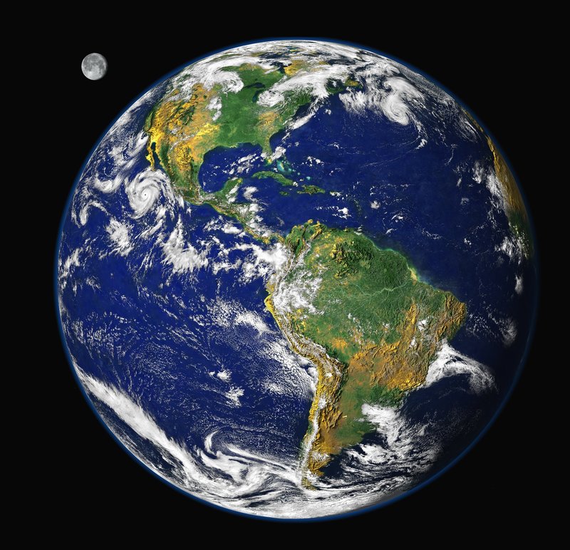
Man has been able to study the surface of his planet for as long as the Earth has inhabited. It is strange to think that nobody had predicted accurately what it would look like from space. Now the Earth can be seen and photographed from space as a beautiful blue and white planet.
Many factors make the Earth unique in the solar system. It is the only planet with substantial amounts of liquid water (oceans cover almost three-quarters of the Earth’s surface). This vast quantity of water is a powerful force of erosion, the wearing away of the Earth’s surface. Glaciers, wind and rain erode mountains. Rivers etch channels through rocks and lowland plains, carrying sediment away from one place and depositing it in another.
Unlike the older rocky planets, the Earth has layers containing tremendous forces that are very active, namely the crust, mantle and two inner cores, one of liquid iron and one of, possibly, solid iron. Magnetism generated by electric currents flowing through the liquid iron core, which is why a compass needle lines up with the Earth’s magnetism and points to the north.
Compared with most of the other rocky worlds in the solar system, Earth is a hive of geological activity. Mountains are constantly being thrust up; earthquakes make the globe tremble and volcanoes cough out liquid rock. This all happens because the crust of the Earth consists of several large plates that will not keep still. According to theory, heat (partly from the decay of radioactive rocks) flowing from underneath the plates causes this motion. In certain places, the plates push into each other and cause tremendous buckling. This crumpling of two continental plates has caused the formation of the Alps and Himalayas. Along the west coast of North and South America the continental plates are being forced against the oceanic plates, and this has formed a great range of coastal mountains from Alaska to southern Chile. Another effect of these rock movements is to generate friction. This may melt the rock below the surface, and this molten material works its way upwards through cracks and erupts like a volcano.