Singapore Google maps and Driving Directions
Get free driving directions, Google maps, traffic information for Singapore, and Singapore (GPS: 1 17 N 103 51 E), the capital city of the country located in (the) Southeastern Asia, islands between Malaysia and Indonesia.
Find any address in Singapore on the Google map of Singapore (SG) with ease or calculate your up to date itinerary to and from Singapore or its neighboring counties like Malaysia.
Sightseeing and exploring in Asia starts here, thanks to Google because its Earth Engine combines a multi-petabyte catalog of updated satellite imagery and geospatial datasets with planetary-scale analysis capabilities. Wonder the world, use the satellite map function of the Google maps to explore or see differences on the Earth’s surface, inland, or the surrounding areas of Singapore.
Google Maps Singapore
Linked to the southernmost tip of the Malay peninsula by a causeway, Singapore was established as a trading settlement in 1819. It is one of Asias most important commercial centers.
Singapore is lowlying, gently undulating central plateau.
The map above fully covers Singapore with its road routes from cities to towns, road intersections in any region, provinces, prefectures, also with free driving directions in Singapore or to the neighboring towns and countries. To look at the detailed map about a particular quarter in Singapore, please click on the area and zoom to the place you are interested in the Google maps of Singapore (SG).
Be creative, use the extras of this Google map; This is a detailed, clear, zoomable, large road map of Singapore with its administrative divisions; none.
The interactive map above is also may be used as the satellite map of Singapore, or as a reverse search map for finding an address from its GPS coordinates.
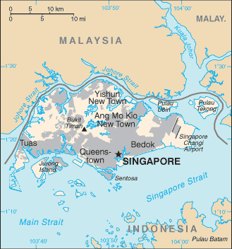
The Republic of Singapore consists of the main island of Singapore, off the southern tip of the Malay Peninsula between the South China Sea and the Indian Ocean, and 58 nearby islands.
Singapore (area: 710 sq km / 274,13 sq mi), where the official language is English, Malay, Standard Chinese, Tamil, lying in Asia and using the currency; Singapore dollar (SGD), set their clock to UTC+8. That means they are 13 hours ahead of Washington DC during Standard Time in Singapore, the capital. Note to the time difference: N/A.
The climate in Singapore; Equatorial. Hot and humid, with heavy rainfall all year round.
Geography in a nutshell; Little remains of the original vegetation on Singapore Island. The other 54 much smaller islands are little more than swampy jungle.
Click here for more detailed information about Singapore.
Driving directions Singapore
The Google maps and Google Satellite maps of Singapore above showing the country, located next to Malaysia. For your further reference, the latitude and longitude coordinates of Singapore are 1 22 N, 103 48 E , while the capital, Singapore found at 1 17 N 103 51 E.
When you are traveling around Singapore, Singapore, or its other cities, use this routing tool, providing up to date route planning service free of charge.
Look no further; get accurate driving directions in Singapore, Southeast Asia, by filling the route planner form below.
Since Google acquired and introduced its digitalized maps in 2004, you’re probably familiar with its base functions, like finding an address or driving directions to locations. Still, Google maps also accommodate bicyclists, pedestrians, and also public transportation with special directions and customizable routes.
About Singapore and the capital, Singapore
 |
 |
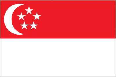
| The national flag of Singapore | Borderline map of Singapore |
| Flag description: two equal horizontal bands of red (top) and white; near the hoist side of the red band, there is a vertical, white crescent (closed portion is toward the hoist side) partially enclosing five white five-pointed stars arranged in a circle; red denotes brotherhood and equality; white signifies purity and virtue; the waxing crescent moon symbolizes a young nation on the ascendancy; the five stars represent the nation’s ideals of democracy, peace, progress, justice, and equality. | Border length: 0 km. |
Did you know about Singapore?
- Granted self-government by Britain in 1959, Singapore became part of the Federation of Malaysia in 1963, and fully independent in 1965.
- Chewing gum was banned outright from 1992 to 2004.
- The island nation of Singapore is the worlds busiest port, handling ships from China, Japan, the Middle East, and Europe.
Facts of Singapore (SG)
Name conventional long form: Republic of Singapore, conventional short form: Singapore, local long form: Republic of Singapore, local short form: Singapore, etymology: name derives from the Sanskrit words “singa” (lion) and “pura” (city) to describe the city-state’s leonine symbol
Codes: ISO; SG, Internet; .sg
Capital city: Singapore
Language(s): Mandarin (official language) 36.3%, English (official language) 29.8%, Malay (official language) 11.9%, Hokkien 8.1%, Cantonese 4.1%, Tamil (official language) 3.2%, Teochew 3.2%, other Indian languages 1.2%, other Chinese dialects 1.1%, other 1.1% (2010 estimate)
National holiday(s): National Day, 9 August (1965)
Motto: Majulah Singapura (Onward, Singapore)
Currency: Singapore dollar (SGD)
GPS: 1 22 N, 103 48 E, Singapore; 1 17 N 103 51 E
Location: Southeastern Asia, islands between Malaysia and Indonesia
Geography note: focal point for Southeast Asian sea routes
Land boundaries: N/A, 0 km
Maritime boundaries: N/A
Coastline: 193 km
Area: total: 697 sq km; land: 687 sq km, water: 10 sq km (total 274,13 mi2), slightly more than 3.5 times the size of Washington, DC.
Roadways: total: 3,425 km, paved: 3,425 km (includes 161 km of expressways) (2012)
Waterways: N/A
Local time (capital): UTC+8, 13 hours ahead of Washington DC during Standard Time
Note to the local time: N/A
Population in Singapore: 5 791 901
Population in Singapore: 5 469 700 (including the metropolitan areas)
Urbanization: urban population: 100% of total population (2015)
Major urban areas population: SINGAPORE (capital) 5.619 million (2015)
Population growth rate: 1.86% (2016 estimate)
Birth rate: 8.4 births / 1,000 population (2016 estimate)
Death rate: 3.5 deaths / 1,000 population (2016 estimate)
Age structure: 0-14 years: 12.94% (male 382,479 / female 365,595) 15-24 years: 17.02% (male 484,355 / female 499,940) 25-54 years: 50.45% (male 1,420,833 / female 1,496,125) 55-64 years: 10.34% (male 299,446 / female 298,562) 65 years and over: 9.24% (male 243,418 / female 290,975) (2016 estimate)
Median age: total: 34.3 years; male: 34.2 years, female: 34.4 years (2016 estimate)
Ethnic groups: Chinese 74.2%, Malay 13.3%, Indian 9.2%, other 3.3% (2013 estimate)
Religions: Buddhist 33.9%, Muslim 14.3%, Taoist 11.3%, Catholic 7.1%, Hindu 5.2%, other Christian 11%, other 0.7%, none 16.4% (2010 estimate)
Government type: Unitary parliamentary republic
Legal system: English common law
National anthem: Majulah Singapura (Onward, Singapore)
Known national hazards: N/A
Major infectious diseases: note: active local transmission of Zika virus by Aedes species mosquitoes has been identified in this country (as of August 2016); it poses an important risk (a large number of cases possible) among US citizens if bitten by an infective mosquito; other less common ways to get Zika are through sex, via blood transfusion, or during pregnancy, in which the pregnant woman passes Zika virus to her fetus (2016)
Land use: agricultural land: 1%; arable land 0.9%; permanent crops 0.1%; permanent pasture 0%; forest: 3.3%; other: 95.7% (2011 estimate)
Agricultural products: orchids, vegetables; poultry, eggs; fish, ornamental fish
Industries: electronics, chemicals, financial services, oil drilling equipment, petroleum refining, rubber processing and rubber products, processed food and beverages, ship repair, offshore platform construction, life sciences, entrepot trade
Export commodities: machinery and equipment (including electronics and telecommunications), pharmaceuticals and other chemicals, refined petroleum products, foodstuffs and beverages
Main export partners: China 13.7%, Hong Kong 11.5%, Malaysia 10.8%, Indonesia 8.2%, US 6.9%, Japan 4.4%, South Korea 4.1% (2015)
Import commodities: machinery and equipment, mineral fuels, chemicals, foodstuffs, consumer goods
Main import partners: China 14.2%, US 11.2%, Malaysia 11.2%, Japan 6.3%, South Korea 6.1%, Indonesia 4.8% (2015)
Navigate the countries in Southeast Asia faster and easier while driving, use the interactive Google maps for your driving directions. The continuously updated database contains over 220 countries and territories digitally mapped, hundreds of millions of businesses and places around the world positioned on the map.
Get fresh GPS navigation, traffic, and transit information – no matter what part of Singapore, Singapore, any other city and country in Asia, or the world you’re in.
Do you like this Singapore information page? Please don’t forget to share it with others! Thank you.