Nepal Google maps and Driving Directions
Get free driving directions, Google maps, traffic information for Nepal, and Kathmandu (GPS: 27 43 N 85 19 E), the capital city of the country located in (the) Southern Asia, between China and India.
Find any address in Kathmandu on the Google map of Nepal (NP) with ease or calculate your up to date itinerary to and from Nepal or its neighboring counties like China, India.
Sightseeing and exploring in Asia starts here, thanks to Google because its Earth Engine combines a multi-petabyte catalog of updated satellite imagery and geospatial datasets with planetary-scale analysis capabilities. Wonder the world, use the satellite map function of the Google maps to explore or see differences on the Earth’s surface, inland, or the surrounding areas of Nepal.
Google Maps Nepal
Nepal, lying between India and China on the southern shoulder of the Himalayas, is one of the worlds poorest countries. Its agricultural economy is heavily dependent on the monsoon.
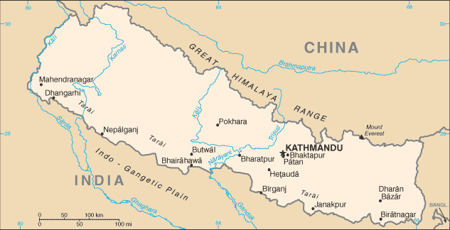
Nepal is Tarai or flat river plain of the Ganges in south; central hill region with rugged Himalayas in north.
The map above fully covers Nepal with its road routes from cities to towns, road intersections in any region, provinces, prefectures, also with free driving directions in Kathmandu or to the neighboring towns and countries. To look at the detailed map about a particular quarter in Kathmandu, please click on the area and zoom to the place you are interested in the Google maps of Nepal (NP).
Be creative, use the extras of this Google map; This is a detailed, clear, zoomable, large road map of Nepal with its administrative divisions; 14 zones (anchal, singular and plural); Bagmati, Bheri, Dhawalagiri, Gandaki, Janakpur, Karnali, Kosi, Lumbini, Mahakali, Mechi, Narayani, Rapti, Sagarmatha, Seti.
The interactive map above is also may be used as the satellite map of Nepal, or as a reverse search map for finding an address from its GPS coordinates.
A landlocked country the size of Arkansas, lying between India and the Tibetan Autonomous Region of China, Nepal contains Mount Everest (29,035 ft 8,850 m), the tallest mountain in the world. Along its southern border, Nepal has a strip of level land that is partly forested, partly cultivated. North of that is the slope of the main section of the Himalayan range, including Everest and many other peaks higher than 8,000 m.
Nepal (area: 147 181 sq km / 56 826,88 sq mi), where the official language is Nepali, lying in Asia and using the currency; Nepalese rupee (NPR), since 1932, set their clock to UTC+5.75. That means they are 10.75 hours ahead of Washington DC during Standard Time in Kathmandu, the capital. Note to the time difference: N/A.
The climate in Nepal; Warm monsoon season from July to October. The rest of the year is dry, sunny, and mild. Winter temperatures in the Himalayas average 14°F (10°C).
Geography in a nutshell; Mainly mountainous. The area includes some of the highest mountains in the world, including Mount Everest. Flat, fertile river plains form the south.
Click here for more detailed information about Nepal.
Driving directions Nepal
The Google maps and Google Satellite maps of Nepal above showing the country, located next to China, India. For your further reference, the latitude and longitude coordinates of Nepal are 28 00 N, 84 00 E , while the capital, Kathmandu found at 27 43 N 85 19 E.
When you are traveling around Nepal, Kathmandu, or its other cities, use this routing tool, providing up to date route planning service free of charge.
Look no further; get accurate driving directions in Nepal, Asia, by filling the route planner form below.
Since Google acquired and introduced its digitalized maps in 2004, you’re probably familiar with its base functions, like finding an address or driving directions to locations. Still, Google maps also accommodate bicyclists, pedestrians, and also public transportation with special directions and customizable routes.
About Nepal and the capital, Kathmandu
 |
 |
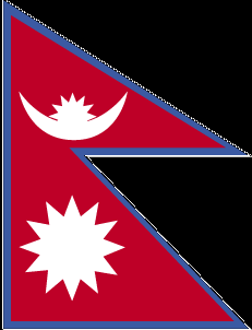
| The national flag of Nepal | Borderline map of Nepal |
| Flag description: red with a blue border around the unique shape of two overlapping right triangles; the smaller, upper triangle bears a white stylized moon and the larger, lower triangle displays a white 12-pointed sun; the color red represents the rhododendron (Nepal’s national flower) and is a sign of victory and bravery, the blue border signifies peace and harmony; the two right triangles are a combination of two single pennons (pennants) that originally symbolized the Himalaya Mountains while their charges represented the families of the king (upper) and the prime minister, but today they are understood to denote Hinduism and Buddhism, the country’s two main religions; the moon represents the serenity of the Nepalese people and the shade and cool weather in the Himalayas, while the sun depicts the heat and higher temperatures of the lower parts of Nepal; the moon and the sun are also said to express the hope that the nation will endure as long as these heavenly bodies. Note: Nepal is the only country in the world whose flag is not rectangular or square. | Border length: total: 3,159 km. Border countries (total: 2): China 1,389 km, India 1,770 km. |
Did you know about Nepal?
- From 1960 Nepal was ruled by an absolute monarchy. This regime ended in 1991 when the first multiparty elections were held.
- Southern Nepal was the birthplace of Buddha (Prince Siddhartha Gautama) in 563 BCE.
- Native Nepalese known as Sherpas serve as guides for the many mountaineers who come to climb Everest and other Himalayan mountains.
Facts of Nepal (NP)
Name conventional long form: Federal Democratic Republic of Nepal, conventional short form: Nepal, local long form: Sanghiya Loktantrik Ganatantra Nepal, local short form: Nepal, etymology: the Newar people of the Kathmandu Valley and surrounding areas apparently gave their name to the country; the terms “Nepal,” “Newar,” “Nepar,” and “Newal” are phonetically different forms of the same word
Codes: ISO; NP, Internet; .np
Capital city: Kathmandu
Language(s): Nepali (official language) 44.6%, Maithali 11.7%, Bhojpuri 6%, Tharu 5.8%, Tamang 5.1%, Newar 3.2%, Magar 3%, Bajjika 3%, Urdu 2.6%, Avadhi 1.9%, Limbu 1.3%, Gurung 1.2%, other 10.4%, unspecified 0.2%. Note: 123 languages reported as mother tongue in 2011 national census; many in government and business also speak English (2011 estimate)
National holiday(s): Republic Day, 28 May (2008), the abdication of Gyanendra SHAH, last Nepalese monarch, and the establishment of a federal republic
Motto: Mother and Motherland are Greater than Heaven
Currency: Nepalese rupee (NPR), since 1932
GPS: 28 00 N, 84 00 E, Kathmandu; 27 43 N 85 19 E
Location: Southern Asia, between China and India
Geography note: landlocked country; strategic location between China and India; contains eight of world’s 10 highest peaks, including Mount Everest and Kanchenjunga – the world’s tallest and third tallest mountains – on the borders with China and India respectively
Land boundaries: China 1,389 km, India 1,770 km, total: 3,159 km
Maritime boundaries: N/A
Coastline: 0 km (landlocked country)
Area: total: 147,181 sq km; land: 143,351 sq km, water: 3,830 sq km (total 56 826,88 mi2), slightly larger than Arkansas.
Roadways: total: 10,844 km, paved: 4,952 km, unpaved: 5,892 km (2010)
Waterways: N/A
Local time (capital): UTC+5.75, 10.75 hours ahead of Washington DC during Standard Time
Note to the local time: N/A
Population in Nepal: 29 624 035
Population in Kathmandu: 1 203 100 (including the metropolitan areas)
Urbanization: urban population: 18.6% of total population (2015)
Major urban areas population: KATHMANDU (capital) 1.183 million (2015)
Population growth rate: 1.24% (2016 estimate)
Birth rate: 19.9 births / 1,000 population (2016 estimate)
Death rate: 5.7 deaths / 1,000 population (2016 estimate)
Age structure: 0-14 years: 30.93% (male 4,646,048 / female 4,333,105) 15-24 years: 21.86% (male 3,176,158 / female 3,169,721) 25-54 years: 35.99% (male 4,707,264 / female 5,740,985) 55-64 years: 6.22% (male 877,288 / female 927,202) 65 years and over: 5.02% (male 723,523 / female 732,620) (2016 estimate)
Median age: total: 23.6 years; male: 22.4 years, female: 24.8 years (2016 estimate)
Ethnic groups: Chhettri 16.6%, Brahman-Hill 12.2%, Magar 7.1%, Tharu 6.6%, Tamang 5.8%, Newar 5%, Kami 4.8%, Muslim 4.4%, Yadav 4%, Rai 2.3%, Gurung 2%, Damai/Dholii 1.8%, Thakuri 1.6%, Limbu 1.5%, Sarki 1.4%, Teli 1.4%, Chamar/Harijan/Ram 1.3%, Koiri/Kushwaha 1.2%, other 19%note: 125 caste/ethnic groups were reported in the 2011 national census (2011 estimate)
Religions: Hindu 81.3%, Buddhist 9%, Muslim 4.4%, Kirant 3.1%, Christian 1.4%, other 0.5%, unspecifed 0.2% (2011 estimate)
Government type: Federal parliamentary republic
Legal system: English common law and Hindu legal concepts
National anthem: Sayaun Thunga Phool Ka (Made of Hundreds of Flowers)
Known national hazards: severe thunderstorms; flooding; landslides; drought and famine depending on the timing, intensity, and duration of the summer monsoons
Major infectious diseases: The degree of risk(s): high food or waterborne diseases: bacterial diarrhea, hepatitis A and E, and typhoid fever vectorborne disease: Japanese encephalitis, malaria, and dengue fever (2016)
Land use: agricultural land: 28.8%; arable land 15.1%; permanent crops 1.2%; permanent pasture 12.5%; forest: 25.4%; other: 45.8% (2011 estimate)
Agricultural products: pulses, rice, corn, wheat, sugarcane, jute, root crops; milk, water buffalo meat
Industries: tourism, carpets, textiles; small rice, jute, sugar, and oilseed mills; cigarettes, cement and brick production
Export commodities: clothing, pulses, carpets, textiles, juice, jute goods
Main export partners: India 61.3%, US 9.4% (2015)
Import commodities: petroleum products, machinery and equipment, gold, electrical goods, medicine
Main import partners: India 61.5%, China 15.4% (2015)
Navigate the countries in Asia faster and easier while driving, use the interactive Google maps for your driving directions. The continuously updated database contains over 220 countries and territories digitally mapped, hundreds of millions of businesses and places around the world positioned on the map.
Get fresh GPS navigation, traffic, and transit information – no matter what part of Nepal, Kathmandu, any other city and country in Asia, or the world you’re in.
Do you like this Nepal information page? Please don’t forget to share it with others! Thank you.