Samoa Google maps and Driving Directions
Get free driving directions, Google maps, traffic information for Samoa, and Apia (GPS: 13 49 S 171 46 W), the capital city of the country located in (the) Oceania, group of islands in the South Pacific Ocean, about halfway between Hawaii and New Zealand.
Find any address in Apia on the Google map of Samoa (WS) with ease or calculate your up to date itinerary to and from Samoa or its neighboring counties like N/A.
Sightseeing and exploring in Oceania starts here, thanks to Google because its Earth Engine combines a multi-petabyte catalog of updated satellite imagery and geospatial datasets with planetary-scale analysis capabilities. Wonder the world, use the satellite map function of the Google maps to explore or see differences on the Earth’s surface, inland, or the surrounding areas of Samoa.
Google Maps Samoa
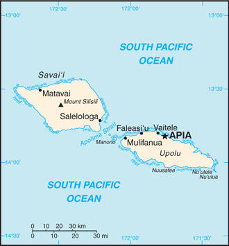
The Pacific islands of Samoa gained independence from New Zealand in 1962. Four of the nine volcanic islands are inhabited Apolima, Manono, Savaii, and Upolu.
Samoa is two main islands (Savaii, Upolu) and several smaller islands and uninhabited islets; narrow coastal plain with volcanic, rugged mountains in interior.
The map above fully covers Samoa with its road routes from cities to towns, road intersections in any region, provinces, prefectures, also with free driving directions in Apia or to the neighboring towns and countries. To look at the detailed map about a particular quarter in Apia, please click on the area and zoom to the place you are interested in the Google maps of Samoa (WS).
Be creative, use the extras of this Google map; This is a detailed, clear, zoomable, large road map of Samoa with its administrative divisions; 11 districts; A’ana, Aiga-i-le-Tai, Atua, Fa’asaleleaga, Gaga’emauga, Gagaifomauga, Palauli, Satupa’itea, Tuamasaga, Va’a-o-Fonoti, Vaisigano.
The interactive map above is also may be used as the satellite map of Samoa, or as a reverse search map for finding an address from its GPS coordinates.
Samoa, formerly Western Samoa, is in the South Pacific Ocean about 2,200 mi (3,540 km) south of Hawaii. The larger islands in the Samoan chain, Upolu and Savai’i, are mountainous and of volcanic origin. There is little level land except in the coastal areas, where most cultivation takes place.
Samoa (area: 2 842 sq km / 1 097,30 sq mi), where the official language is English, Samoan, lying in Oceania and using the currency; Samoan tala (WST), since 1967, set their clock to UTC+13. That means they are 18 hours ahead of Washington DC during Standard Time in Apia, the capital. Note to the time difference: +1hr begins last Sunday in September; ends first Sunday in April.
The climate in Samoa; Tropical, with high humidity. Cooler in MayNovember. Cyclone season is DecemberMarch.
Geography in a nutshell; Comprises two large islands and seven smaller ones. The two largest islands have rainforested, mountainous interiors surrounded by coastal lowlands and coral reefs.
Click here for more detailed information about Samoa.
Driving directions Samoa
The Google maps and Google Satellite maps of Samoa above showing the country, located next to N/A. For your further reference, the latitude and longitude coordinates of Samoa are 13 35 S, 172 20 W , while the capital, Apia found at 13 49 S 171 46 W.
When you are traveling around Samoa, Apia, or its other cities, use this routing tool, providing up to date route planning service free of charge.
Look no further; get accurate driving directions in Samoa, Oceania, by filling the route planner form below.
Since Google acquired and introduced its digitalized maps in 2004, you’re probably familiar with its base functions, like finding an address or driving directions to locations. Still, Google maps also accommodate bicyclists, pedestrians, and also public transportation with special directions and customizable routes.
About Samoa and the capital, Apia
 |
 |
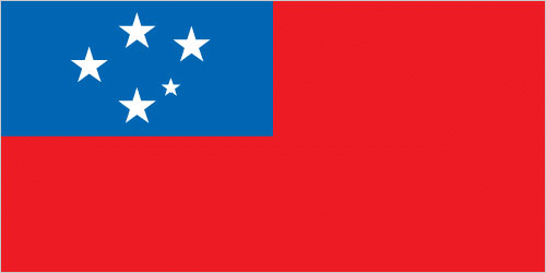
| The national flag of Samoa | Borderline map of Samoa |
| Flag description: red with a blue rectangle in the upper hoist-side quadrant bearing five white five-pointed stars representing the Southern Cross constellation; red stands for courage, blue represents freedom, and white signifies purity. | Border length: 0 km. |
Did you know about Samoa?
- Under the administration of Germany, the USA and later New Zealand, Samoa became the first independent Polynesian nation in 1962.
- Samoa was named for the sacred (sa) chickens (moa) of Lu, son of Tagaloa, the god of creatio.
- Forestry and agriculture provide the main exports for this island nation, while tourism boosts the local income.
Facts of Samoa (WS)
Name conventional long form: Independent State of Samoa, conventional short form: Samoa, local long form: Malo Sa’oloto Tuto’atasi o Samoa, local short form: Samoa, former: Western Samoa. Note: the name “Samoa” is composed of two parts, “sa” meaning sacred and “moa” meaning center, so the name can mean Holy Center; alternatively, it can mean “place of the sacred moa bird” of Polynesian mythology
Codes: ISO; WS, Internet; .ws
Capital city: Apia
Language(s): Samoan (Polynesian) (official language), English
National holiday(s): Independence Day Celebration, 1 June (1962)
Motto: Faavae i le Atua Samoa (Samoa is founded on God)
Currency: Samoan tala (WST), since 1967
GPS: 13 35 S, 172 20 W, Apia; 13 49 S 171 46 W
Location: Oceania, group of islands in the South Pacific Ocean, about halfway between Hawaii and New Zealand
Geography note: occupies an almost central position within Polynesia
Land boundaries: N/A, 0 km
Maritime boundaries: Pacific Ocean
Coastline: 403 km
Area: total: 2,831 sq km; land: 2,821 sq km, water: 10 sq km (total 1 097,30 mi2), slightly smaller than Rhode Island.
Roadways: total: 2,337 km, paved: 332 km, unpaved: 2,005 km (2001)
Waterways: N/A
Local time (capital): UTC+13, 18 hours ahead of Washington DC during Standard Time
Note to the local time: +1hr begins last Sunday in September; ends first Sunday in April
Population in Samoa: 55 679
Population in Apia: 37 000 (including the metropolitan areas)
Urbanization: urban population: 19.1% of total population (2015)
Major urban areas population: APIA (capital) 37,000 (2014)
Population growth rate: 0.59% (2016 estimate)
Birth rate: 20.6 births / 1,000 population (2016 estimate)
Death rate: 5.3 deaths / 1,000 population (2016 estimate)
Age structure: 0-14 years: 32.04% (male 32,893 / female 30,847) 15-24 years: 19.89% (male 20,302 / female 19,258) 25-54 years: 35.95% (male 36,889 / female 34,631) 55-64 years: 6.52% (male 6,602 / female 6,364) 65 years and over: 5.6% (male 4,843 / female 6,297) (2016 estimate)
Median age: total: 23.9 years; male: 23.7 years, female: 24.2 years (2016 estimate)
Ethnic groups: Samoan 92.6%, Euronesians (persons of European and Polynesian blood) 7%, Europeans 0.4% (2001 census)
Religions: Protestant 57.4% (Congregationalist 31.8%, Methodist 13.7%, Assembly of God 8%, Seventh-Day Adventist 3.9%), Roman Catholic 19.4%, Mormon 15.2%, Worship Centre 1.7%, other Christian 5.5%, other 0.7%, none 0.1%, unspecified 0.1% (2011 estimate)
Government type: Unitary parliamentary democracy
Legal system: mixed legal system of English common law and customary law; judicial review of legislative acts with respect to fundamental rights of the citizen
National anthem: The Banner of Freedom
Known national hazards: occasional typhoons; active volcanismvolcanism: Savai’I Island (elev. 1,858 m), which last erupted in 1911, is historically active
Major infectious diseases: note: active local transmission of Zika virus by Aedes species mosquitoes has been identified in this country (as of August 2016); it poses an important risk (a large number of cases possible) among US citizens if bitten by an infective mosquito; other less common ways to get Zika are through sex, via blood transfusion, or during pregnancy, in which the pregnant woman passes Zika virus to her fetus (2016)
Land use: agricultural land: 12.4%; arable land 2.8%; permanent crops 7.8%; permanent pasture 1.8%; forest: 60.4%; other: 27.2% (2011 estimate)
Agricultural products: coconuts, nonu, bananas, taro, yams, coffee, cocoa
Industries: food processing, building materials, auto parts
Export commodities: fish, coconut oil and cream, nonu, copra, taro, automotive parts, garments, beer
Main export partners: American Samoa 57.1%, Australia 17.2% (2015)
Import commodities: machinery and equipment, industrial supplies, foodstuffs
Main import partners: Fiji 22.6%, NZ 18.8%, China 15.8%, South Korea 7.9%, Australia 6%, US 5.6%, Singapore 5.2% (2015)
Navigate the countries in Oceania faster and easier while driving, use the interactive Google maps for your driving directions. The continuously updated database contains over 220 countries and territories digitally mapped, hundreds of millions of businesses and places around the world positioned on the map.
Get fresh GPS navigation, traffic, and transit information – no matter what part of Samoa, Apia, any other city and country in Oceania, or the world you’re in.
Do you like this Samoa information page? Please don’t forget to share it with others! Thank you.