Mongolia Google maps and Driving Directions
Get free driving directions, Google maps, traffic information for Mongolia, and Ulaanbaatar (GPS: 47 55 N 106 55 E), the capital city of the country located in (the) Northern Asia, between China and Russia.
Find any address in Ulaanbaatar on the Google map of Mongolia (MN) with ease or calculate your up to date itinerary to and from Mongolia or its neighboring counties like China, Russia.
Sightseeing and exploring in Asia starts here, thanks to Google because its Earth Engine combines a multi-petabyte catalog of updated satellite imagery and geospatial datasets with planetary-scale analysis capabilities. Wonder the world, use the satellite map function of the Google maps to explore or see differences on the Earth’s surface, inland, or the surrounding areas of Mongolia.
Google Maps Mongolia
Landlocked between Russia and China, Mongolia is a huge, isolated, and sparsely populated nation. Over two-thirds of the country is part of the Gobi Desert.
Mongolia is vast semidesert and desert plains, grassy steppe, mountains in west and southwest; Gobi Desert in south-central.
The map above fully covers Mongolia with its road routes from cities to towns, road intersections in any region, provinces, prefectures, also with free driving directions in Ulaanbaatar or to the neighboring towns and countries. To look at the detailed map about a particular quarter in Ulaanbaatar, please click on the area and zoom to the place you are interested in the Google maps of Mongolia (MN).
Be creative, use the extras of this Google map; This is a detailed, clear, zoomable, large road map of Mongolia with its administrative divisions; 21 provinces (aymguud, singular – aymag) and 1 municipality* (singular – hot); Arhangay, Bayanhongor, Bayan-Olgiy, Bulgan, Darhan-Uul, Dornod, Dornogovi, Dundgovi, Dzavhan (Zavkhan), Govi-Altay, Govisumber, Hentiy, Hovd, Hovsgol, Omnogovi, Orhon, Ovorhangay, Selenge, Suhbaatar, Tov, Ulaanbaatar*, Uvs.
The interactive map above is also may be used as the satellite map of Mongolia, or as a reverse search map for finding an address from its GPS coordinates.
Mongolia lies in central Asia between Siberia on the north and China on the south. It is slightly larger than Alaska. The productive regions of Mongolia – a tableland ranging from 3,000 to 5,000 ft (914 to 1,524 m) in elevation – are in the north, which is well drained by numerous rivers, including the Hovd, Onon, Selenga, and Tula. Much of the Gobi Desert falls within Mongolia.
Mongolia (area: 1 564 100 sq km / 603 902,14 sq mi), where the official language is Mongolian, lying in Asia and using the currency; Mongolian tögrög (MNT), since 1993, set their clock to UTC+8. That means they are 13 hours ahead of Washington DC during Standard Time in Ulaanbaatar, the capital. Note to the time difference: Daylight saving time: +1hr begins last Saturday in March; ends last Saturday in September. Note: Mongolia has two time zones – Ulaanbaatar Time (8 hours in advance of UTC).
The climate in Mongolia; Continental. Mild summers and long, dry, very cold winters, with heavy snowfall. Temperatures can drop as low as 22°F (30°C).
Geography in a nutshell; A mountainous steppe plateau in the north, with lakes in the north and west. The desert region of the Gobi dominates the south.
Click here for more detailed information about Mongolia.
Driving directions Mongolia
The Google maps and Google Satellite maps of Mongolia above showing the country, located next to China, Russia. For your further reference, the latitude and longitude coordinates of Mongolia are 46 00 N, 105 00 E , while the capital, Ulaanbaatar found at 47 55 N 106 55 E.
When you are traveling around Mongolia, Ulaanbaatar, or its other cities, use this routing tool, providing up to date route planning service free of charge.
Look no further; get accurate driving directions in Mongolia, Asia, by filling the route planner form below.
Since Google acquired and introduced its digitalized maps in 2004, you’re probably familiar with its base functions, like finding an address or driving directions to locations. Still, Google maps also accommodate bicyclists, pedestrians, and also public transportation with special directions and customizable routes.
About Mongolia and the capital, Ulaanbaatar
 |
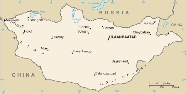 |
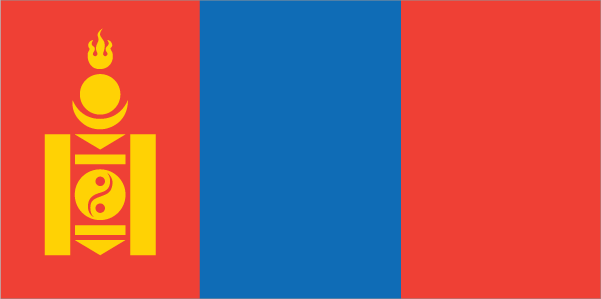
| The national flag of Mongolia | Borderline map of Mongolia |
| Flag description: three, equal vertical bands of red (hoist side), blue, and red; centered on the hoist-side red band in yellow is the national emblem (“soyombo” – a columnar arrangement of abstract and geometric representation for fire, sun, moon, earth, water, and the yin-yang symbol); blue represents the sky, red symbolizes progress and prosperity. | Border length: total: 8,082 km. Border countries (total: 2): China 4,630 km, Russia 3,452 km. |
Did you know about Mongolia?
- Mongolia is a remote state that has been under communist rule since 1924. The former Communist Party was democratically re-elected in 1997.
- Horseracing, wrestling, and archery are the national sports.
- Mongolia is one of the most sparsely populated countries in the world, with many of its nomadic people living in traditional felt yurts or tents.
Facts of Mongolia (MN)
Name conventional long form: none, conventional short form: Mongolia, local long form: none, local short form: Mongol Uls, former: Outer Mongolia, etymology: the name means “Land of the Mongols” in Latin; the Mongolian name Mongol Uls translates as “Mongol State”
Codes: ISO; MN, Internet; .mn
Capital city: Ulaanbaatar
Language(s): Khalkha Mongol 90% (official language), Turkic, Russian (1999)
National holiday(s): Independence Day/Revolution Day, 11 July (1921)
Motto: N/A
Currency: Mongolian tögrög (MNT), since 1993
GPS: 46 00 N, 105 00 E, Ulaanbaatar; 47 55 N 106 55 E
Location: Northern Asia, between China and Russia
Geography note: landlocked country; strategic location between China and Russia
Land boundaries: China 4,630 km, Russia 3,452 km, total: 8,082 km
Maritime boundaries: N/A
Coastline: 0 km (landlocked country)
Area: total: 1,564,116 sq km; land: 1,553,556 sq km, water: 10,560 sq km (total 603 902,14 mi2), slightly smaller than Alaska; more than twice the size of Texas.
Roadways: total: 49,249 km, paved: 4,800 km, unpaved: 44,449 km (2013)
Waterways: 580 km (the only waterway in operation is Lake Hovsgol) (135 km); Selenge River (270 km) and Orhon River (175 km) are navigable but carry little traffic; lakes and rivers ice free from May to September) (2010)
Local time (capital): UTC+8, 13 hours ahead of Washington DC during Standard Time
Note to the local time: Daylight saving time: +1hr begins last Saturday in March; ends last Saturday in September. Note: Mongolia has two time zones – Ulaanbaatar Time (8 hours in advance of UTC)
Population in Mongolia: 3 121 772
Population in Ulaanbaatar: 804 200 (including the metropolitan areas)
Urbanization: urban population: 72% of total population (2015)
Major urban areas population: ULAANBAATAR (capital) 1.377 million (2015)
Population growth rate: 1.25% (2016 estimate)
Birth rate: 19.6 births / 1,000 population (2016 estimate)
Death rate: 6.3 deaths / 1,000 population (2016 estimate)
Age structure: 0-14 years: 26.92% (male 416,053 / female 399,954) 15-24 years: 16.76% (male 256,897 / female 251,160) 25-54 years: 45.45% (male 667,509 / female 710,116) 55-64 years: 6.68% (male 92,781 / female 109,768) 65 years and over: 4.19% (male 51,691 / female 75,401) (2016 estimate)
Median age: total: 27.9 years; male: 27.1 years, female: 28.7 years (2016 estimate)
Ethnic groups: Khalkh 81.9%, Kazak 3.8%, Dorvod 2.7%, Bayad 2.1%, Buryat-Bouriates 1.7%, Zakhchin 1.2%, Dariganga 1%, Uriankhai 1%, other 4.6% (2010 estimate)
Religions: Buddhist 53%, Muslim 3%, Christian 2.2%, Shamanist 2.9%, other 0.4%, none 38.6% (2010 estimate)
Government type: Unitary semi-presidential republic
Legal system: civil law system influenced by Soviet and Romano-Germanic legal systems; constitution ambiguous on judicial review of legislative acts
National anthem: Mongol Ulsyn töriin duulal
Known national hazards: dust storms; grassland and forest fires; drought; “zud,” which is harsh winter conditions
Major infectious diseases: N/A
Land use: agricultural land: 73%; arable land 0.4%; permanent crops 0%; permanent pasture 72.6%; forest: 7%; other: 20% (2011 estimate)
Agricultural products: wheat, barley, vegetables, forage crops; sheep, goats, cattle, camels, horses
Industries: construction and construction materials; mining (coal, copper, molybdenum, fluorspar, tin, tungsten, gold); oil; food and beverages; processing of animal products, cashmere and natural fiber manufacturing
Export commodities: copper, apparel, livestock, animal products, cashmere, wool, hides, fluorspar, other nonferrous metals, coal, crude oil
Main export partners: China 84%, Switzerland 9% (2015)
Import commodities: machinery and equipment, fuel, cars, food products, industrial consumer goods, chemicals, building materials, cigarettes and tobacco, appliances, soap and detergent
Main import partners: China 39.9%, Russia 28.4%, Japan 6.4%, South Korea 6.2% (2015)
Navigate the countries in Asia faster and easier while driving, use the interactive Google maps for your driving directions. The continuously updated database contains over 220 countries and territories digitally mapped, hundreds of millions of businesses and places around the world positioned on the map.
Get fresh GPS navigation, traffic, and transit information – no matter what part of Mongolia, Ulaanbaatar, any other city and country in Asia, or the world you’re in.
Do you like this Mongolia information page? Please don’t forget to share it with others! Thank you.