Korea North Google maps and Driving Directions
Get free driving directions, Google maps, traffic information for Korea North, and Pyongyang (GPS: 39 01 N 125 45 E), the capital city of the country located in (the) Eastern Asia, northern half of the Korean Peninsula bordering the Korea Bay and the Sea of Japan, between China and South Korea.
Find any address in Pyongyang on the Google map of Korea North (KP) with ease or calculate your up to date itinerary to and from Korea North or its neighboring counties like China, Russia, South Korea.
Sightseeing and exploring in Asia starts here, thanks to Google because its Earth Engine combines a multi-petabyte catalog of updated satellite imagery and geospatial datasets with planetary-scale analysis capabilities. Wonder the world, use the satellite map function of the Google maps to explore or see differences on the Earth’s surface, inland, or the surrounding areas of Korea North.
Google Maps Korea North
Separated from the democratic South by the worlds most heavily defended border, the Stalinist North Korean state has been isolated from the outside world since 1948.
Korea North is mostly hills and mountains separated by deep, narrow valleys; wide coastal plains in west, discontinuous in east.
The map above fully covers Korea North with its road routes from cities to towns, road intersections in any region, provinces, prefectures, also with free driving directions in Pyongyang or to the neighboring towns and countries. To look at the detailed map about a particular quarter in Pyongyang, please click on the area and zoom to the place you are interested in the Google maps of Korea North (KP).
Be creative, use the extras of this Google map; This is a detailed, clear, zoomable, large road map of Korea North with its administrative divisions; 9 provinces (do, singular and plural) and 2 municipalities (si, singular and plural)provinces: Chagang, Hambuk (North Hamgyong), Hamnam (South Hamgyong), Hwangbuk (North Hwanghae), Hwangnam (South Hwanghae), Kangwon, P’yongbuk (North Pyongan), P’yongnam (South Pyongan), Ranggangcities: P’yongyang, Rason. Note: Rason is sometimes designated as a special city and P’yongyang as a capital city.
The interactive map above is also may be used as the satellite map of Korea North, or as a reverse search map for finding an address from its GPS coordinates.
Korea is a 600-mile (966km) peninsula jutting out from Manchuria and China (and a small portion of the USSR). North Korea occupies an area – slightly smaller than Pennsylvania – north of the 38th parallel. The country is almost completely covered by a series of north-south mountain ranges separated by narrow valleys. The Yalu River forms part of the northern border with Manchuria.
North Korea (area: 120 540 sq km / 46 540,74 sq mi), where the official language is Korean, lying in Asia and using the currency; Korean People’s won (KPW), set their clock to UTC+8.5. That means they are 13.5 hours ahead of Washington DC during Standard Time in Pyongyang, the capital. Note to the time difference: On 15 August 2015 North Korea reverted to UTC+8.5 a time zone that had been observed during pre-colonial times.
The climate in Korea North; Continental. Warm summers and cold winters, especially in the north, where snow is common.
Geography in a nutshell; Mostly mountainous, with fertile plains in the southwest.
Click here for more detailed information about Korea North.
Driving directions Korea North
The Google maps and Google Satellite maps of Korea North above showing the country, located next to China, Russia, South Korea. For your further reference, the latitude and longitude coordinates of Korea North are 40 00 N, 127 00 E , while the capital, Pyongyang found at 39 01 N 125 45 E.
When you are traveling around Korea North, Pyongyang, or its other cities, use this routing tool, providing up to date route planning service free of charge.
Look no further; get accurate driving directions in Korea North, Asia, by filling the route planner form below.
Since Google acquired and introduced its digitalized maps in 2004, you’re probably familiar with its base functions, like finding an address or driving directions to locations. Still, Google maps also accommodate bicyclists, pedestrians, and also public transportation with special directions and customizable routes.
About Korea North and the capital, Pyongyang
 |
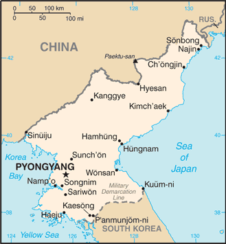 |
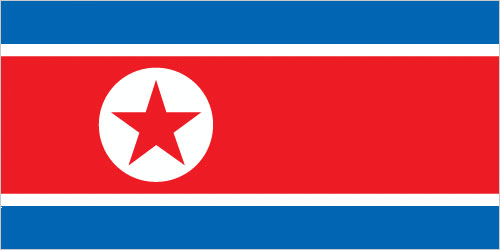
| The national flag of Korea North | Borderline map of Korea North |
| Flag description: three horizontal bands of blue (top), red (triple width), and blue; the red band is edged in white; on the hoist side of the red band is a white disk with a red five-pointed star; the broad red band symbolizes revolutionary traditions; the narrow white bands stand for purity, strength, and dignity; the blue bands signify sovereignty, peace, and friendship; the red star represents socialism. | Border length: total: 1,607 km. Border countries (total: 3): China 1,352 km, South Korea 237 km, Russia 18 km. |
Did you know about Korea North?
- The Kingdom of Korea was annexed by Japan in 1910. In 1948, the peninsula was partitioned into democratic South and communist North Korea.
- Only the political elite are allowed phones and private cars.
- The root of the ginseng plant, grown in both North and South Korea, is believed to nurture good health and energy.
Facts of Korea North (KP)
Name conventional long form: Democratic People’s Republic of Korea, conventional short form: North Korea, local long form: Choson-minjujuui-inmin-konghwaguk, local short form: Chosonabbreviation: DPRK, etymology: derived from the Chinese name for Goryeo, which was the Korean dynasty that united the peninsula in the 10th century A.D.; the North Korean name “Choson” means “[land of the] morning calm”
Codes: ISO; KP, Internet; .kp
Capital city: Pyongyang
Language(s): Korean
National holiday(s): Founding of the Democratic People’s Republic of Korea (DPRK), 9 September (1948)
Motto: N/A
Currency: Korean People’s won (KPW)
GPS: 40 00 N, 127 00 E, Pyongyang; 39 01 N 125 45 E
Location: Eastern Asia, northern half of the Korean Peninsula bordering the Korea Bay and the Sea of Japan, between China and South Korea
Geography note: strategic location bordering China, South Korea, and Russia; mountainous interior is isolated and sparsely populated
Land boundaries: China 1,352 km, South Korea 237 km, Russia 18 km, total: 1,607 km
Maritime boundaries: Yellow Sea, Korea Bay, Sea of Japan
Coastline: 2,495 km
Area: total: 120,538 sq km; land: 120,408 sq km, water: 130 sq km (total 46 540,74 mi2), slightly larger than Virginia; slightly smaller than Mississippi.
Roadways: total: 25,554 km, paved: 724 km, unpaved: 24,830 km (2006)
Waterways: 2,250 km (most navigable only by small craft) (2011)
Local time (capital): UTC+8.5, 13.5 hours ahead of Washington DC during Standard Time
Note to the local time: On 15 August 2015 North Korea reverted to UTC+8.5 a time zone that had been observed during pre-colonial times
Population in Korea North: 25,368,620
Population in Pyongyang: 3 222 000 (including the metropolitan areas)
Urbanization: urban population: 60.9% of total population (2015)
Major urban areas population: PYONGYANG (capital) 2.863 million (2015)
Population growth rate: 0.53% (2016 estimate)
Birth rate: 14.6 births / 1,000 population (2016 estimate)
Death rate: 9.3 deaths / 1,000 population (2016 estimate)
Age structure: 0-14 years: 20.97% (male 2,678,638 / female 2,588,744) 15-24 years: 15.88% (male 2,009,360 / female 1,977,942) 25-54 years: 44.22% (male 5,567,682 / female 5,537,077) 55-64 years: 9.19% (male 1,090,739 / female 1,218,406) 65 years and over: 9.74% (male 840,003 / female 1,606,720) (2016 estimate)
Median age: total: 33.8 years; male: 32.3 years, female: 35.4 years (2016 estimate)
Ethnic groups: racially homogeneous; there is a small Chinese community and a few ethnic Japanese
Religions: traditionally Buddhist and Confucianist, some Christian and syncretic Chondogyo (Religion of the Heavenly Way). Note: autonomous religious activities now almost nonexistent; government-sponsored religious groups exist to provide illusion of religious freedom
Government type: Unitary one-party republic
Legal system: civil law system based on the Prussian model; system influenced by Japanese traditions and Communist legal theory
National anthem: Aegukka
Known national hazards: late spring droughts often followed by severe flooding; occasional typhoons during the early fallvolcanism: Changbaishan (elev. 2,744 m) (also known as Baitoushan, Baegdu or P’aektu-san), on the Chinese border, is considered historically active
Major infectious diseases: N/A
Land use: agricultural land: 21.8%; arable land 19.5%; permanent crops 1.9%; permanent pasture 0.4%; forest: 46%; other: 32.2% (2011 estimate)
Agricultural products: rice, corn, potatoes, soybeans, pulses, beef, pork, eggs
Industries: military products; machine building, electric power, chemicals; mining (coal, iron ore, limestone, magnesite, graphite, copper, zinc, lead, and precious metals), metallurgy; textiles, food processing; tourism
Export commodities: minerals, metallurgical products, manufactures (including armaments), textiles, agricultural and fishery products
Main export partners: China 75.8% (2015)
Import commodities: petroleum, coking coal, machinery and equipment, textiles, grain
Main import partners: China 76.4%, Republic of the Congo 5.5% (2015)
Navigate the countries in Asia faster and easier while driving, use the interactive Google maps for your driving directions. The continuously updated database contains over 220 countries and territories digitally mapped, hundreds of millions of businesses and places around the world positioned on the map.
Get fresh GPS navigation, traffic, and transit information – no matter what part of Korea North, Pyongyang, any other city and country in Asia, or the world you’re in.
Do you like this Korea North information page? Please don’t forget to share it with others! Thank you.